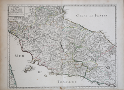
Italia centrale Adrian van Roomen Riferimento: S37845 Misure: 190 x 137 mm Anno: 1595 Luogo di Stampa: Francoforte Prezzo 380,00 € Anteprima Descrizione
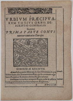
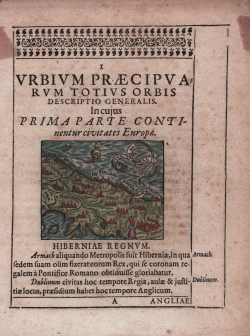
Urbium Praecipuarum Totius Orbis Descriptio Generalis. Incujus... Adrian van Roomen Riferimento: CO-234 Misure: 68 x 55 mm Anno: 1595 Luogo di Stampa: Francoforte Prezzo 450,00 € Anteprima Descrizione
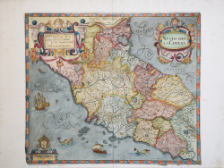
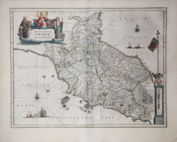
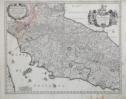
Stato della Chiesa Giovanni Antonio MAGINI Riferimento: CO-133 Misure: 430 x 375 mm Anno: 1607 ca. Luogo di Stampa: Bologna Prezzo 600,00 € Anteprima Descrizione
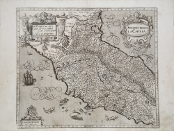
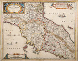
Stato della Chiesa Giovanni Antonio MAGINI Riferimento: S40982 Misure: 435 x 375 mm Anno: 1607 ca. Luogo di Stampa: Bologna Prezzo 500,00 € Anteprima Descrizione
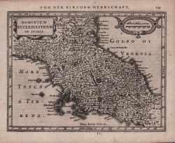
Dominium Ecclesiasticum in Italia Johannes JANSSONIUS Riferimento: S48170 Misure: 205 x 155 mm Anno: 1628 ca. Luogo di Stampa: Amsterdam Prezzo 150,00 € Anteprima Descrizione
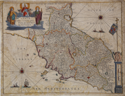
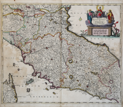
Stato della Chiesa con la Toscana Willem Janszoon BLAEU Riferimento: S43686 Misure: 500 x 390 mm Anno: 1634 ca. Luogo di Stampa: Amsterdam Prezzo 500,00 € Anteprima Descrizione
Stato della Chiesa. Dominium Ecclesiasticum in Italia Hendrick HONDIUS Riferimento: S29285 Misure: 530 x 420 mm Anno: 1636 ca. Luogo di Stampa: Amsterdam Prezzo 600,00 € Anteprima Descrizione
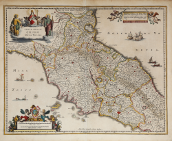
Stato della Chiesa con la Toscana Johannes JANSSONIUS Riferimento: MMS992 Misure: 525 x 420 mm Anno: 1640 ca. Luogo di Stampa: Amsterdam Prezzo 550,00 € Anteprima Descrizione
Estats de l'Eglise et de Toscane Nicolas SANSON Riferimento: CO-107 Misure: 565 x 430 mm Anno: 1648 Luogo di Stampa: Parigi Prezzo 400,00 € Anteprima Descrizione
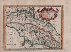
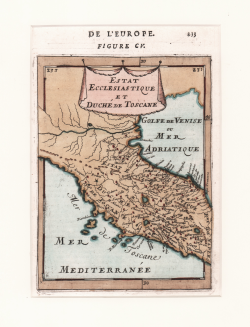
Les Tèrres de l'Eglise et la Toscane Philippe BRIET Riferimento: s29564 Misure: 200 x 150 mm Anno: 1649 Luogo di Stampa: Parigi Prezzo 225,00 € Anteprima Descrizione
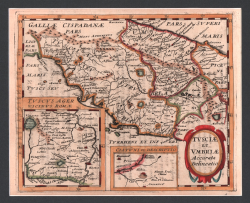
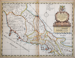
Tusciae et Umbriae Accurata Delineatio Philippe BRIET Riferimento: s29540 Misure: 200 x 160 mm Anno: 1649 Luogo di Stampa: Parigi Prezzo 250,00 € Anteprima Descrizione
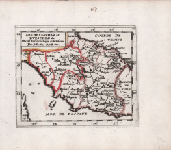
Archeveschez et Eveschez de l'Estat Ecclesiastique et de Toscane Pierre DUVAL Riferimento: CO-974 Misure: 125 x 105 mm Anno: 1662 Luogo di Stampa: Parigi Prezzo 280,00 € Anteprima Descrizione
Theatrum Civitatum et Admirandorum Italiae ad aevi veteris &... Johannes BLAEU Riferimento: 4208 Misure: - x - mm Anno: 1663 Prezzo 15.000,00 € Anteprima Descrizione
Descrittione dello Stato della Chiesa e della Toscana Michele Antonio BAUDRAND Riferimento: S43972 Misure: 560 x 435 mm Anno: 1669 ca. Luogo di Stampa: Roma Prezzo 700,00 € Anteprima Descrizione
Carta del Stato del Papa et del Gra. Duca di Toscana Pietro TODESCHI Riferimento: MS8201 Misure: 490 x 378 mm Anno: 1670 ca. Luogo di Stampa: Bologna Prezzo 1.200,00 € Anteprima Descrizione
Estat Ecclesiastique et Duché de Toscane Allain Manneson MALLET Riferimento: CO-563 Misure: 120 x 160 mm Anno: 1683 Luogo di Stampa: Parigi Prezzo 120,00 € Anteprima Descrizione
Status Ecclesiasticus et Magnus Ducatus Thoscanae Cornelis II DANKERTS Riferimento: CO-084 Misure: 605 x 505 mm Anno: 1696 ca. Luogo di Stampa: Amsterdam Prezzo 750,00 € Anteprima Descrizione
Italien Eigendlich also genandt Iohann STRIDBECK Riferimento: CO-206 Misure: 280 x 160 mm Anno: 1700 ca. Luogo di Stampa: Augsburg Prezzo 200,00 € Anteprima Descrizione
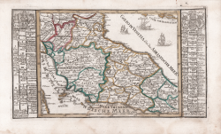
A New Map of Latium, Etruria, and as much of Ancient Italy, as lay... Edward WELLS Riferimento: CO-367 Misure: 490 x 365 mm Anno: 1700 ca. Luogo di Stampa: Oxford Prezzo 200,00 € Anteprima Descrizione
Etats De L'Eglise [...] Les Estats de Toscane Divisez [...] La... Jean Baptiste NOLIN Riferimento: CO-269 Misure: 640 x 480 mm Anno: 1702 ca. Luogo di Stampa: Parigi Prezzo 525,00 € Anteprima Descrizione
![Etats De L'Eglise [...] Les...](https://www.antiquarius.it/43549-home_default/etats-de-l-eglise.jpg)