| Riferimento: | S46071 |
| Autore | Abraham ORTELIUS |
| Anno: | 1584 ca. |
| Zona: | Cina |
| Luogo di Stampa: | Anversa |
| Misure: | 470 x 370 mm |
| Riferimento: | S46071 |
| Autore | Abraham ORTELIUS |
| Anno: | 1584 ca. |
| Zona: | Cina |
| Luogo di Stampa: | Anversa |
| Misure: | 470 x 370 mm |
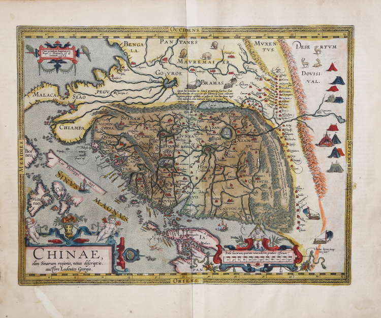
La carta della Cina di Ortelius è tratta direttamente dai resoconti del cartografo portoghese Luis Jorge de Barbuda (Ludovicus Georgius), che aveva realizzato una carta manoscritta della Cina, pervenuta a Ortelius tramite Arias Montanus. Pubblicata per la prima volta nel 1584, rappresenta la prima mappa stampata incentrata sulla Cina e la prima a illustrare la Grande Muraglia. Con i suoi tre ricchi cartigli ornamentali e le numerose illustrazioni di rifugi indigeni, mezzi di trasporto e animali, è tra le carte più decorate di Ortelius.
Al momento della sua apparizione, questa mappa era di gran lunga la più accurata rappresentazione della regione mai realizzata. Il Giappone è rappresentato su una curiosa proiezione curva che ricorda le carte portoghesi dell'epoca, con Honshu sezionato lungo la linea del lago Biwa. La Grande Muraglia è mostrata, ma solo in una sezione relativamente piccola, e la sua lunghezza è notevolmente sottostimata. Le "yurte" dei Tartari sono disseminate nelle pianure e nelle steppe dell'Asia centrale e orientale. I gesuiti portoghesi stabilirono una missione in Cina nel 1577. Sebbene il creatore portoghese della mappa, Barbuda, non fosse un gesuita, le sue fonti per la mappa erano quelle fornite da gesuiti portoghesi. I caratteri cinesi che si trovano nel testo sul retro della mappa sono stati la prima introduzione alla lingua cinese per molti colti europei dell'epoca.
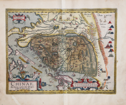
Il presente esemplare è il secondo dei tre stati della mappa; include il toponimo "Las Philippinas" sopra il Sinus Magnus. Il toponimo venne aggiunto nell'edizione francese del 1587 del Theatrum Orbis Terrarum.
“Until Martino Martini's map of 1655, this map by Luiz Jorge de Barbuda (fl.1575-1599) was the most influential Western portrayal of China. It was used also by Matteo Ricci (1552-1610) as a basis for his world map, Kunyu wanguo quantu (Complete map of the myriad countries of the world), that he prepared for the Wanli Emperor of China in 1602. Although the sixteenth century had seen Portuguese cartographers based in Lisbon or Goa regularly producing innovative maps of Asian regions, these typically provided detailed representation only of the coastal areas with which the Portuguese were most familiar; interior regions were portrayed as empty or filled with text captions and symbols of cities, animals, flags and so on, placed somewhat randomly. Following the establishment of the Portuguese presence in Macao, Lusitanian maps of the 1560s and 1570s showed China's coast with toponyms in Portuguese or in Portuguese transcriptions of Asian names. Examples are the East Asian atlas charts drawn by Portugal-based cartographers such as Diogo Homem (1561), Lázaro Luís (1563), or Sebastião Lopes et al. (c.1565), or even the Goa-based Fernão Vaz Dourado (1570). Likewise, Ortelius' own map of the East Indies of 1570 showed far less precision than this Barbuda's map, and its nomenclature was strikingly different.
In preparing his map, Barbuda likely has drawn on several kinds of sources: the unusually detailed 1561 map by Velho; Portuguese writings on China, especially those of João de Barros (1496-1570), Gaspar da Cruz (1520-1570) and Melchior Nunes Barreto (c.1520-1571); and maps that arrived in Europe via Macao and Manila. Some of these may have in turn drawn on Chinese sources. In his Third Decade of Asia (Lisbon, 1563), de Barros mentions using translations of Chinese books and maps, among them a cosmography with "maps showing the config ration of the land, and a commentary thereon in the form of an itinerary," that were prepared for him by a cultured Chinese servant. Both da Cruz and Barre visited Macao and Guangzhou during their time in Asia.
Bartolomeu Velho was a cartographer who, like Barbuda, worked in Lisbon and went to Spain in the 1570s. The China of his Asia chart, although not as detailed as Barbuda's, does indeed provide some information on the interior of China. The Great Wall is there, accompanied by a row of mountains; a large lake is depicted in the northwest, with a legend describing a flood that engulfed seven towns and 153 settlements in 1557; several drawings of Chinese cities appear, as well as the outline of a hydrographic system.
Barbuda's map, as it appears in Theatrum orbis terrarum, is horizontally oriented, with north to the right and south to the left, perhaps for reasons of graphic composition and to better fit the atlas format. The southern coast of China is rendered with significant detail: very jagged with bays and inlets of rivers and dotted with islands and toponyms with Portuguese-influenced names, including Macoa (Macao). The eastern coast is clearly less understood: it looks straighter with only half a dozen toponyms (Loureiro n.d.). The Chinese mainland, for the first time in Portuguese cartography, is bounded by successive mountain ranges. The Great Wall is shown to the north; it is not continuous but alternates with mountains” (cfr. Marco Caboara, Regnum Chinae The Printed Western Maps of China to 1735, pp. 169-173, n. 1).
Esemplare tratto dalla rara edizione italiana del Theatrum Orbis Terrarum stampata ad Anversa da Jean Baptiste Vrients nel 1608 e poi nel 1612.
Acquaforte con magnifica colorazione originale, ottimo stato di conservazione.
Bibliografia
Suarez (1999) “Early Mapping of South-East Asia”, p. 164-170, Figure 88; Van den Broecke, 164; Nebenzahl, K. Mapping the Silk Road and Beyond 4.6; Tooley, Maps and Mapmakers, p. 106, pl. 78 (p. 108); Walter, L. Japan: A Cartographic Vision 11F, p. 186. Van der Krogt III, 8410:31; Marco Caboara, Regnum Chinae The Printed Western Maps of China to 1735, pp. 169-173, n. 1.
Abraham ORTELIUS (1528 - 1598)
|
Abraham Ortel, più noto come Ortelius, nacque ad Anversa nel 1528, e qui avviò un’attività come commerciante di libri e “pittore di mappe”. Viaggiò molto, specialmente per recarsi alle gradi fiere librarie, stabilendo contatti professionali e amichevoli con altri cartografi europei dai quali derivò la sua collezione di mappe. Punto cruciale nella sua carriera fu il 1564, con la pubblicazione della Mappa del Mondo in otto fogli, di cui si conosce solo una copia. Nel 1570 pubblicò, in una stessa scala, la sua collezione di mappe sotto il titolo di Theatrum Orbis Terrarum, opera che di fatto costituì il primo esempio di atlante sistematico, sebbene il termine stesso verrà usato per la prima volta da Mercator venti anni più tardi. Il Theatrum, le cui mappe furono elegantemente incise per lo più da Frans Hogenberg, ottenne un successo immediato e conobbe ben 42 edizioni in varie lingue fino a quella definitiva del 1612, inclusa l’Appendix, pubblicata di tanto in tanto, con le ultime scoperte dell’epoca. Ortelius fu anche il primo a citare le sue fonti menzionando i nomi dei cartografi. Inoltre compilò una serie di mappe storiche col titolo Parergon Theatri. L’opera, contenente anche una riproduzione della Tabula Peutingeriana, edito per la prima volta nel 1579, fu pubblicata sia separatamente sia come parte integrante del Theatrum.
|