| Reference: | S46071 |
| Author | Abraham ORTELIUS |
| Year: | 1584 ca. |
| Zone: | China |
| Printed: | Antwerpen |
| Measures: | 470 x 370 mm |
| Reference: | S46071 |
| Author | Abraham ORTELIUS |
| Year: | 1584 ca. |
| Zone: | China |
| Printed: | Antwerpen |
| Measures: | 470 x 370 mm |
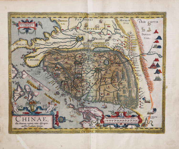
Ortelius' map of China is taken directly from the accounts of Portuguese cartographer Luis Jorge de Barbuda (Ludovicus Georgius), who had made a manuscript map of China, which came to Ortelius through Arias Montanus. First published in 1584, it represents the first printed map focusing on China and the first to illustrate the Great Wall. With its three rich ornamental cartouches and numerous illustrations of indigenous shelters, means of transportation and animals, it is among Ortelius' most ornate maps.
At the time of its appearance, this map was by far the most accurate depiction of the region ever made. Japan is depicted on a curious curved projection reminiscent of Portuguese maps of the time, with Honshu dissected along the line of Lake Biwa. The Great Wall is shown, but only in a relatively small section, and its length is greatly underestimated. Tartar "yurts" are scattered across the plains and steppes of Central and East Asia. Portuguese Jesuits established a mission in China in 1577. Although the map's Portuguese creator, Barbuda, was not a Jesuit, his sources for the map were those provided by Portuguese Jesuits. The Chinese characters found in the text on the back of the map were the first introduction to the Chinese language for many educated Europeans of the time.
The present example is the second of the three states on the map; it includes the toponym "Las Philippinas" above SINUS MAGNUS. The toponym was added in the 1587 French edition of Theatrum Orbis Terrarum.
“Until Martino Martini's map of 1655, this map by Luiz Jorge de Barbuda (fl.1575-1599) was the most influential Western portrayal of China. It was used also by Matteo Ricci (1552-1610) as a basis for his world map, Kunyu wanguo quantu (Complete map of the myriad countries of the world), that he prepared for the Wanli Emperor of China in 1602. Although the sixteenth century had seen Portuguese cartographers based in Lisbon or Goa regularly producing innovative maps of Asian regions, these typically provided detailed representation only of the coastal areas with which the Portuguese were most familiar; interior regions were portrayed as empty or filled with text captions and symbols of cities, animals, flags and so on, placed somewhat randomly. Following the establishment of the Portuguese presence in Macao, Lusitanian maps of the 1560s and 1570s showed China's coast with toponyms in Portuguese or in Portuguese transcriptions of Asian names. Examples are the East Asian atlas charts drawn by Portugal-based cartographers such as Diogo Homem (1561), Lázaro Luís (1563), or Sebastião Lopes et al. (c.1565), or even the Goa-based Fernão Vaz Dourado (1570). Likewise, Ortelius' own map of the East Indies of 1570 showed far less precision than this Barbuda's map, and its nomenclature was strikingly different.
In preparing his map, Barbuda likely has drawn on several kinds of sources: the unusually detailed 1561 map by Velho; Portuguese writings on China, especially those of João de Barros (1496-1570), Gaspar da Cruz (1520-1570) and Melchior Nunes Barreto (c.1520-1571); and maps that arrived in Europe via Macao and Manila. Some of these may have in turn drawn on Chinese sources. In his Third Decade of Asia (Lisbon, 1563), de Barros mentions using translations of Chinese books and maps, among them a cosmography with "maps showing the config ration of the land, and a commentary thereon in the form of an itinerary," that were prepared for him by a cultured Chinese servant. Both da Cruz and Barre visited Macao and Guangzhou during their time in Asia.
Bartolomeu Velho was a cartographer who, like Barbuda, worked in Lisbon and went to Spain in the 1570s. The China of his Asia chart, although not as detailed as Barbuda's, does indeed provide some information on the interior of China. The Great Wall is there, accompanied by a row of mountains; a large lake is depicted in the northwest, with a legend describing a flood that engulfed seven towns and 153 settlements in 1557; several drawings of Chinese cities appear, as well as the outline of a hydrographic system.
Barbuda's map, as it appears in Theatrum orbis terrarum, is horizontally oriented, with north to the right and south to the left, perhaps for reasons of graphic composition and to better fit the atlas format. The southern coast of China is rendered with significant detail: very jagged with bays and inlets of rivers and dotted with islands and toponyms with Portuguese-influenced names, including Macoa (Macao). The eastern coast is clearly less understood: it looks straighter with only half a dozen toponyms (Loureiro n.d.). The Chinese mainland, for the first time in Portuguese cartography, is bounded by successive mountain ranges. The Great Wall is shown to the north; it is not continuous but alternates with mountains” (cf. Marco Caboara, Regnum Chinae The Printed Western Maps of China to 1735, pp. 169-173, n. 1).
Example from the rare Italian edition of Theatrum Orbis Terrarum printed in Antwerp by Jean Baptiste Vrients in 1608 and again in 1612.
Etching with magnificent original coloring, excellent condition.
Bibliografia
Suarez (1999) “Early Mapping of South-East Asia”, p. 164-170, Figure 88; Van den Broecke, 164; Nebenzahl, K. Mapping the Silk Road and Beyond 4.6; Tooley, Maps and Mapmakers, p. 106, pl. 78 (p. 108); Walter, L. Japan: A Cartographic Vision 11F, p. 186. Van der Krogt III, 8410:31; Marco Caboara, Regnum Chinae The Printed Western Maps of China to 1735, pp. 169-173, n. 1.
Abraham ORTELIUS (1528 - 1598)
|
Abraham Ortel, better known as Ortelius, was born in Antwerp and after studying Greek, Latin and mathematics set up his business there with his sister, as a book dealer and 'painter of maps'. Travelling widely, especially to the great book fairs, his business prospered and he established contacts with many sultured men in many lands. On one such visit to England, possibly seeking temporary refuge from religious persecution, he met William Camden whom he is said to have encouraged in the production of the Britannia.
A turning-point in his career was reached in 1564 with the publication of a World Map in eight sheets of which only one copy is known: other individual maps followed and then - at the suggestion of a friend - he gathered together a collection of maps from contacts among European cartographers and had them engraved in uniform size and issued in 1570 as the Theatrum Orbis Terrarum (Atlas of the Whole World). Although Lafreri and others in Italy had published collections of 'modern' maps in book form in earlier years, the Theatrum was the first uniformly sized, systematic collection of maps and hence can be called the first atlas, although that term itself was not used until twenty years later by Mercator.
The Theatrum, with most of its maps elegantly engraved by Frans Hogenberg, was an instant success and appeared in numerous editions in different languages including addenda issued from time to time incorporating the latest contemporary knowledge and discoveries. The final edition appeared in 1612. Unlike many of his contemporaries Ortelius noted his sources of information and in the first edition acknowledgement was made to eighty-seven different cartographers.
Apart from the modern maps in his major atlas, Ortelius himself compiled a series of historical maps known as the Parergon Theatri which appeared from 1579 onwards, sometimes as a separate publication and sometimes incorporated in the Theatrum.
1570 Theatrum Orbis Terrarum 1570-1612 Between these years the Theatrum was re-issued in 42 editions with 5 supplements with text in Latin, Dutch, German, French, Spanish, Italian and English. The English edition was published in 1606 by John Norton, the maps being printed in Antwerp and the text added in London. Three years later Ortelius died in 1598, his heirs transferred publication rights to Jan Baptiste Vrients who produced the posthumous editions until he died in 1612
1577-85 Spiegel der Werelt (8vo) Maps from the Theatrum, reduced in size, engraved by Philip Galle: text by Pieter Heyns. 6 editions with Dutch, French and Latin text. 1588-i 603 Epitome theatri orbis terrarum (12mo/8v0) 11 further editions of the smaller maps with an increasing number of maps with text also in Italian and English (1603). i6oi-i 2 7 further editions with improved engravings by Arsenius Brothers: text by Michel Coignet in Latin, French, German, Italian and English (1603). 1598-1724 Theatro del Mondo (4t0/12mo/24mo) 8 editions with Italian text; plates engraved in Italy.
1579-1606 Parergon Theatri The number of maps included in the Parergon increased from 4 in 1579 to 43 in 1606 with text in Latin, French, Italian, German and English (1606) 1624 Re-issued in Antwerp as a separate publication by Balthasar Moretus. This edition included a reproduction of the Peutinger table.
|