| Riferimento: | S51189 |
| Autore | Thomas BOWEN |
| Anno: | 1789 |
| Zona: | Italia |
| Luogo di Stampa: | Londra |
| Misure: | 285 x 195 mm |
| Riferimento: | S51189 |
| Autore | Thomas BOWEN |
| Anno: | 1789 |
| Zona: | Italia |
| Luogo di Stampa: | Londra |
| Misure: | 285 x 195 mm |
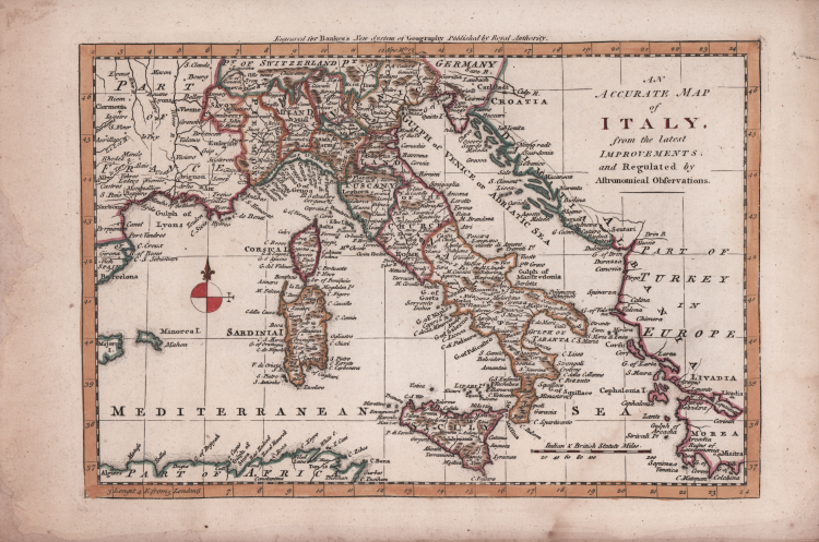
Carta geografica della penisola di Thomas Bowen, tratta da "A New Royal, Authentic and Complete System of Universal Geography", by Thomas Bankes, Edward Warren Blake, Alexander Cook & Thomas Bowen, printed for C. Cooke, No. 17, Pater-Noster Row (1789).
Acquaforte, finemente colorata a mano, in ottimo stato di conservazione.
|
Thomas Bowen (died 1790) was a Welsh engraver of charts. He was the son of Emanuel Bowen (1693/4–1767), map engraver to George II and Louis XV. He died in Clerkenwell workhouse early in 1790. He engraved the maps and charts of the West Indies, published by the direction of the government from the surveys of Captain James Speer; maps of the country twenty miles round London and of the road between London and St. David's, about 1750; a 'New Projection of the Eastern and Western Hemispheres of the Earth,' 1776; and an 'Accurate Map of the Russian Empire in Europe and Asia,' 1778; "A New & Accurate Map Of Europe From The Latest Improvements And Regulated By Astronomical Observations", engraved for Mountague's History of England. He contributed to George Taylor and Andrew Skinner's Survey and Maps of the Roads of North Britain in 1776.
|
|
Thomas Bowen (died 1790) was a Welsh engraver of charts. He was the son of Emanuel Bowen (1693/4–1767), map engraver to George II and Louis XV. He died in Clerkenwell workhouse early in 1790. He engraved the maps and charts of the West Indies, published by the direction of the government from the surveys of Captain James Speer; maps of the country twenty miles round London and of the road between London and St. David's, about 1750; a 'New Projection of the Eastern and Western Hemispheres of the Earth,' 1776; and an 'Accurate Map of the Russian Empire in Europe and Asia,' 1778; "A New & Accurate Map Of Europe From The Latest Improvements And Regulated By Astronomical Observations", engraved for Mountague's History of England. He contributed to George Taylor and Andrew Skinner's Survey and Maps of the Roads of North Britain in 1776.
|