[Carta nautica del Mediterraneo] Benedetto BORDONE Code: VR32IT Measures: 380 x 290 mm Year: 1528 ca. Printed: Venice Price €1,800.00 Quick view View Details
[...] Descrittione Particolare di tutti i luoghi, cosi maritimi,... Paolo FORLANI Code: S49230 Measures: 435 x 330 mm Year: 1571 Printed: Venice Price €24,000.00 Quick view View Details
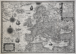
La vera descrittione della navigatione di tutta l’Europpa, et parte... Antonio LAFRERI Code: VR33IT Measures: 743 x 485 mm Year: 1572 Printed: Rome Call Us Quick view View Details
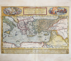
Peregrinationis Divi Pauli Typus Corographicus Abraham ORTELIUS Code: S46081 Measures: 500 x 350 mm Year: 1579 ca. Printed: Antwerpen Price €1,250.00 Quick view View Details
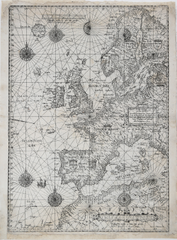
Universe Europe maritime eiusque navigationis descriptio Lucas Janszoon WAGHENAER Code: S49655 Measures: 395 x 555 mm Year: 1583 ca. Printed: Leyden Price €15,000.00 Quick view View Details
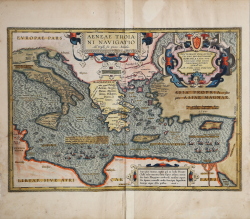
Aeneae Troiani Navigatio Ad Virgilij fex priores Aeneidos Abraham ORTELIUS Code: S46083 Measures: 500 x 348 mm Year: 1594 ca. Printed: Antwerpen Price €1,500.00 Quick view View Details
Europam ab Asia & Africa segregant Mare mediterraneum, Euxinus... Petrus PLANCIUS Code: VR03OL Measures: 545 x 395 mm Year: 1594 Printed: Amsterdam Price Not Available Quick view View Details
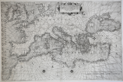
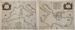
Chartam Mediterraneam antea magna obrutam falsitate.. Bartolomeo Crescenzio Code: VR34IT Measures: 595 x 745 mm Year: 1596 Printed: Rome Price €30,000.00 Quick view View Details
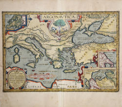
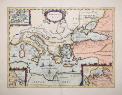
ARGONAUTICA Abraham ORTELIUS Code: S46080 Measures: 500 x 345 mm Year: 1598 ca. Printed: Antwerpen Price €1,500.00 Quick view View Details
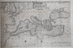
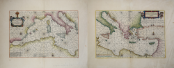
Navigatione dell’Europa con Parte dell’Africa et dell’Asia che con... Philippe THOMASSIN Code: S39814 Measures: 743 x 485 mm Year: 1606 Printed: Rome Price Not Available Quick view View Details
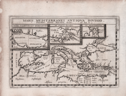
Maris Mediterranei Antiqua Divisio Philippe BRIET Code: CO-229 Measures: 200 x 130 mm Year: 1653 Printed: Paris Price €250.00 Quick view View Details
Argonautica Johannes JANSSONIUS Code: S40849 Measures: 510 x 385 mm Year: 1653 Printed: Amsterdam Price €500.00 Quick view View Details
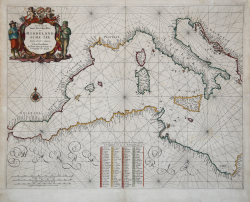
Ooster Deel der Middelantse Zee Nieulyex Beschreven by Iacob Colom Jacob Aertsz COLOM Code: S49657 Measures: 630 x 535 mm Year: 1656 ca. Printed: Amsterdam Price €3,500.00 Quick view View Details
Europa Uyt gegeven door Lowys Vlasbloem 't Amsterdam Louis Vlasbloem Code: VR09OL Measures: 254 x 178 mm Year: 1656 ca. Printed: Amsterdam Price €2,000.00 Quick view View Details
Una Carta Generale del mare Mediterranio. Carta prima Generale... Robert DUDLEY Code: VR39EN Measures: - x - mm Year: 1661 ca. Printed: Florence Price €10,500.00 Quick view View Details
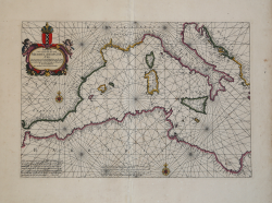
Pascaerte van 't westelyckste deel vande Middelandsche Zee Johannes VAN LOON Code: s21630 Measures: 455 x 305 mm Year: 1661 ca. Printed: Amsterdam Price €2,000.00 Quick view View Details
Pascaerte Van ‘t Westelyckste deel vande Middelandesche Zee &... Johannes VAN LOON Code: S49656 Measures: 455 x 315 mm Year: 1661 ca. Printed: Amsterdam Price €3,800.00 Quick view View Details
Paskaerte van’t Weftelyckste der Middelandsche Zee Pieter GOOS Code: s11215 Measures: 520 x 400 mm Year: 1662 ca. Printed: Amsterdam Price €1,500.00 Quick view View Details
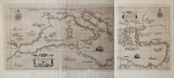
Paskaert van 't Westelycke deel Der Middelandsche Zee & Paskaert... Hendrick DONCKER Code: VR24OL Measures: - x - mm Year: 1664 Printed: Amsterdam Price €3,000.00 Quick view View Details
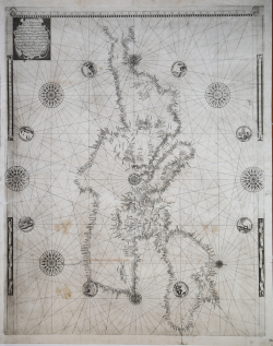
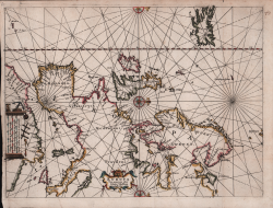
Prima parte dello specchio del mare nel quale si descrivono tutti... Francesco Maria LEVANTO Code: VR35IT Measures: - x - mm Year: 1664 Printed: Genua Price €24,000.00 Quick view View Details
![[...] Descrittione...](https://www.antiquarius.it/49083-home_default/al-molto-magco-et-mio-sigre-descrittione-particolare-di-tutti-i-luoghi-cosi-maritimi-come-fra-terra-ch-so-da-venetia-.jpg)