
| Reference: | VR39EN |
| Author | Robert DUDLEY |
| Year: | 1661 ca. |
| Zone: | Mediterranean Sea |
| Printed: | Florence |
| Measures: | - x - mm |
| Reference: | VR39EN |
| Author | Robert DUDLEY |
| Year: | 1661 ca. |
| Zone: | Mediterranean Sea |
| Printed: | Florence |
| Measures: | - x - mm |
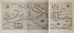
Etching and engraving, printed on two sheets (435x745 and 435 x365 mm), with margins, very good conditions.
Map of the Mediterranean Sea taken from the beutiful: Arcano Del Mare Di D’Ruberto Dudleo Duca Di Nortumbria e Conti Di Warvich Diuiso in libri sei. Nel primo, de' quali si tratta della longitudine praticabile in diuersi modi, d'inuenzione dell'Autore. Nel secondo, delle carte sue generali, e de' portolani rettificati in longitudine, e latitudine. Nel terzo, della disciplina sua marittima, e militare. Nel Quarto, Dell'Archittetura sua Nautica di Vascelli da guerra. Nel Quinto, Della Navigazione scientifica, e perfetta cioe Spirale ò di gran Circoli.". El volumen 2 contiene el libro sexto: "Nel sesto, Delle carte sue Geografiche, e Particolari in Fiorenze, MDCLXI.: In Firenze, Nella Stamperia di Francesco Onofri. 1646.
A rare and important charts of the Mediterranea Sea.
Dudley was the illegitimate son of Robert Dudley, Earl of Leicester, and brother-in-law of the celebrated circumnavigator Thomas Cavendish. Dudley joined the Royal Navy and led a privateering expedition to South America in 1594-1595. In 1596, he commanded the ship Nonpareil in the Earl of Essex's successful attack on Cadiz, and was knighted for his services.
Dudley sought to have his legitimacy established at court, but his attempts failed, and he fled abroad, eventually settling in Florence. Dudley was summoned to return to England but refused and was stripped of his titles and estates.
In Florence, Dudley put his naval experience to good use; he worked as a ship-builder, consulted on construction projects for harbours and their fortifications, while also writing his magnus opus, a handbook of navigation, ‘Dell’Arcano del Mare’.
An early manuscript version of the text survives in the Museo di Storia Naturale, in Florence, in three volumes, two dated 1610. A second, more complete version, dated [ca.1636-1646?] is in the Royal Library, Munich, containing a series of manuscript charts.
The printed version, ‘Dell’Arcano del Mare’ was published in Florence in 1646-1648 and re-issued as ‘Arcano Del Mare’ in Florence in 1661. The ‘Arcano’ (or ‘Secrets of the Sea’) was printed in six volumes, an encyclopaedia of matters marine from ship-building through to navigation and astronomy, containing large number of illustrations, technical diagrams, pictures of instruments and so on, but more importantly, a series of 146 charts covering all parts of the world.
The ‘Dell’Arcano’ is the first printed sea atlas of the world, and the charts form the first series constructed on the Mercator projection, a projection particularly suited to navigation. However, the ‘Dell’Arcano’ was too large for use on board ship, and too elaborate. The charts were engraved by Antonio Francesco Lucini, and are performed in an elaborate style, the lettering with long flourishes, elaborate compass roses and so on, an expensive production, in the preparation of which Lucini later noted that he had taken 12 years and used 5,000 pounds of copper.
The charts are puzzling. Some are clearly drawn from Dudley's own experiences, such as those of northern South America; some from other English sources, presumably communicated to him by brother officers at some point in his career; and some from charts that he owned, but the whole contains remarkable charts of all parts of the world, and not all the sources can be identified.
After his death, Dudley's library passed to Ferdinand II, Grand Duke of Tuscany, and much of it resides in the Bibliotheque Nazionale, Florence, including an interesting and important group of English manuscript charts, drawn by John Daniel, while the scientific instruments are to be found in the Museo Galileo, in the same city.
Dudley’s ‘Dell’Arcano’ is one of the most important of all sea atlases and yet it had no heirs and, seemingly, no influence, so it stands alone, a unique and as yet little understood masterpiece
Bibliografia: V. Arrighi, Robert Dudley, in “Dizionario Biografico degli Italiani”, Volume 41 (1992); Mare Nostrum, a historic voyage across the Mediterranean Sea, Lussemburgo, 2003, p. 30; W. Martigli, L’Arcano del mare di Robert Dudley, in Livorno. Progetto e storia di una città tra il 1500 e il 1600, Pisa 1980, pp. 191-197; National Maritime Museum, Catalogue of the Library - Vol. Three, Atlas & Cartography, Londra, 1971, pp. 386-387, n. 323 (16, 17); R. Shirley, Maps in the Atlases of the British Library, Londra, 2004, pp. 1164-1169, M.DUD-1a–1e (16, 17); G. Temple-Leader, Vita di Robert Dudley duca di Nortumbria, Firenze 1896.
|
S. Bifolco, "Mare Nostrum, Cartografia nautica a stampa del Mar Mediterraneo" (2020), pp. 196-197, tav. 85.
|
|
Illegittimate child of the Earl of Leicester, he was a skilful scientist, adventurer, mathematician and sailor. After travelling for some years along the Caribbean Islands, he was exiled in Italy, where he then settled in 1605, becoming Geographer of Ferdinando II, Garnduca of Tuscany. At his court, Didley realized the famous Dell’Arcano del Mare, a sea chart in six volumes, published for the first time in Florence in 1646/47 by Francesco Onofri, and then reprinted by Giuseppe Cocchini in 1661. The charts are known for the excelente execution and the quality of the enfraving, realized by the Folrentine artist Antonio Lucini.
1646/47 Dell’Arcano del Mare
|
|
S. Bifolco, "Mare Nostrum, Cartografia nautica a stampa del Mar Mediterraneo" (2020), pp. 196-197, tav. 85.
|
|
Illegittimate child of the Earl of Leicester, he was a skilful scientist, adventurer, mathematician and sailor. After travelling for some years along the Caribbean Islands, he was exiled in Italy, where he then settled in 1605, becoming Geographer of Ferdinando II, Garnduca of Tuscany. At his court, Didley realized the famous Dell’Arcano del Mare, a sea chart in six volumes, published for the first time in Florence in 1646/47 by Francesco Onofri, and then reprinted by Giuseppe Cocchini in 1661. The charts are known for the excelente execution and the quality of the enfraving, realized by the Folrentine artist Antonio Lucini.
1646/47 Dell’Arcano del Mare
|