| Reference: | VR24OL |
| Author | Hendrick DONCKER |
| Year: | 1664 |
| Zone: | Mediterranean Sea |
| Printed: | Amsterdam |
| Measures: | - x - mm |
| Reference: | VR24OL |
| Author | Hendrick DONCKER |
| Year: | 1664 |
| Zone: | Mediterranean Sea |
| Printed: | Amsterdam |
| Measures: | - x - mm |
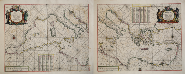
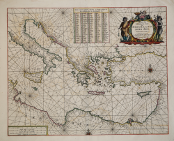
Paskaert van 't Westelycke deel Der Middelandsche Zee. Nieulycx gedruckt en uytgegeven T’ Amsterdam, By Hendrick Doncker Boekverkoper en Graadboogh maker inde Nieuw brugsteegh In ‘t Stuurmans gereedschap. A°. 1664 & Paskaert van 't Oostelycke deel Der Middelandsche Zee. Nieulycx gedruckt en uytgegeven T’ Amsterdam, By Hendrick Doncker Boekverkoper en Graadboogh maker inde Nieuw brugsteegh In ‘t Stuurmans gereedschap. A°. 1664
From: De Zee-Atlas Ofte Water-Waereld, Vertoonende all de Zee-kusten Van het bekende Deel des Aerd-Bodems, Met een generale beschryvinge van dien. Seer dienstigh voor alle Schippers en Stuurlieden; mitsgaders Koop-lieden om op ‘t Kantoor gebruykt te werden. Nieuwelijks aldus uytgegeven. t’ Amsterdam, By Hendrick Doncker, Boekveerkooper, en Graat-boog-maker, in dee Nieuwe-brug-steeg, in ‘t Stuur-mans Gereetschap. Anno. 1665.
Etching and engraving, 405x510 e 410x510 mm, signed in the upper cartouche.
Magnificient proofs, printed on contemporary laid paper, old hand-colors, in very good condition.
Although they bear the date 1664, the two charts are published only in the 1665 edition of the Zee-Atlas of Water-Waerelt, which includes four new charts and eight of the previous ones updated.
These two charts replace the first general chart of the Mediterraenan, divided into two sections, published by Doncker in 1660; they were used for all the numerous editions of the Zee-Atlas of Water-Waerelt, remaining unchanged - with the date An °. 1664 - until 1705, when Hendrick Doncker jr. inserts them, deleting the date, in the “De Nieuwe Groote Vermeerdere Zee-Atlas ofte Water-Werelt Vertoonende at the de Zee-Kunsten des Aerdtrycks, Seer dienstigh voor Schippers, Stuur-lieden en Liefhebbers der groote Zee-vaert”.
Extremely rare charts.
Bibliografia: C. Koeman, Atlantes Neerlandici: Bibliography of Terrestrial, Maritime and Celestial Atlases and Pilot Books Published in the Netherlands up to 1880 Vol. IV, Amsterdam 1970, pp. 152-189, Don 8A (30, 31); National Maritime Museum, Catalogue of the Library - Vol. Three, Atlas & Cartography, Londra, 1971, p. 77, n. 86 (nn. 51-52); cfr. R. Shirley, Maps in the Atlases of the British Library, Londra, 2004, pp. 1161-1163.
|
S. Bifolco, "Mare Nostrum, Cartografia nautica a stampa del Mar Mediterraneo" (2020), pp. 126-127, tav. 49.
|
|
For about fifty years Hendrick Doncker ran a flourishing business in Amsterdam as a bookseller and publisher of sea atlases and textbooks on navigation.
In a period when so many maps and charts were simply copied from other publishers, Doncker's charts were his own work and were noted for their accuracy and constant improvement.
Apart from this work, he cooperated for many years with Pieter Goos and Anthonie Jacobsz in producing a pilot guide De Zeespiegel. Eventually his stock was sold to Johannes van Keulen.
|
|
S. Bifolco, "Mare Nostrum, Cartografia nautica a stampa del Mar Mediterraneo" (2020), pp. 126-127, tav. 49.
|
|
For about fifty years Hendrick Doncker ran a flourishing business in Amsterdam as a bookseller and publisher of sea atlases and textbooks on navigation.
In a period when so many maps and charts were simply copied from other publishers, Doncker's charts were his own work and were noted for their accuracy and constant improvement.
Apart from this work, he cooperated for many years with Pieter Goos and Anthonie Jacobsz in producing a pilot guide De Zeespiegel. Eventually his stock was sold to Johannes van Keulen.
|