| Reference: | VR32IT |
| Author | Benedetto BORDONE |
| Year: | 1528 ca. |
| Zone: | Mediterranean Sea |
| Printed: | Venice |
| Measures: | 380 x 290 mm |
| Reference: | VR32IT |
| Author | Benedetto BORDONE |
| Year: | 1528 ca. |
| Zone: | Mediterranean Sea |
| Printed: | Venice |
| Measures: | 380 x 290 mm |
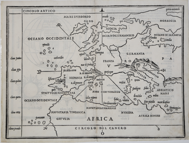
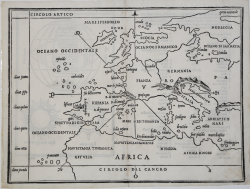
Woodcut, 290 x380, excellent condition.
From: “Libro di Benedetto Bordone nel qual si ragiona de tutte le isole del mondo con li lor nomi con li lor nomi antichi & moderni, historie, fauole, & modi del loro viuere, & in qual parte del mare stanno, & in qual parallelo & clima giacciono. Con il Breve di papa Leone. Et gratia & priviliegio della Illustrissima Signoria com’in quelli appare. M.D.XXVIII. Impresse in Vinegia per Nicolò d’Aristotele, detto Zoppino, nel mese di Giugno, del M.D.XXVIII.”
This is the first printed map of the area of the the Eastern Mediterranean, included in the famous Libro by Benedetto Bordone. Map without geographical grid, the orientation is provided by a schematic rose of eight winds.
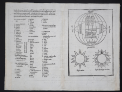
The author Bordone, born in Padua, worked in Venice as a geographer, cartographer, illuminator and wood-engraver. It is believed that he was the creator of the first globe printed in Italy. First published by Nicolò d'Aristotile detto Zoppino in 1528 under the title Libro di Benedetto Bordone nel qual si ragiona de tutte l'isole del mondo, the work, the second edition overall, marks the first appearance of the new title “Isolario”. The publisher re-used the same wood-blocks for the maps. An Aldine edition with the same title but different woodblocks followed in 1547. This work offers an illustrated guide to islands and peninsulas of the western ocean, the Mediterranean, the Indian Ocean and the Far East. As a cartographic form, Bordone's Isolario derives from two manuscript prototypes, Buondelmonti's Liber insularum Archipelagi of 1420 and Da Li Sonetti's Isolario of about 1485, whose maps were also drawn with eight windrays to establish orientation. Ptolemy's Geographia and nautical charts of the period are another source. This work is notable for its wide scope, spreading beyond the European/Western bounds of the well-known into the newly-discovered areas in the Americas. In addition to text which includes the first mention in book form of Pizarro's triumph, the maps of the area are also particularly important. These include a plan of the city of Mexico ("Temistitan"), showing it before its conquest by Cortes. The "Terra de Lavoratore" map on the verso of leaf VI contains what is considered the first printed map of continental North America. The verso of leaf XII contains a map of Hispaniola, and the following leaf bears a map of Jamaica on the recto and of Cuba on the verso. Other Caribbean islands depicted by maps include Guadeloupe, Dominica, and Martinique. Also of importance are the four double-page/folding maps: the World (one of the earliest oval projection world maps); Europe and north Africa; the eastern Mediterranean; and Venice and the surrounding lagoon. This work also includes one of the earliest European representations of Japan. The remaining majority of the maps illustrate islands in the Eastern Mediterranean.
Bibliografia: R. Almagià, Padova e l'Ateneo Padovano nella storia della scienza geografica, in Rivista geografica italiana XIX, 1912, pp. 471 s., 502-505; R. Almagià, Intorno alle carte e figurazioni annesse all'Isolario di B. B., in Maso Finiguerra, II, 1937, pp. 170-186 M. Billanovich, Dizionario Biografico degli Italiani - Volume 12, 1971; S. Crinò, Lo schizzo originario ined. del mappamondo di Benedetto Bordone, in “Comptes rendus du Congrès international de géographie”, Amsterdam 1938, II, p. 124; R. Fulin, Documenti per servire alla storia della tipogr. venez., in Arch. veneto, XXIII, 1882, pp. 113, 154 s., 168, 206; Mare Nostrum, a historic voyage across the Mediterranean Sea, Lussemburgo, 2003, p. 10; National Maritime Museum, Catalogue of the Library - Vol. Three, Atlas & Cartography, Londra, 1971, p. 19, n. 34 (11).
|
S. Bifolco, "Mare Nostrum, Cartografia nautica a stampa del Mar Mediterraneo" (2020), pp. 26-27, tav. 1.
|
|
Born in Padua, Bordone trained as an 'illuminator' and wood-engraver, working in Venice where, in 1508, he was given permission by the Senate to print maps of Italy and the world. No copies of these maps seem to have survived and he is known, therefore, only for his Isolano, printed in Venice in 1528.
Although issued as an 'Island Book' it gave prominence to discoveries in the New World and contained three full-size woodcut maps: the World, on an oval projection probably devised by the Florentine engraver, Francesco Rosselli, a map of Europe as a whole, and one of Greece and the North-Eastern Mediterranean. The remainder, about 80 woodcuts, are small maps or 'charts' set in the text of the book.
Isolano (small folio) 1534,1547, c. 1565 Re-issued
|
|
S. Bifolco, "Mare Nostrum, Cartografia nautica a stampa del Mar Mediterraneo" (2020), pp. 26-27, tav. 1.
|
|
Born in Padua, Bordone trained as an 'illuminator' and wood-engraver, working in Venice where, in 1508, he was given permission by the Senate to print maps of Italy and the world. No copies of these maps seem to have survived and he is known, therefore, only for his Isolano, printed in Venice in 1528.
Although issued as an 'Island Book' it gave prominence to discoveries in the New World and contained three full-size woodcut maps: the World, on an oval projection probably devised by the Florentine engraver, Francesco Rosselli, a map of Europe as a whole, and one of Greece and the North-Eastern Mediterranean. The remainder, about 80 woodcuts, are small maps or 'charts' set in the text of the book.
Isolano (small folio) 1534,1547, c. 1565 Re-issued
|