| Reference: | VR03OL |
| Author | Petrus PLANCIUS |
| Year: | 1594 |
| Zone: | Europe |
| Printed: | Amsterdam |
| Measures: | 545 x 395 mm |
| Reference: | VR03OL |
| Author | Petrus PLANCIUS |
| Year: | 1594 |
| Zone: | Europe |
| Printed: | Amsterdam |
| Measures: | 545 x 395 mm |
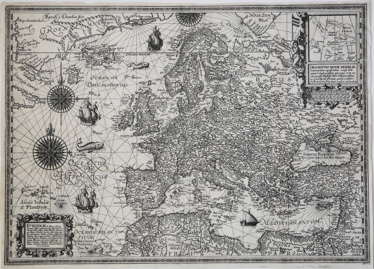
Europam ab Asia & Africa segregant Mare mediterraneum, Euxinus Pontus (nunc Mare Majus) Palus Meotides, Fluminaque Tanais et Duina. Continet celeberrimas regiones, Germaniam, Italiam, Galliam, Hispaniam, Daniam, Norvegiam, Suediam, Moscoviam, velpotius Russianm, Poloniam, cum Lituania, Hungariam, Illiricum er Graeciam: Insulasque insignes, Angliam et Scotiam, Hyberniam, Sardiniam, Corsicam, Siciliam, Candiam, Euboeam et Lemnum.
Etching and engraving, mm 395x545, signed upper left Baptista à Doetecum fecit. Example in its third state, with the David de Meyne’ publisher address added in the cartouche.
Magnificent example, printed on contemporary laid paper, thin margins, in excellent condition.
Inset map of the Novaja Zemlja island in upper right, lettered: Descriptio Novae Zemblae, ad quam penitius cognoscendam, mense Iulio proximè elapso presentis anni 1594. Certae naves expensis Illustriss. DD. Ordinum instructae è portu Texeiliae solventis, mari se commisere.
Chart of the Europe, drawing by designed by the cartographer and theologian Petrus Plancius, engraved by Baptista van Doetecum and published by Cornelis Claesz. The chart is embellished with numerous representations of ships and filled with directional lines that radiate from wind roses, typical decorations of the handwritten nautical charts, that undoubtedly are the cartographic sources for the work.
An important and curious cartographic aspect ot this map is the representation of the Nowaja Zemlja, or "New Earth" island to the north of Russia: its morphology on the map was already overcome at the time of its publication, and is originated from the Plancius’ world map published in 1592, where the island is separated from the great hypothetical polar mass.
In the upper right inset there’s a new and detailed map of the island, as a sort of correction. The Nowaja Zemlja is represented as a double-island, at west are depicted the new descovered lands , named “Sr. Hugo Willoughbes land', 'Macsinof Ilands', although they don’t existe.
The map was prepared at a time when the Dutch were searching for routes to the East Indies, including via the north-east passage. An inset shows a notional outline for Nova Zemla, with a comment that is "last July of the present year 1594, certain ships" were sent by the Dutch to explore the region, and by inference had not returned. As the expedition returned in September 1594, this establishes an unusual accurate date for the compilation of this map, so it’s possible that Plancius, receiving the news of the discoveries, immediately updated the map.
The first state of the plate bears both inscriptions printed with typefaces, on a piece of paper, then applied to the map. The second edition shows the inscriptions engraved in the plate, while in the third state the address of the editor David de Meyne is added in the cartouche above: Amsterdam Amsterdam by Davit de meijen inde werreltCart. Both the second and third states of the map are sometimes found in the first edition of the Cosmographia generalis by Paulus Merula, printed in Leiden in 1605. Merula's Cosmographiae generalis is completely focused on the description and history of the Europe, in particular on the geography of the Mediterranean and the ancient world.
According Henk Nails, the plate is related to the period in which the van Doetecum family was active in their own Haarlem workshop (around 1587-1600). The work, therefore, was probably made in Haarlem in 1592, before being published in Amsterdam by Cornelis Claesz first and then by David de Meyne
Bibliografia: H.A.M. van der Heijden, De Oudste gedrukte kaarten van Europa, Utrecht, 1992, p. 24; Mare Nostrum, a historic voyage across the Mediterranean Sea, Lussemburgo, 2003, p. 19; H. Nails, The Van Doetecum Family, in “The New Hollstein. Dutch & Flemish etchings, engravings and woodcuts 1450-1700”, Rotterdam, 1998, Vol. IV, p. 137, n. 923; G. Schilder, Monumenta Cartographica Neerlandica, Vol. III, Alphen aan den Rijn, 1990, p. 311, nota 216, fig. 3.104 e Vol. VII, 2003, pp. 80-83, n. 4.3, figg. 4.19; G. Schilder, Early Dutch Maritime Cartography. The North Holland School of Cartography (c. 1580-1620), Leida-Boston, 2017, pp. 193-196, ill. 5.21; F. C. Wieder, Monumenta Cartographica: reproductions of unique and rare maps, plans and views in the actual size of the originals, accompanied by cartographical monographs, The Haugue, 1925-33, vol. 2, p. 38, n. 19.
|
S. Bifolco, "Mare Nostrum, Cartografia nautica a stampa del Mar Mediterraneo" (2020), pp. 70-71, tav. 20.
|
|
Plancius was a theologian and minister of the Dutch Reformed Church who fled with many of his compatriots from religious persecution in Flanders to settle in Amsterdam in 1585. There he became interested in navigation and cartography and, being fortunate enough to have access to nautical charts recently brought from Portugal, he was soon recognized as an expert on the shipping routes to India. He was interested, too, in the idea of a North East passage until the failure of Willem Barentsz's third voyage in 1597 seemed to preclude the possibility of such a route. In 1602 he was appointed cartographer to the new Dutch East India Company.
Although Plancius produced no atlases his individual maps and charts, over 100 in all, exercised much influence on the work of other cartographers at the turn of the century. His very large wall map of the world dated 1592 was of particular significance.
|
|
S. Bifolco, "Mare Nostrum, Cartografia nautica a stampa del Mar Mediterraneo" (2020), pp. 70-71, tav. 20.
|
|
Plancius was a theologian and minister of the Dutch Reformed Church who fled with many of his compatriots from religious persecution in Flanders to settle in Amsterdam in 1585. There he became interested in navigation and cartography and, being fortunate enough to have access to nautical charts recently brought from Portugal, he was soon recognized as an expert on the shipping routes to India. He was interested, too, in the idea of a North East passage until the failure of Willem Barentsz's third voyage in 1597 seemed to preclude the possibility of such a route. In 1602 he was appointed cartographer to the new Dutch East India Company.
Although Plancius produced no atlases his individual maps and charts, over 100 in all, exercised much influence on the work of other cartographers at the turn of the century. His very large wall map of the world dated 1592 was of particular significance.
|