
| Reference: | VR35IT |
| Author | Francesco Maria LEVANTO |
| Year: | 1664 |
| Zone: | Mediterranean Sea |
| Printed: | Genua |
| Measures: | - x - mm |
| Reference: | VR35IT |
| Author | Francesco Maria LEVANTO |
| Year: | 1664 |
| Zone: | Mediterranean Sea |
| Printed: | Genua |
| Measures: | - x - mm |
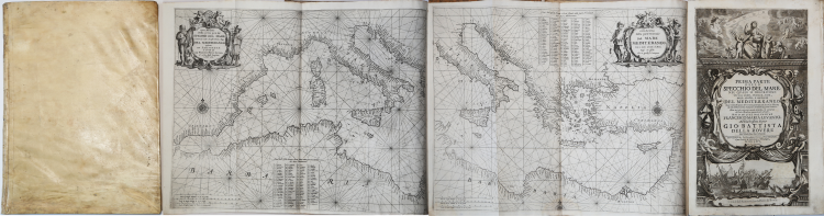
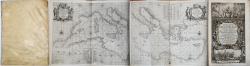
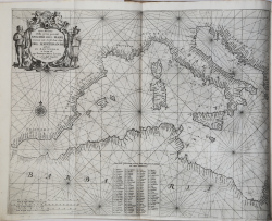
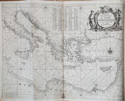
Prima parte dello specchio del mare nel quale si descrivono tutti li porti, spiaggie, baye, isole, scogli, e seccagni del Mediterraneo, con le dimostrationi de'terreni, cambiamenti di corse, e distanze, & il facilissimo modo d'adoprare il balestriglio, & astrolabio: non mai più così ampiamente descritto, & arrichito di carte maritime nuovamente costrutte [Genova, Gerolamo Marino e Benedetto Celle, 1664].
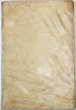
Folio (420x280 mm) with contemporary vellum binding; title within engraved borders, 152 pgs with diagram, coast profiles,engraved plans of harbours and 25 engraved maps (24 double page) related to Mediterranean coasts including a general map in two sheets.
A very nice copy of this rare atlas in its first edition. Coronelly used laterly these plates in 1696 for a second issue. The specchio is one of the earliest printed italian nautical atlases.
It is difficult to find much information on the Genoese captain Francesco Maria Levanto, who, at his own expense, printed all the best maps available at the time on the Mediterranean sea.
Levanto's atlas is a close copy of Pieter Goos's Zee-spiegel of 1662, the text on the charts being a direct translation into Italian from the Dutch. Certain of Levanto's plates were used by Vincenzo Maria Coronelli in editions of his Atlante Veneto from 1696 onwards, and also in a new edition of the present work, bearing the same title, but under Coronelli's imprint of 1698, the text and plates essentially unchanged.
The beautiful work describes the islands and the coasts of the Mediterranean through twelve "demonstrations"; the rich iconographic apparatus begins with two portolans of the Mediterranean, one dedicated to the western part, the other to the eastern part; every "demonstration" is accompanied by useful tables showing distances in Italian leagues.
Only this first part was ever published. A handsome book that drive us back to the XVII century when Venice still controlled the eastern Mediterranean sea routes.
Bibliografia: C. Astengo, L’Arte della vera navegatione, par Giovanni Francesco Monno, de Monaco (XVIIe siècle), in “Annales Monegasques. Revue d’Histoire de Monaco”, 24, 2000, pp. 7-30; C. Astengo, Alcune riflessioni sul Dizionario storico dei Cartografi Italiani, in “Bollettino della Società Geografica Italiana”, serie XII, vol. VII, 2003, p. 621; C. Astengo, The Renaissance Chart Tradition in the Mediterranean, in “The History of Cartography”, Vol. III, Chicago, 2007, pp. 193, 199, 206; M. Castelnovi, Nuova luce sulla produzione cartografica di Francesco Maria Levanto (circa 1664), in “Cartografi in Liguria (secoli XIV-XIX), Dizionario Storico dei Cartografi Italiani”, a cura di M. Quaini e L. Rossi, Genova, 2007, pp. 221-248; C. Koeman, Atlantes Neerlandici, Volume IV, p. 402, Lev I; National Maritime Museum, Catalogue of the Library - Vol. Three, Atlas & Cartography, Londra, 1971, p. 21, n. 36 (28) e p. 28, n. 42 (1-2); R. Shirley, Maps in the Atlases of the British Library, Londra, 2004, pp. 1222-1233, M.LEV-1a (1-2); V. Valerio, La tradizione degli Atlanti italiani, in L. Lago (a cura di), “Imago Italiae”, Trieste, 2002.
|
S. Bifolco, "Mare Nostrum, Cartografia nautica a stampa del Mar Mediterraneo" (2020), pp. , tav. .
|
Francesco Maria LEVANTO (Attivo intorno al 1664)
|
Following the footmark treaced by the colonial conquests and inside the great chart production the West India Company promoted, a lot very specific Atlases for sailors have been realized in Holland; some of them described the North Sea, or the Atlantic Sea or the whole world (H. Doncker, De Zee-Atlas, 1659; P. Goos, De Zee-Spiegel, 1650), few of them were about the Mediterranean Sea ( J.A. Colom, Colom de la Mer Mediterrannée, 1644). At the same time, in Italy, some publishers started to print Italian sea charts (Robert Dudley, Dell'arcano del mare, 1647). We have then to consider Levanto’s work inside this contest, for it was a very accurate and detailed one. To better understand the effort he put in this work, we must read the dedication “Al lettore” (To the reader), where it is said that the author has a great "prattica di passa 20 anni di navigatione" (20 years experience as a sailor) which he wants now to share with others through the moaning of the press. Apart from being the first Italian sea Atlas, entirely dedicated to the Mediterranean Sea, this is also a typographical masterpiece, due to all the xylographies and engraved big-size charts. In the XVI century, in fact, Italy was characterized by the realization of refined maps, apart from literary works or scientific branches of learning, which of course were enhanced by the clearness of the iconographic adornment, made up by the beautiful sea charts.
1664 First part of the Specchio del Mare
|
|
S. Bifolco, "Mare Nostrum, Cartografia nautica a stampa del Mar Mediterraneo" (2020), pp. , tav. .
|
Francesco Maria LEVANTO (Attivo intorno al 1664)
|
Following the footmark treaced by the colonial conquests and inside the great chart production the West India Company promoted, a lot very specific Atlases for sailors have been realized in Holland; some of them described the North Sea, or the Atlantic Sea or the whole world (H. Doncker, De Zee-Atlas, 1659; P. Goos, De Zee-Spiegel, 1650), few of them were about the Mediterranean Sea ( J.A. Colom, Colom de la Mer Mediterrannée, 1644). At the same time, in Italy, some publishers started to print Italian sea charts (Robert Dudley, Dell'arcano del mare, 1647). We have then to consider Levanto’s work inside this contest, for it was a very accurate and detailed one. To better understand the effort he put in this work, we must read the dedication “Al lettore” (To the reader), where it is said that the author has a great "prattica di passa 20 anni di navigatione" (20 years experience as a sailor) which he wants now to share with others through the moaning of the press. Apart from being the first Italian sea Atlas, entirely dedicated to the Mediterranean Sea, this is also a typographical masterpiece, due to all the xylographies and engraved big-size charts. In the XVI century, in fact, Italy was characterized by the realization of refined maps, apart from literary works or scientific branches of learning, which of course were enhanced by the clearness of the iconographic adornment, made up by the beautiful sea charts.
1664 First part of the Specchio del Mare
|