| Reference: | s21630 |
| Author | Johannes VAN LOON |
| Year: | 1661 ca. |
| Zone: | Mediterranean Sea |
| Printed: | Amsterdam |
| Measures: | 455 x 305 mm |
| Reference: | s21630 |
| Author | Johannes VAN LOON |
| Year: | 1661 ca. |
| Zone: | Mediterranean Sea |
| Printed: | Amsterdam |
| Measures: | 455 x 305 mm |
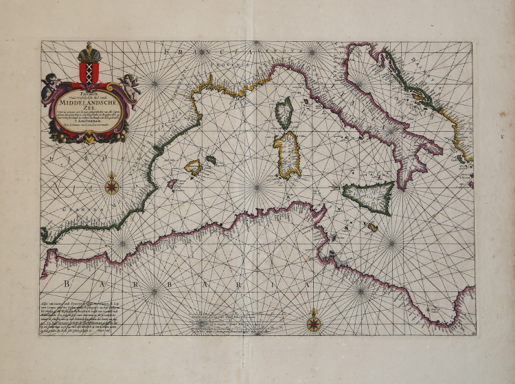
Pascaerte Van ‘t Westelyckste deel vande Middelandesche Zee; Waer in vertoont de ware gelegentheden van alle Capen, Havens, Rivieren, Bayen, Anckergronden en droogten, alles op haer rechte strecklingen en verheyt, nu Nieuwelyx int licht gebracht
Etching and engraving. Imprint in the cartouche: ’t Amsterdam, Door Iohannes van Loon Zeecaert-maker, op de S. Lucia burgwal in ‘t Sloterdycks steegie.
Rary early chart of The Mediterranean Sea, western part.
Magnificent example, printed on contemporary laid paper, with margins, old hand-colour, in excellent condition.
From: Klaer Lichtende Noort-Ster Ofte Zee Atlas; Waer in vertoont wordt De gelegentheydt van alle de Zee-kusten des geheelen Aerdtbodems, Nieuwelicks uyt-gegeven door Joannes van Loon. ‘t Amsterdam, By Ioannes van Loon, Plaet-snijder, buyten de S. Anthonis Poort, achter de Blancken Ham, in de 3. Vijsels, ofte by Gillis van Loon, achter de Hal, in de 3, Kemphaentjes, Anno 1661.
Johannes van Loon was a well-known mathematician who worked for a long time for various booksellers and map producers in Amsterdam. There are some doubts about the identities of Jan and Johannes van Loon because both names were circulated in the period 1649 - 1685. However, since both names appear in the notarial registers, in relation to a job with Johannes Janssonius van Waesbergen, it can be assumed that Jan and Johannes are the same person.
We do not know his date of birth but his death should have taken place in 1686. His name appears for the first time in the nautical guide published by Theunis Jacobsz in Amsterdam in 1649, the Practitioner in the Sciences of Astronomy, Geometry and the Mathematiques. Later, his name appears in a book written by Peter Ruelle entitled Voorlooper des Zee-quadrants ofte Ruitkaert, in the het licht gebracht door J. van Loon, printed by Hendrick Doncker in 1651.
Besides the profession of mathematician, he signed the maps for the famous marine atlas entitled Klaer-Lichtende Noort Ster published by him and his brother Gilles in 1661; before this date he had contributed to the composition of the nautical guides published by Johannes Janssonius such as Le Nouveau Flambeau de la Mer (1650), De Lichtende Columne (1651/52) and The Lighting Columne (1654). In 1666 the plates of the Klaer-Lichtende Noort Ster were sold to J. Janssonius van Waesbergen, who, in turn, reprinted the work, in collaboration with Van Loon, after having enriched it with twelve new maps, all signed by both cartographers.
Bibliografia: C. Koeman, Atlantes Neerlandici: Bibliography of Terrestrial, Maritime and Celestial Atlases and Pilot Books Published in the Netherlands up to 1880 Vol. IV, pp. 403-408, Loon 1 (13, 14); cfr. R. Shirley, Maps in the Atlases of the British Library, Londra, 2004, pp. 1223-1224.
|
S. Bifolco, "Mare Nostrum, Cartografia nautica a stampa del Mar Mediterraneo" (2020), pp. 120-121, tav. 46.
|
Johannes VAN LOON (Attivo tra il 1649-86)
|
Van Loon was a mathematician and engraver who contributed charts and maps to various pilot books and sea atlases by Jacobsz, Jan Jansson, Johannes J anssonius van Waesbergen and Robijn.In 1661he published a sea atlas, which was popular until the end of the century
|
|
S. Bifolco, "Mare Nostrum, Cartografia nautica a stampa del Mar Mediterraneo" (2020), pp. 120-121, tav. 46.
|
Johannes VAN LOON (Attivo tra il 1649-86)
|
Van Loon was a mathematician and engraver who contributed charts and maps to various pilot books and sea atlases by Jacobsz, Jan Jansson, Johannes J anssonius van Waesbergen and Robijn.In 1661he published a sea atlas, which was popular until the end of the century
|