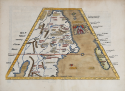
Ta. Superioris Indiae et Tartariae Maioris Laurent FRIES Code: S39558 Measures: 455 x 300 mm Year: 1522 ca. Printed: Strasbourg Price €2,800.00 Quick view View Details
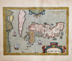
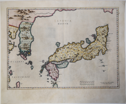
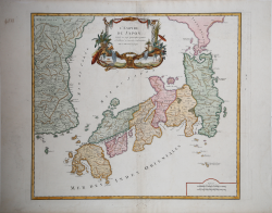
Iaponiae Insulae Descriptio Abraham ORTELIUS Code: S46072 Measures: 485 x 360 mm Year: 1595 ca. Printed: Antwerpen Price €2,800.00 Quick view View Details
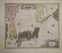
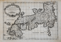
Nova et Accurata Iaponiae Terrae esonis ac Insularum adjacentium Johannes JANSSONIUS Code: MS5033 Measures: 545 x 450 mm Year: 1658 Printed: Amsterdam Price €1,600.00 Quick view View Details
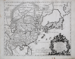
Il Regno della China detto presentemente Catay e Magin... Giacomo CANTELLI Code: S43965 Measures: 550 x 440 mm Year: 1682 Printed: Rome Price €1,300.00 Quick view View Details
Iaponia Regnum. Johannes BLAEU Code: S36147 Measures: 570 x 420 mm Year: 1688 ca. Printed: Amsterdam Price €1,200.00 Quick view View Details
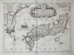
Isola del Giappone e Penisola di Corea Vincenzo CORONELLI Code: S45269 Measures: 620 x 470 mm Year: 1692 Printed: Venice Price €1,750.00 Quick view View Details
Iedo Capitale du Iapoi Pieter VANDER AA Code: ms6399 Measures: 780 x 290 mm Year: 1700 ca. Printed: Leyden Price €450.00 Quick view View Details
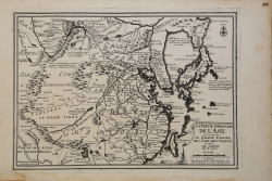
La Partie Orientale de L'Asie ou se trouvente Le Grand Empire des... Nicolas DE FER Code: MS4452 Measures: 335 x 245 mm Year: 1705 ca. Printed: Paris Price €300.00 Quick view View Details
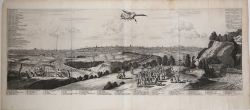
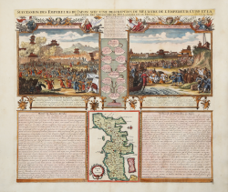
Succession des Empereurs du Japon avec une description du Meurtre... Henri Abraham CHATELAIN Code: MS1286 Measures: 443 x 382 mm Year: 1708 ca. Printed: Amsterdam Price €325.00 Quick view View Details
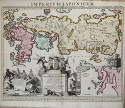
Imperium Japonicum Per Regiones Digestum Sex et Sexaginta Atque Ex... Adriaan Reland Code: S39544 Measures: 605 x 500 mm Year: 1715 ca. Printed: Amsterdam Price €1,900.00 Quick view View Details
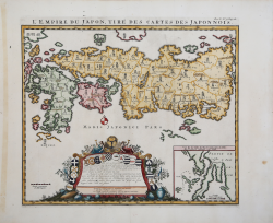
L'Empire du Japon, tiré des cartes des Japonnois Zacharias Chatelain Code: S42714 Measures: 445 x 385 mm Year: 1719 Price €1,100.00 Quick view View Details
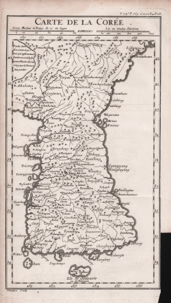
Carte de la Corée Jacques Nicolas BELLIN Code: S46650 Measures: 173 x 300 mm Year: 1736 Printed: Paris Price €325.00 Quick view View Details
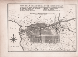
Plan de la Ville d Ozaca et de son Chateau Jacques Nicolas BELLIN Code: S46648 Measures: 305 x 206 mm Year: 1736 Printed: Paris Price €200.00 Quick view View Details
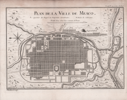
Plan de la Ville de Meaco Jacques Nicolas BELLIN Code: S46647 Measures: 295 x 215 mm Year: 1736 Printed: Paris Price €250.00 Quick view View Details
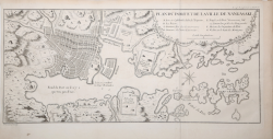
Plan du Port et de la Ville de Nangasaki Jacques Nicolas BELLIN Code: S46653 Measures: 455 x 215 mm Year: 1736 Printed: Paris Price €200.00 Quick view View Details
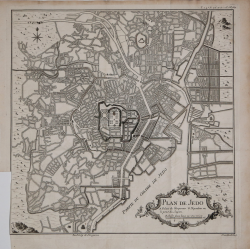
Plan de Jedo Jacques Nicolas BELLIN Code: S46651 Measures: 325 x 335 mm Year: 1736 Printed: Paris Price €300.00 Quick view View Details
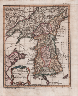
Carte de la Province de Quantong ou Lyau-tong et du Royaume de... Jacques Nicolas BELLIN Code: S43959 Measures: 230 x 280 mm Year: 1749 ca. Printed: Paris Price €375.00 Quick view View Details
L'Empire du Japon , divisé en sept principales et subdivisé en... Gilles Robert de VAUGONDY Code: S4887 Measures: 570 x 505 mm Year: 1750 ca. Printed: Paris Price €450.00 Quick view View Details
Karte von dem Reiche Japon Jacques Nicolas BELLIN Code: S11302 Measures: 315 x 225 mm Year: 1763 ca. Printed: Frankfurt Price €350.00 Quick view View Details
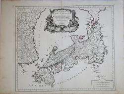
L'Empire Du Japon divisé en sept principales parties, savoir,... Francesco & Paolo SANTINI Code: S35712 Measures: 560 x 480 mm Year: 1778 Printed: Venice Price €450.00 Quick view View Details