| Reference: | MS4452 |
| Author | Nicolas DE FER |
| Year: | 1705 ca. |
| Zone: | China |
| Printed: | Paris |
| Measures: | 335 x 245 mm |
| Reference: | MS4452 |
| Author | Nicolas DE FER |
| Year: | 1705 ca. |
| Zone: | China |
| Printed: | Paris |
| Measures: | 335 x 245 mm |
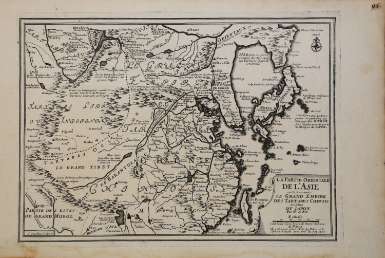
A map of China, Korea and Japan, by Nicolas De Fer, Royal French Geographer.
The island of Taiwan is labeled "I.Formosa ou Bel Isle".
This uncommon map is based on Jesuit missionary reports and is filled with historical and geographical notations. The map extends through Mongolia to the Ob River and Lake Baykal. The Great Wall and a road from Pekim (Beijing) to Narin (Narym) are among the details.
Map taken from "L'Atlas Curieux ou Le Monde Représenté dans des Cartes Générales et Particulières du Ciel et de la Térre" printed in Paris by Nicolas De Fer.
The "Atlas Curieux" is geographic encyclopedia of images and maps. issued in six annual parts from 1700-1705, the maps are based on the new observations of the Académie des Sciences, and drawn up with the assistance of Philipe de La Hire.
Copperplate, good condition.
Literature: McLaughlin 1334; Nordenskiöld 72 (re. 1725 ed.); Pastoureau Fer I A. a-d; Phillips 532; Tooley p. 42.
Nicolas DE FER (1646-1720 circa)
|
One of the most prolific and influential French geographers and cartographers of the late 17th and early 18th Century. Nicolas was the youngest son of Parisian print and mapseller, Antoine de Fer [d.1673]. He produced numerous atlases: Atlas Curieux [1700-5] and its subsequent suites; Atlas ou Receuil des Cartes [1709]; Atlas Royale [1699]; Les Beautés de la France [1708]; Atlases detailing wars and countries relating to the Spanish succession [1701]; Italy [1702] & Germany [1705] and Franco-Belgian frontiers [1708-10]; Les Forces de L'Europe [1690-95]; Introduction à la Géographie [1708]; the Petit Nouveau Atlas [1697]. Aswell as his Atlas output de Fer is also well known for his large Wall maps, some 26 in total, aswell as large-scale town plans of European cities, and a signifcant output of thematic printed card games. His sign and emblem was the Sphère Royale, originally that of Melchior Tavernier, to which he was greatly attached and which appears on a large number of his works. He died on 25th October 1720 and his estate was divided between his three daughters, all three of whose husbands were closely involved in the Parisian engraving and publishing business : Guillaume Danet, Remi Richer, Jaques-Francois Besnard or Bénard. A number of de Fer's maps and atlases continued to be published by his heirs for another twenty or thirty years.
|