| Reference: | S39558 |
| Author | Laurent FRIES |
| Year: | 1522 ca. |
| Zone: | China |
| Printed: | Strasbourg |
| Measures: | 455 x 300 mm |
| Reference: | S39558 |
| Author | Laurent FRIES |
| Year: | 1522 ca. |
| Zone: | China |
| Printed: | Strasbourg |
| Measures: | 455 x 300 mm |
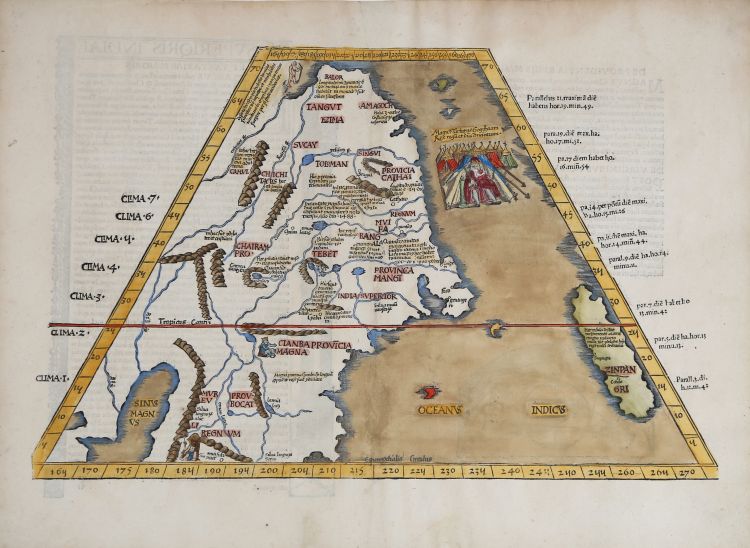
Second edition (1525) of the very important map of China by Laurent Fries, first issued in 1522 with the title on the top, within a banderole cartouche.
Fries map of eastern Asia is the first European map to focus on the region of Japan and China alone . This map derives from medieval sources, most notably Marco Polo, and extends from Tartary in the north, to "Prov. Bocat" (Cambodia) in the south. "Tebet" is shown prominently, as is "Zinpangri" (Japan), oriented north-south, along the right hand border. The map was produced for Fries's edition of Ptolemy's Geographia of 1522 and reissued in subsequent editions of 1525, 1535 & 1541.
The map is the first to illustrate Marco Polo's writings in cartographic form on a separate map dedicated exclusively to the Far East region. While there is no mention of the name China, many of the names used by Marco Polo are shown on the map. The Port of Quinzay [Hangzhou] is identified on the Eastern coast and Zinpangri [Japan] appears prominently across the sea from China. Curiously no mention is given to Polo's Zaiton. The great Tartar Khan sits in a tented encampment in the upper right of the image. Polo's division between Cathay in the Northern regions of China and Mangi or Manzi in the South is clearly illustrated.
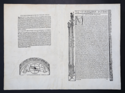
Presented on a trapezoidal projection in Ptolemaic format, the map extends well beyond the geography described by Ptolemy and draws from the reports of Marco Polo and contemporary European and Portuguese sources. Several regions in China are noted with numerous rivers and a huge lake labeled Sinis Magnus. In the Pacific, Fries includes a finely excited vignette of the Great Khan seated in his tent, before a great cluster of tents of his Tartar hordes. On the reverse are two pages of Latin historical text, the first flanked by woodcuts, while the second page ends with a diagram of astronomical instruments.
Unlike most maps in Frie's atlas, this map is not based upon an earlier map by Waldseemuller and is an entirely original production.
Woodcut with fine hand colour, expert repairs in the central fold, otherwise very good condition.
|
Walter, L. #3.
|
|
Lorenz (Laurent) Fries was born in Alsace in about 1490. He studied medicine, apparently spending time at the universities of Pavia, Piacenza, Montpellier and Vienna. After completing his medical studies, , Fries worked as a physician in several places, before settling in Strassburg, in about 1519. In Strassburg, Fries met the Strasbourg printer and publisher Johann Grüninger, an associate of the St. Die group of scholars formed by, among others, Walter Lud, Martin Ringmann and Martin Waldseemuller.From 1520 to 1525, Fries worked with Gruninger as a cartographic editor, exploiting the corpus of material that Waldseemuller had created. Fries' first venture into mapmaking was in 1520, when he executed a reduction of Martin Waldseemuller's wall-map of the World, published in 1507. Next Fries’ project was a new edition of the Geographia of Claudius Ptolemy, which was published by Johann Koberger in 1522. Fries evidently edited the maps, in most cases simply producing a reduction of the equivalent map from Waldseemuller's 1513 edition of the Geographie Opus Novissima, printed by Johann Schott. Fries also prepare three new maps for the Geographie: maps of South-East Asia and the East Indies, China and the World, but the geography of these derives from Waldseemuller's world map of 1507. The 1522 edition of Fries work , now very rare, was not commercially successful. In 1525, an improved edition was issued, from the notes of Johannes Regiomontanus. After Grüninger's death in 1531, the business was continued by his son Christoph, who seems to have sold the materials for the Ptolemy to two Lyon publishers, the brothers Melchior and Gaspar Trechsel, who published a joint edition in 1535, before Gaspar Trechsel published an edition in his own right in 1541.
|
|
Walter, L. #3.
|
|
Lorenz (Laurent) Fries was born in Alsace in about 1490. He studied medicine, apparently spending time at the universities of Pavia, Piacenza, Montpellier and Vienna. After completing his medical studies, , Fries worked as a physician in several places, before settling in Strassburg, in about 1519. In Strassburg, Fries met the Strasbourg printer and publisher Johann Grüninger, an associate of the St. Die group of scholars formed by, among others, Walter Lud, Martin Ringmann and Martin Waldseemuller.From 1520 to 1525, Fries worked with Gruninger as a cartographic editor, exploiting the corpus of material that Waldseemuller had created. Fries' first venture into mapmaking was in 1520, when he executed a reduction of Martin Waldseemuller's wall-map of the World, published in 1507. Next Fries’ project was a new edition of the Geographia of Claudius Ptolemy, which was published by Johann Koberger in 1522. Fries evidently edited the maps, in most cases simply producing a reduction of the equivalent map from Waldseemuller's 1513 edition of the Geographie Opus Novissima, printed by Johann Schott. Fries also prepare three new maps for the Geographie: maps of South-East Asia and the East Indies, China and the World, but the geography of these derives from Waldseemuller's world map of 1507. The 1522 edition of Fries work , now very rare, was not commercially successful. In 1525, an improved edition was issued, from the notes of Johannes Regiomontanus. After Grüninger's death in 1531, the business was continued by his son Christoph, who seems to have sold the materials for the Ptolemy to two Lyon publishers, the brothers Melchior and Gaspar Trechsel, who published a joint edition in 1535, before Gaspar Trechsel published an edition in his own right in 1541.
|