| Reference: | S11302 |
| Author | Jacques Nicolas BELLIN |
| Year: | 1763 ca. |
| Zone: | Japan |
| Printed: | Frankfurt |
| Measures: | 315 x 225 mm |
| Reference: | S11302 |
| Author | Jacques Nicolas BELLIN |
| Year: | 1763 ca. |
| Zone: | Japan |
| Printed: | Frankfurt |
| Measures: | 315 x 225 mm |
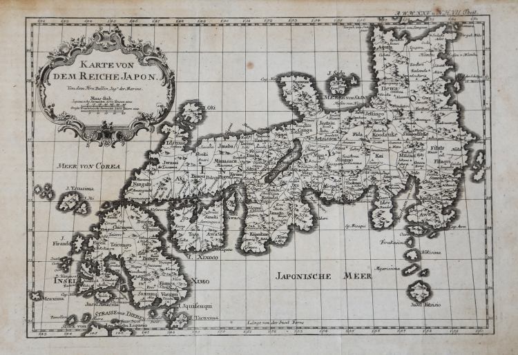
Geographic map of Japan in the rare German edition edited by Geubauer, printed approximately in 1763.
“The first state of the map is a direct copy of J.-N. Bellin's map included the previous year in the 10th volume of Prévost's Histoire Générale Des Voyages... The map appears in the 'Elfter Band' (vol. 11) of this Leipzig series.
In order to use the same plate for their French-language version, publishers Arkstee & Merkus had it reworked by translating the title cartouche back into French and adding French titles above the German ones to major features such as the seas of Japan and Korea; or by substituting French for German (Isle Awasi versus Insel Awası); or by adding French below the German (Partie des_Isles de Liqueio). In the second state, the subtitle has been altered to: Pour Servir a l'Histoire Universelle d'une Societé de Gens de Lettres from the original French Pour Servir a l'Histoire Générale des Voyages. The map appears in the 20th volume next to page 411.
The third state was included in an, as yet, unidentified publication." (Hubbard "Japoniae Insulae – The Mapping of Japan", p. 360).
Copper engraving, in excellent condition. Very rare.
Bibliografia:
Hubbard "Japoniae Insulae – The Mapping of Japan", pp. 360-362, n. 105.1; Walter, "Japan a cartographic vision", p. 224, n. 111.
Jacques Nicolas BELLIN (1703 - 1772)
|
Jacques-Nicolas Bellin (1703 - 1772) was one of the most important cartographers of the 18th century.
With a career spanning some 50 years, Bellin is best understood as transitional mapmaker spanning the gap
between 18th and early 19th century cartographic styles. His long career as Hydrographer and Ingénieur
Hydrographe at the French Dépôt des cartes et plans de la Marine resulted in hundreds of high quality
nautical charts of practically everywhere in the world. Bellin's work focuses on function and accuracy
tending in the process to be less decorative than the earlier 17th and 18th century cartographic work. In
addition to numerous maps and charts published during his lifetime, many of Bellin's maps were updated
(or not) and published posthumously. He was succeeded as Ingénieur Hydrographe by his student, also a prolific and influential cartographer, Rigobert Bonne.
|