| Reference: | S4887 |
| Author | Gilles Robert de VAUGONDY |
| Year: | 1750 ca. |
| Zone: | Japan |
| Printed: | Paris |
| Measures: | 570 x 505 mm |
| Reference: | S4887 |
| Author | Gilles Robert de VAUGONDY |
| Year: | 1750 ca. |
| Zone: | Japan |
| Printed: | Paris |
| Measures: | 570 x 505 mm |
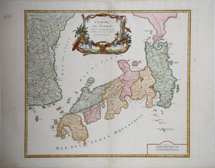
Map of the island taken from the "Atlas Universel..", published in Paris in 1750.
Large map of Japan and Korea with a distinctively French style title cartouche containing two small landscapes.
The map draws heavily on the previous work of Bellin, but includes a number of improvements to Terre d' Yedso (Hokkaido) similar to the manuscripts of Engelbert Kaempfer.
The fictitious island of Matsumae is removed and now Matsaki is shown as a part of Yedso. The provinces are clearly outlined and there are many place names. The eastern part of the Korean peninsula is also shown with a good amount of detail.
This great map was to influence the cartography of Japan well into the 19th century.
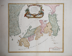
“The engraver, perhaps Santini himself, responsible for copying De Vaugondy's map, was faithful to the original place-names, keeping all words in French and producing a very close facsimile of the elaborate cartouche. When it came to copying the mountain chains in Japan and Korea he apparently ignored some, such as in the southwest corner of Kyūshū, or reduced their length, as in a number of places in Korea.
The first state was published in an atlas with a title-page dated 1776 although the map bears the date 1778. The atlas was published by the Venetian brothers Francesco, and Paolo Santini, who were editor and engraver, respectively. Paolo Santini (c.1729-1793) was born in Venice and, besides being an engraver and mapmaker, was a professor of design. Valerio (1993) writes that the Santini's were not among the subscribers of Robert de Vaugondy's Atlas Universel and that no documentation appears to exist of an agreement between the French and the Venetian publishers. He goes on to point out that the maps were copied so rigorously, giving full credit as to the source, thus probably saving them from the accusation of plagiarism. The Atlas Universel, writes Valerio, "does not appear to have been a success, and that accounts for the rarity of the first edition..."
Economic circumstances forced Santini to sell the plates in 1781 to Giuseppe Antonio Remondini (1747-1811), who continued publication of the atlas until 1804. Remondini published the atlas in two volumes but made no changes to the map other than adding his name in the cartouche below that of Santini, and placing a binder's direction in the upper right corner. Remondini "...was an audacious and bold publisher in Bassano and Venice" (Valerio 1997). The Remondini's expanded their business in a number of directions including printing, paper production and type foundry work and claimed to have made money from the re-publication of Santini's atlas, with the addition of 12 plates in the second edition of 1784. The atlas was reissued in 1804 by Joseph Remondini and sons." (Hubbard "Japoniae Insulae – The Mapping of Japan", p. 374).
Bibliografia:
Hubbard "Japoniae Insulae – The Mapping of Japan", pp. 374-375, n. 114; Walter "Japan a cartographic vision", p. 223, 100 (cat. N. 86).
Gilles Robert de VAUGONDY (1688 - 1766)
|
Didier Robert de Vaugondy (1723-1786) was appointed Geographer to Louis XV in 1760. At the same time, de Vaugondy served as Geographer to the Duke of Lorraine and Bar, father-in-law to Louis XV and former King of Poland.
His major contributions to French cartography are the Atlas Universel, 1750-57, The Nouvelle Atlas Portatif (1784) and a very popular map of North America published in 1761. He was son of Gilles Robert de Vaugondy who succeeded Pierre Sanson as the King's Geographer.
|