
| Reference: | S36147 |
| Author | Johannes BLAEU |
| Year: | 1688 ca. |
| Zone: | Japan |
| Printed: | Amsterdam |
| Measures: | 570 x 420 mm |
| Reference: | S36147 |
| Author | Johannes BLAEU |
| Year: | 1688 ca. |
| Zone: | Japan |
| Printed: | Amsterdam |
| Measures: | 570 x 420 mm |
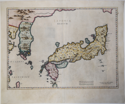
Nice example of Blaeu's map of Japan & Korea from Joan Blaeu's Atlas Sinensis.
While titled as a map of Japan, perhaps the single most noteworthy feature of this map is as the first map to show Korea correctly as a peninsula, as opposed to an island on earlier maps.
“"The publication of the Atlas of China seems to owe more to coincidence than to planning" writes Peter van der Krogt in his description of the Atlas Sinensis, where this map was first included. The Atlas Sinensis was first published in 1655 and added to the Theatrum Orbis Terrarum as the sixth volume. Most of the examples of this map have a blank verso, the exceptions being the second French printing of 1655 and the Spanish text version in 1658-1659. The Atlas Sinensis was later consolidated with the maps of Asia and was issued as the Asia volume in the Atlas Maior.
Martino Martini (1614-1661) went to China in 1642 as a Jesuit missionary and was ordered back to Rome in 1651, taking with him a number of maps of the provinces of China which he translated into Latin. On his voyage back to Europe he was captured by the Dutch and was sent to Amsterdam where he arrived in 1654. In addition to his contribution to the cartography of the Far East he wrote a history of the war of the Tartars against China.
To date, four states of this map have been identified. The first, without the privilege, may be an early proof and can only be tentatively dated c.1655; to date only loose examples of this state have surfaced. The second and most common state was included in Blaeu's production, which has been painstakingly and exhaustively researched by Peter van der Krogt. The third and fourth states are a result of Blaeu's plates being dispersed after the firm's fire of 1672. Sometime early in the eighteenth century the plate for this map (and a number of others) was acquired by Pieter Mortier and the third state of this map, with his imprint, could safely be dated c.1710, the year before his death. Mortier's widow continued the business for another decade and the plate once again changed hands and became part of the inventory of Covens and Mortier, an association of Johannes Covens, who had married Agatha Mortier in 1721, and Cornelis Mortier, Peter's son. The fourth state can tentatively be dated c. 1721; Van Egmond (2009) mentions that Blaeu's Atlas Sinensis was re-issued by Covens and Mortier "ca. 1721-ca. 1725" and that some of the maps with their imprint have survived, including that of Japan. Both the third and fourth state were included in composite atlases and probably issued separately as well. Over the past few years a number of composite atlases have been taken apart and it becomes more and more difficult to establish when either of these states was first issued. A curious feature of the fourth state is the added imprint Per F. de Wit, which, as Tony Campbell has pointed out to the present author, is anachronistic and may have been added by Mortier to give it respectability.
After the Blaeu firm suffered a disastrous fire in 1672, and the death of Joan Blaeu the following year, the complete stock of books, atlases and plates was sold by public auction. The copperplates were originally acquired by Abraham Wolfgang and were sold in 1694 after his death.." (Hubbard "Japoniae Insulae – The Mapping of Japan", p. 195).
Copperplate with fine original colour, washed and refreshed, otherwise good condition.
Bibliografia:
Hubbard "Japoniae Insulae – The Mapping of Japan", pp. 195-198, n. 27; Walters, 38; OAG, 28
Johannes BLAEU (Alkmaar 1596 circa - Amsterdam 1663)
|
Joan Blaeu was the eldest son of Willem Janszoon Blaeu (1571-1638), and was probably born in Alkmaar in the province of Noord-Holland in the final years of the 16th century. He was brought up in Amsterdam, and studied law at the University of Leiden before going into partnership with his father in the 1630s. He became chief cartographer to the Dutch East India Company from 1638, and from 1651 to 1672 he served on the Amsterdam City Council without a break, holding several public offices. He also invested in Dutch colonial interests in North America. Joan Blaeu main work was Theatrum Orbis Terrarum (or Atlas Maior as it had became known.) Atlas had expanded to between 9 and 12 volumes, depending on the language. With over 3,000 text pages and approximately 600 maps, it was the most expensive book money could buy in the later 17th century. In 1638 Willem Blaeu died and the business passed into the hands of his sons, Joan and Cornelis, who continued and expanded their father's ambitious plans. After the death of Cornelis, Joan directed the work alone and the whole series of 6 volumes was eventually completed about 1655. As soon as it was finished he began the preparation of the even larger work, the Atlas Major, which reached publication in 1662 in II volumes (later editions in 9-12 volumes) and contained nearly 6oo double-page maps and 3,000 pages of text. This was, and indeed remains, the most magnificent work of its kind ever produced; perhaps its geographical content was not as up-to-date or as accurate as its author could have wished, but any deficiencies in that direction were more than compensated for by the fine engraving and colouring, the elaborate cartouches and pictorial and heraldic detail and especially the splendid calligraphy. In 1672 a disastrous fire destroyed Blaeu's printing house in the Gravenstraat and a year afterwards Joan Blaeu died. The firm's surviving stocks of plates and maps were gradually dispersed, some of the plates being bought by F. de Wit and Schenk and Valck, before final closure in about 1695.
|