
| Reference: | S42714 |
| Author | Zacharias Chatelain |
| Year: | 1719 |
| Zone: | Japon |
| Measures: | 445 x 385 mm |
| Reference: | S42714 |
| Author | Zacharias Chatelain |
| Year: | 1719 |
| Zone: | Japon |
| Measures: | 445 x 385 mm |
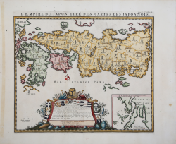
Fine example of Chatelain's edition of Adrien Reland's important map of Japan.
Reland's map of Japan represents a radical departure from prior European maps of Japan and is the first map printed in Japan to use Sino-Japanese characters. Instead of following prior European maps and geographical sources, Reland utilized Japanese maps, most notably a map from the library or Benjamin Dutry, a former director of the Dutch VOC (East India Company). In some respects, this represented a tremendous leap forward in the geographical depiction of Japan, such as in the treatment of Kyushu and in naming the 66 provinces.
The map first appeared in 1715, published in Utrecht by Wilehm Broedelet and immediately afterwards - the same year - in Amsterdam, in the version by Jean-Frédéric Bernard and followed by the one published in Rouen by Jean-Baptiste Machuel le jeune (1716).
Chatelain copied Reland's map in 1719 for his Atlas Historique, although there are a few translation errors from the original.
In his recent publication on the charts of Japan, Jason Hubbard attributes the map to Zacharias Chatelain: “This map is contained in the fifth volume of the massive seven-volume Atlas Historique a publication commonly attributed to the Chatelain brothers, Henri Abraham and Zacharie, together with Zacharie's son-in-law Francois L'Honore. Recent publications, however, assert that the author of the work was in fact Zacharie Chatelain alone. The map was copied from Reland, including the place-names in phonetic Dutch with at least two notable engraving errors where Suruga, Soeroega in the 1715 Reland, has now become Soepoega, and Kinocuni has been rendered Knocuni.
The text in the cartouche explains that the map has been copied from a similar one made by the Japanese and therefore needs no alteration, and continues that the inset was taken from a map drawn on site by a Dutchman.
Van Waning (2010) writes, in an article on Chatelain's Atlas Historique that it "... is possibly the first work in which the words 'atlas' and 'historical' are directly linked." He goes on to give credit for the compilation of this work to Zacharie Chatelain, citing Goffart (2003). It took 15 years to finish the first printing of the seven volumes (1705-1720) and the last known printing, for volume 1 only, took place in 1739. Different volumes were published in different years, probably as a result of individual volumes being sold out, making it difficult to establish exact "editions". Koeman (1967-85 II) compiled a detailed list, based on 8 sets of volumes, and their dates, in European and American libraries; he concludes that there were a total of three editions between 1705 and 1737 and the beginning of a fourth, with only the first volume printed in 1739. Van Waning makes a case for four editions, the final one consisting of volumes dated variously from 1732 to 1739. Insofar as the present, and following, map the present author is not aware of any changes in either the map itself or in the pagination” (cfr. Jason C. Hubbard, Iaponiae Insulae, The Mapping of Japan, p. 294).
Large inset of the area around Nagasaki and an ornate dedication cartouche, with about 20 coats of arms.
Henri Abraham Chatelain (1684 - 1743) was a Huguenot pastor of Parisian origins. He is best known as a Dutch cartographer and more specifically for his cartographic contribution in the seminal seven volume Atlas Historique, published in Amsterdam between 1705 and 1720. Innovative for its time, the Atlas Historique combined fine engraving and artwork with scholarly studies of geography, history, ethnology, heraldry, and cosmography. Some scholarship suggests that the Atlas Historique was not exclusively compiled by Henri Chatelain, as is commonly believed, but rather was a family enterprise involving Henri, his father Zacharie and his brother, also Zacharie.
Copperplate with fine later hand colour, perfect condition.
Bibliografia
Jason C. Hubbard, Iaponiae Insulae, The Mapping of Japan, pp. 293-294, n. 73; Goffart 2003: 132-133 and 174, note 1; Hubbard & Walter 1994: OAG 71; Koeman 1967-85 II: Cha 1-8; Shirley 2004: T.CHAT-5a; Van der Krogt 1985: 239 and 769; Van Waning 2010
Zacharias Chatelain (1690-1754)
|
Zacharias was the young brother of the well known Henri Abraham Chatelain (1684 - 1743), a Huguenot pastor of Parisian origins. He is best known as a Dutch cartographer and more specifically for his cartographic contribution in the seminal seven volume Atlas Historique, published in Amsterdam between 1705 and 1720. Innovative for its time, the Atlas Historique combined fine engraving and artwork with scholarly studies of geography, history, ethnology, heraldry, and cosmography. Some scholarship suggests that the Atlas Historique was not exclusively compiled by Henri Chatelain, as is commonly believed, but rather was a family enterprise involving Henri, his father Zacharie and his brother, also Zacharie.
|