
| Reference: | s50502 |
| Author | Jodocus HONDIUS |
| Year: | 1598 ca. |
| Zone: | The World |
| Printed: | Amsterdam |
| Measures: | 125 x 90 mm |
| Reference: | s50502 |
| Author | Jodocus HONDIUS |
| Year: | 1598 ca. |
| Zone: | The World |
| Printed: | Amsterdam |
| Measures: | 125 x 90 mm |
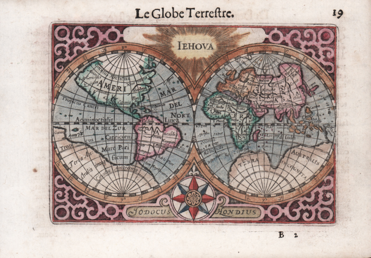
Attractive and rare little World map by Hondius printed in the Hague for Cornelis Claesz.
Double hemisphere map is finely engraved with a strapwork surround, the name Iehova at top, and a compass rose with Jodocus Hondius' imprint at bottom. Terra Australis Incognita fills the Southern Hemisphere and nearly connects to New Guinea in the region of Australia. Due to the small size of the map, there are only a few place names and only the major topographical features are delineated. Anian, Nova Francia, Norobega, Florida, California, and Hispania Nova are noted in North America.
First published in Barent Langenes' “Caert-thresoor” published in Amsterdam by Cornelis Claesz in 1598. Example from the French text edition of 1609 with the title “Thrésor de Chartes contenant les Tableux de tout les pays du monde, enrichi de belles descriptions, revue & augmenté” printed in Frankfurt by Matthias Becker on behalf of publisher Henry Laurent.
Barent Langenes was a Middelburg publisher about whom not much is known except that he produced the first edition of a well-known miniature atlas, the “Caert-Thresoor”. The atlas was published by Cornelis Claesz of Amsterdam, the leading publisher of the time.
The Caert-Thresoor, a small atlas of the world in oblong format, appeared in 1598; its publishers thus wrote a new page in the history of cartography. Preparations for this prototype of the new generation of Dutch pocket atlases began around 1595. At that time, Cornelis Claesz commissioned the maps from the skilled engravers Jodocus Hondius and Pieter van den Keere. An unnamed young writer and poet, Cornelis Taemsz of Hoorn, was called in to write the accompanying text. Claesz wanted his Caert-Thresoor to surpass the similar small atlases of the world produced up to that time in Antwerp by Abraham Ortelius In this way, he aimed to arouse interest in and knowledge of geography among the general public in the northern Netherlands.
The Caert-Thresoor enjoyed wide interest and from a commercial point of view. Under Claesz's editorship, editions appeared in Dutch (1598, 1599, and 1609), French (c. 1600 and 1602), and Latin (1600, 1602/03, and 1606). But even after his death, the work continued to undergo a series of editions at different publishing houses. Beginning with the 1599 Dutch edition, influenced by Paulus Merula's criticism, most of the maps were given a latitude scale. Claesz approached Aelbert Hendricksz of The Hague to print the French edition based on a translation by I. de la Haye, who was rector and clergyman in Kampen. For the Latin edition, however, production again took place in Amsterdam, but this time in collaboration with a publisher in Arnhem, Jan Jansz. For this edition, scholar Petrus Bertius (1565-1629) produced a completely new geographical description of the entire world. In addition, the maps served as illustrations, unlike earlier editions in which the text was intended to explain the maps. In 1609, the Caert-Thresoor appeared in a new Dutch version, prepared by author and poet Jacobus Viverius (1571/72-c.1636).
Etching, fine later hand colour, in very good condition.
Bibliografia
Shirley #182; Van der Krogt (Vol. III) #0001:341B.1; King, Miniature Antique Maps, pp. 80-82.
Jodocus HONDIUS (Amsterdam 1563 - 1612)
|
Jodocus Hondius (1563-1612) was a foremost map engraver of his day; he worked for many Dutch publishers, and was employed by the English map and print-sellers, Sudbury and Humble, to engrave the maps for John Speed’s The Theatre of The Empire of Great Britaine, published in 1612. In 1604, Hondius bought the copperplates of Mercator’s Atlas at the auction of Gerard Jr.’s effects. He added another forty maps, including new maps of the Continents and important regional maps of the Americas, before publishing a new edition of the Atlas, in 1606, in competition with Ortelius’ Theatrum. As many of the maps were more up-to-date, the Mercator-Hondius Atlas effectively superseded Ortelius’ Theatrum. On his death in 1612 his widow, Coletta van den Keere continued the business; from 1619 onwards their son Henry (II) (1597-1651) took over. From 1633 publication was carried on in co-operation with Jan Jansson Jr., Henry’s brother-in-law.
|
Jodocus HONDIUS (Amsterdam 1563 - 1612)
|
Jodocus Hondius (1563-1612) was a foremost map engraver of his day; he worked for many Dutch publishers, and was employed by the English map and print-sellers, Sudbury and Humble, to engrave the maps for John Speed’s The Theatre of The Empire of Great Britaine, published in 1612. In 1604, Hondius bought the copperplates of Mercator’s Atlas at the auction of Gerard Jr.’s effects. He added another forty maps, including new maps of the Continents and important regional maps of the Americas, before publishing a new edition of the Atlas, in 1606, in competition with Ortelius’ Theatrum. As many of the maps were more up-to-date, the Mercator-Hondius Atlas effectively superseded Ortelius’ Theatrum. On his death in 1612 his widow, Coletta van den Keere continued the business; from 1619 onwards their son Henry (II) (1597-1651) took over. From 1633 publication was carried on in co-operation with Jan Jansson Jr., Henry’s brother-in-law.
|