

| Reference: | S52500 |
| Author | Frederick de WIT |
| Year: | 1665 ca. |
| Zone: | The World |
| Printed: | Amsterdam |
| Measures: | 575 x 480 mm |
| Reference: | S52500 |
| Author | Frederick de WIT |
| Year: | 1665 ca. |
| Zone: | The World |
| Printed: | Amsterdam |
| Measures: | 575 x 480 mm |
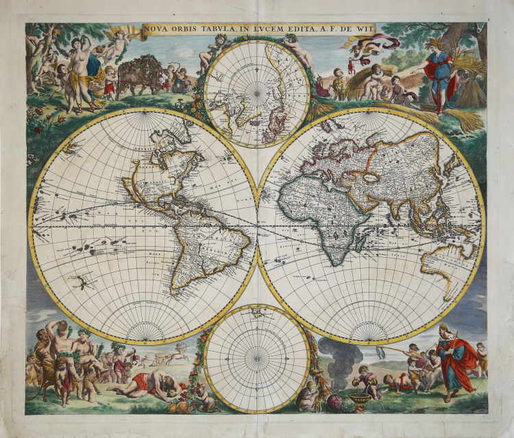
One of the most decorative 17th century Dutch globes.
A magnificent example of the first state Frederick De Wit's classic double-hemisphere world map.
Shirley praised it as "one of the finest of its time."
De Wit's map represents the state of the art of Dutch cartography, as expressed in Nicolas Visscher's 1658 world map, whose details are drawn primarily from Johannes Blaeu's Nova et Accuratissima Totius Terrarum Orbis Tabula. Both in geographical detail and in the composition of the primary and subordinate hemispheres, it is a faithful copy of Visscher's map.
This example is in the first of two plate states, without the cherubs on the cusps and the ornamental frame; the second plate state features numerous geographical updates, with new discoveries in the Pacific and the interior of the American continent. This first state includes California as an island according to Briggs' prototype and the Strait of Anian. New Guinea does not yet appear in the Pacific of the Western Hemisphere.
“De Wit's globe is one of the most attractive of the period. The brilliant scenes in the corners combine the images of the four seasons, the elements, and the signs of the zodiac in a balanced and naturalistic manner” (see Shirley, R.W. The Mapping of the World, p. 468).
De Wit (c. 1629–1706) was a cartographer and map dealer born in Gouda, who worked and died in Amsterdam. From 1660 onward, he is best known for his atlases and maps of Dutch cities. After his death, most of the plates passed to Pieter Mortier, whose firm became Covens & Mortier, one of the largest cartographic firms of the 18th century.
Etching, beautiful contemporary coloring with some retouching, minor restorations to the lower white border, otherwise in excellent condition.
Bibliografia
Shirley, R.W. The Mapping of the World, p. 468, n. 451.
Frederick de WIT (1630 - 1706)
|
De Wit was one of the most prominent and successful map engravers and publishers in Amsterdam in the period following the decline of the Blaeu and Jansson establishments, from which he acquired many copper plates when they were dispersed at auction. His output covered most aspects of map making: sea charts, world atlases, an atlas of the Netherlands, 'town books' covering plans of towns and cities in the Netherlands and Europe, and wall maps. His work, notable for the beauty of the engraving and colouring, was very popular and editions were issued many years after his death by Pieter Mortier and Covens and Mortier.
|
Frederick de WIT (1630 - 1706)
|
De Wit was one of the most prominent and successful map engravers and publishers in Amsterdam in the period following the decline of the Blaeu and Jansson establishments, from which he acquired many copper plates when they were dispersed at auction. His output covered most aspects of map making: sea charts, world atlases, an atlas of the Netherlands, 'town books' covering plans of towns and cities in the Netherlands and Europe, and wall maps. His work, notable for the beauty of the engraving and colouring, was very popular and editions were issued many years after his death by Pieter Mortier and Covens and Mortier.
|