| Reference: | MS2641 |
| Author | Gerard DE JODE |
| Year: | 1578 |
| Zone: | Portugal |
| Printed: | Antwerpen |
| Measures: | 520 x 300 mm |
| Reference: | MS2641 |
| Author | Gerard DE JODE |
| Year: | 1578 |
| Zone: | Portugal |
| Printed: | Antwerpen |
| Measures: | 520 x 300 mm |
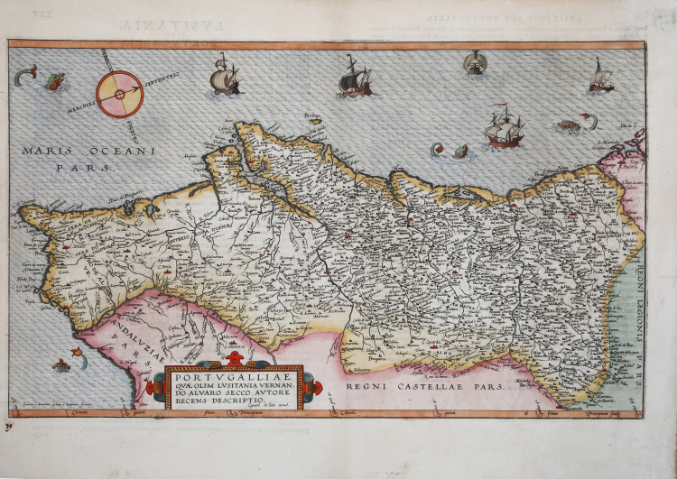
Rare map of Portugal based on Fernando Alvaro Seco's model, published in Rome by Francesco Tramezzino in 1561. Oriented with west at the top.
The map, prepared in 1565, is published in Gerard de Jode's Speculum Orbis Terrarum, printed in Antwerp only in 1578 and reprinted in 1593 by his son Cornelis de Jode.
“La prima carta a stampa del Portogallo è dovuta al matematico e cartografo Fernando Alvares Seco, di cui nulla è noto, esponente della nota famiglia di origini milanesi. Viene stampata a Roma dall’editore Michele Tramezzino ed incisa dal suo fedele collaboratore Sebastiano del Re. L’opera è dedicata al cardinal Guido Sforza (morto nel 1564) dal suo allora segretario e bibliotecario, l’umanista e filologo portoghese Achille Stazio (1524-1581). La data riportata nel cartiglio, 13 giugno 1561, potrebbe essere quella dell’originale manoscritto ed è quindi possibile che la carta sia stata stampata qualche anno dopo, ma comunque prima del 1564, anno della morte del cardinal Sforza. L’opera influenzò la cartografia della regione per i due secoli successivi; la prima replica fu realizzata ad Anversa dal De Jode (1565), seguita subito da quella di Abraham Ortelius (1570). La carta è descritta nel catalogo della tipografia Lafreri (n. 13, come “Portogallo”), che dunque acquistò la lastra dal Tramezzino.” (cfr. Bifolco-Ronca, Cartografia e topografia italiana del XVI secolo, (2018) p. 1128, tav. 471).
Gerard de Jode was a celebrated engraver and printer, a native of Nijmegen in 1509. After studying mathematics and cosmography, he learned the art of engraving, was for some time at the court of Charles V in Brussels, then moved to Antwerp, where as early as 1551 he began to print artistic engravings by Franz Huys, Martin de Vos, Corneille de Cort, etc. ; but soon specialized in engraving maps and printed in Antwerp the famous world map of Giacomo Gastaldi, in 1568 Italy by the same, then other maps by many authors, including Italians, in 1564 a large world map by Abraham Ortelius (Nova totius Terrarum Orbis iuxta neotericorum traditionem descriptio) and finally in 1578 a full-fledged atlas with the title Speculum Orbis Terrarum, in 65 plates, by different authors, already partly published in isolation. It is one of the earliest modern atlases (preceded only by Ortelius' Theatrum), which is extremely rare today. In the last years of his life he waited to prepare large maps of the individual continents, which were perhaps later published, on a par with a great world map, by his son Cornelius. The latter, born in Antwerp in 1568, continued his father's work with great sagacity; in 1589 he published a world map, in 1593 a new edition of the Speculum, enlarged, in 109 maps, and in 1596 an Introductio geographica in tabulas Europae, Asiae, Africae et Americae; the plates, alluded to here, are probably those prepared by his father and of which his son took care of the printing; they have not, however, come down to us. Cornelius then traveled extensively in the Nordic countries and also in Spain. Returning to his homeland, he died in Mons on October 17, 1600.
Etching and engraving, by brothers Johannes or Lucas van Deutecum, finely hand-colored, in excellent condition.
Rare first edition with Roman numbering XXV on verso.
Bibliografia
cfr. Bifolco-Ronca, Cartografia e topografia italiana del XVI secolo, (2018) p. 1128, tav. 471; Cortesao & Teixera (1987): p. 79-80, tav. 197; Karrow (1993): n. 67/1.3; The New Hollestein (Doetecum), vol. III, n. 575; Imagens de Portugal e Ilhas Atlanticas, p. 80 n. 24.
|
Gerard de Jode, born in Nijmegen, was a cartographer, engraver, printer and publisher in Antwerp, issuing maps from 1555 more or less in the same period as Ortelius. He was never able to offer very serious competition to his more businesslike rival although, ironically, he published Ortelius's famous 8-sheet World Map in 1564.
His major atlas, now extremely rare, could not be published until 1578, eight years after the Theatrum, Ortelius having obtained a monopoly for that period. The enlarged re-issue by his son in 1593 is more frequently found. On the death of Cornelis, the copper plates passed to J. B. Vrients (who bought the Ortelius plates about the same time) and apparently no further issue of the atlas was published: however, at least one further issue of the Polar Map, c.1618, is known.
Son of Gerard de Jode, who was a cartographer, engraver, printer and publisher in Antwerp, issuing maps from 1555 more or less in the same period as Ortelius.
Gerard de Jode's major atlas, now extremely rare, could not be published until 1578, eight years after the Theatrum, Ortelius having obtained a monopoly for that period. The enlarged re-issue by his Cornelis in 1593 is more frequently found.
On the death of Cornelis, the copper plates passed to J. B. Vrients (who bought the Ortelius plates about the same time) and apparently no further issue of the atlas was published: however, at least one further issue of the Polar Map, c.1618, is known.
|
|
Gerard de Jode, born in Nijmegen, was a cartographer, engraver, printer and publisher in Antwerp, issuing maps from 1555 more or less in the same period as Ortelius. He was never able to offer very serious competition to his more businesslike rival although, ironically, he published Ortelius's famous 8-sheet World Map in 1564.
His major atlas, now extremely rare, could not be published until 1578, eight years after the Theatrum, Ortelius having obtained a monopoly for that period. The enlarged re-issue by his son in 1593 is more frequently found. On the death of Cornelis, the copper plates passed to J. B. Vrients (who bought the Ortelius plates about the same time) and apparently no further issue of the atlas was published: however, at least one further issue of the Polar Map, c.1618, is known.
Son of Gerard de Jode, who was a cartographer, engraver, printer and publisher in Antwerp, issuing maps from 1555 more or less in the same period as Ortelius.
Gerard de Jode's major atlas, now extremely rare, could not be published until 1578, eight years after the Theatrum, Ortelius having obtained a monopoly for that period. The enlarged re-issue by his Cornelis in 1593 is more frequently found.
On the death of Cornelis, the copper plates passed to J. B. Vrients (who bought the Ortelius plates about the same time) and apparently no further issue of the atlas was published: however, at least one further issue of the Polar Map, c.1618, is known.
|