| Reference: | S39520 |
| Author | Gerard & Leonard VALCK |
| Year: | 1710 ca. |
| Zone: | Southern Italy |
| Printed: | Amsterdam |
| Measures: | 500 x 580 mm |
| Reference: | S39520 |
| Author | Gerard & Leonard VALCK |
| Year: | 1710 ca. |
| Zone: | Southern Italy |
| Printed: | Amsterdam |
| Measures: | 500 x 580 mm |
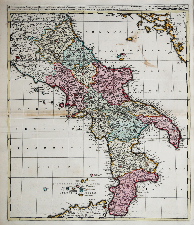
Regnum Neapolis, subdivisum in suas peculiares Provincias Aprutium nempe Ulter: et Citerius, Comit: Molisinum; prine Ulter et Citeriorem; Regiones Lavorinas, Dauniam, Agrum Barianum, Messapiam, Basilicatam, Calabriam Citer: et Ulterior.”.
Carta geografica pubblicata ad Amsterdam da Gerard e Leonard Valck, padre e figlio, ai primissimi del Settecento all'interno del loro Atlantis sylloge compendiosa or Nova totius Geographia. Di questo atlante, poco noto, si conoscono varie edizioni pubblicate tra il 1702 e il 1710 con un numero di carte variabile da 20 a 100. Si trova anche in: Nieuwe Atlas... di Johannes Covens e Cornelis Mortier del 1740 са.
Anche cartograficamente questa carta di Gerard e Leonard Valck rispecchia la visione del territorio dei primi del XVIII secolo, con la riduzione della strozzatura tra Tirreno ed Adriatico lungo la linea Gaeta-Tremiti; la crescita esagerata delle dimensioni della Calabria a cui fa da contraltare la riduzione del Salento che appare decisamente snello. Nel golfo di Taranto è segnato con evidenza il Monte Sardo, immaginaria isola inventata dal Magini nella sua carta d'Italia del 1608 che, benché cancellata nel suo Regno di Napoli stampato nel 1620, ritroviamo in numerose carte geografiche del sei e settecento.
Gerard o Gerrit Valck, o Valk o Valcke o Walck (Amsterdam, 1651 o 1652 – Amsterdam, 21 ottobre 1726), è stato un incisore, disegnatore, cartografo e mercante d'arte olandese. Si dedicò principalmente alla rappresentazione di soggetti di genere e alla realizzazione di ritratti. Collaborò con Abraham Bloteling, David Loggan, Peter Schenk (dal 1686) e, successivamente, con il figlio di quest'ultimo, Leonard e con il proprio figlio Leonard Valck (1675-1746). Pubblicò anche atlanti, carte geografiche, globi e serie di stampe con vedute di case della famiglia Orange-Nassau, mestieri, fontane, camini e uccelli. A partire dal 1695, per le sue stampe topografiche, utilizzò la tecnica di incisione a la poupée, che permetteva di realizzare stampe multicolori. Il 24 settembre di quell'anno, infatti, ottenne, assieme a Peter Schenk, un privilegio per poter eseguire stampe in bianco e nero e a colori. Per le sue stampe, però, non utilizzò solo lastre da lui incise, ma acquistò anche stampi di rame da altri editori, quali Johannes Blaeu e Nicolaes Visscher.
Acquaforte con coloritura editoriale, in ottimo stato di conservazione. Rara.
Gerard & Leonard VALCK (1651 - 1726)
|
Gerard Valk, or Gerrit Leendertsz Valck (1652-1726) together with his son Leonard, were the only significant publishers of globes in the Netherlands in the eighteenth century, enjoying an almost total monopoly in the first half of the 1700's. Initially an engraver and art dealer, and having worked for map-sellers Christopher Browne and David Loggan in London between 1672 and 1679, Valk established the firm in Amsterdam in 1687. Initially, they published maps and atlases, but in 1700 the company moved the shop to the building previously occupied by map and globe-maker Jodocus Hondius. In 1701, he applied for a charter for making globes and the "Planetolabium", designed by Lotharius Zumbach de Coesfelt (1661-1727), an astronomy lecturer at Leiden University. The Valks produced several editions of 3, 6, 9, 12, 15, 18 and 24-inch diameter terrestrial and celestial globes. The cartography, as stated on the cartouche, is based closely on the celestial atlas Uranographia, published in 1687 by the celebrated Polish astronomer Johannes Hevelius (1611-1687).
Around 1711, when he became a member of the bookseller's guild, Leonard Valk (1675-1746) came into partnership and his name started to appear alongside that of his father on the cartouches of the globes, although the earliest of these, both terrestrial and celestial, still bear the date 1700. Leonard naturally took over the business on his father's death in 1726, and following his own death in 1746 the firm was run by Maria Valk, cousin, and wife to Gerard. By then its days of glory had passed. Leonard Valk died in relative poverty: his wife had to take in the washing of their aunt to make ends meet. The late eighteenth century saw a number of successful reissues by publisher Cornelis Covens (1764-1825), who ran the famous cartographical publishing house of Covens & Mortier (1721-1866) in Amsterdam. This firm was the biggest Dutch one for publishing maps in the 18th century. It was located on the Vijgendam (Fig Dam), the southern part of what is now Dam Square, the central hub of the city. They didn't move out of their building, but they did change addresses. At first in 1795 the whole Dam was rebaptized into Revolution Square, then it got the name Napoleon Square, till in 1813 after Napoleon's fall Covens & Mortier were back again at the Vijgendam
|