
| Reference: | S38981 |
| Author | Istituito Geografico WEIMAR |
| Year: | 1829 |
| Zone: | Southern Italy |
| Printed: | Weimar |
| Measures: | 465 x 610 mm |
| Reference: | S38981 |
| Author | Istituito Geografico WEIMAR |
| Year: | 1829 |
| Zone: | Southern Italy |
| Printed: | Weimar |
| Measures: | 465 x 610 mm |
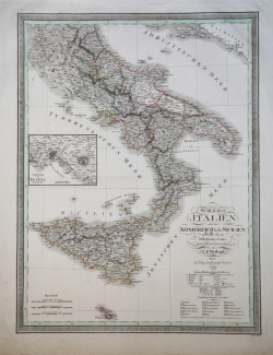
Large double page map of southern Italy & Sicily from 'Allgemeiner Hand-Atlas der Erde und des Himmels nach den besten astronomischen Bestimmungen...'. published by Geographisches Institut, Weimar.
|
Founded by friecrich Justin Bertuch in 1804 in Weimar, to engrave, print and publish both domestic and foreign geographical and cartographical publications including shool atlases, historical atlases, regional, world and special atlases. The Institut took over the publication of many of the maps first created and published by the Landes-Industrie Comptoir. Many important mapmakers worked for the company including: Gussefeld, August and Adolf Stieler, Heirich Hiepert ecc.
|
|
Founded by friecrich Justin Bertuch in 1804 in Weimar, to engrave, print and publish both domestic and foreign geographical and cartographical publications including shool atlases, historical atlases, regional, world and special atlases. The Institut took over the publication of many of the maps first created and published by the Landes-Industrie Comptoir. Many important mapmakers worked for the company including: Gussefeld, August and Adolf Stieler, Heirich Hiepert ecc.
|