
| Reference: | S48762 |
| Author | Abraham ORTELIUS |
| Year: | 1587 ca. |
| Zone: | Iceland |
| Printed: | Antwerpen |
| Measures: | 495 x 345 mm |
| Reference: | S48762 |
| Author | Abraham ORTELIUS |
| Year: | 1587 ca. |
| Zone: | Iceland |
| Printed: | Antwerpen |
| Measures: | 495 x 345 mm |
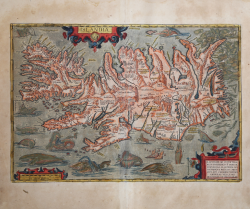
Title: ISLANDIA. At upper left: "Priuilegio Imp. et Belgico decennali | A. Ortel. excud. 1585". In the cartouche bottom right corner: ILLVSTRISS. AC POTENTISS. | REGI FREDERICO II DANIAE, | NORVEGIAE, SLAVORVM, GO:|THORVMQVE REGI, ETC. PRIN:|CIPI SVO CLEMENTISSIMO, | ANDREAS VELLEIVS | DESCRIBEB. ET DEDICABAT.
Fine example of Ortelius' classic map of Iceland, one of the most decorative atlas maps of all time and the first relatively accurate map of Iceland from indigenous sources.
The map depicts Iceland in remarkable detail, including its mountains, fjords, glaciers and a graphic depiction of Mount Hekla erupting in a fiery explosion of flames and volcanic material. Along part of the coastline, Polar Bears can be seen floating on icebergs. The map includes over 200 place names, primarily Danish in origin and many of which are likely misread from the original map, owing to the different writing style employed in Iceland during the period. While the map is far from accurate, it depicts first time a meaningful depiction of all known settlements in Iceland and many other points of interest, including a number of glaciers.
The map illustrates a remarkable array of the legendary and mythical sea monsters and creatures of the 15th and 16th Century, along with early depictions of the sea horse, manta ray, walrus and whale. Some of the more purely fanciful images may derive from tales of St. Brendan, a sixth century Irish missionary who, according to legend, journeyed to Iceland and whose name is associated with a mythical island of the same name. Others are traceable to Olaus Magnus's Carta Marina of 1539, although they were probably derived directly from Munster's Cosmographia of 1545 and most notably Munster's chart of the Sea and Land Creatures.
The dedication in the lower right corner notes that the map is drawn up and dedicated by Andreas Velleius to the Illustrious and powerful Frederic the Second, King of the Danes, Norwegians, Slavs, Goths etc., his most merciful Majesty. Andreas Sorensen Vedel (1542-1616) was an important Danish historian of the period who prepared, but apparently never published a treatise on history of Denmarke, which he had intended to illustrate with maps. However, it is almost certain that Vedel was not the maker of the map and simply transmitted the map to Ortelius, without mentioning its source.
The map is a vast improvement over all prior maps of Iceland and it is believed therefore that it could only have been drawn by an Icelander, most likely Gudbrandur Thorlaksson, Bishop of Holar, who studied mathematics and astronomy in Copenhagen. It is known that Thorlaksson made a map of the region in 1606. While no map of Iceland by Thorlaksson survives, there is other circumstantial evidence, including a list of churches and fjords which was available and perhaps prepared by Thorlakson, which were almost certainly used in preparing the map. While a privilege for the map was granted in 1585, Ortelius's version first appeared in an atlas in 1587, in the 'Additamentum IV', an appendix of 22 new maps not featured in the last full 'Theatrum Orbis Terrarum'.
Example of the second state according Van den Broecke, with key letters for monsters. From the Italian edition of 'Theatrum Orbis Terrarum', printed by Johann Baptiste Vrients in 1608.
A fine impressions on contemporary laid paper with full original colouring, very slight moisture stain at top, otherwise in very good condition.
Bibliografia
Campbell, Early Maps, pl. 40; Van Broeck 161; Moreland & Bannister p.93.
Abraham ORTELIUS (1528 - 1598)
|
Abraham Ortel, better known as Ortelius, was born in Antwerp and after studying Greek, Latin and mathematics set up his business there with his sister, as a book dealer and 'painter of maps'. Travelling widely, especially to the great book fairs, his business prospered and he established contacts with many sultured men in many lands. On one such visit to England, possibly seeking temporary refuge from religious persecution, he met William Camden whom he is said to have encouraged in the production of the Britannia.
A turning-point in his career was reached in 1564 with the publication of a World Map in eight sheets of which only one copy is known: other individual maps followed and then - at the suggestion of a friend - he gathered together a collection of maps from contacts among European cartographers and had them engraved in uniform size and issued in 1570 as the Theatrum Orbis Terrarum (Atlas of the Whole World). Although Lafreri and others in Italy had published collections of 'modern' maps in book form in earlier years, the Theatrum was the first uniformly sized, systematic collection of maps and hence can be called the first atlas, although that term itself was not used until twenty years later by Mercator.
The Theatrum, with most of its maps elegantly engraved by Frans Hogenberg, was an instant success and appeared in numerous editions in different languages including addenda issued from time to time incorporating the latest contemporary knowledge and discoveries. The final edition appeared in 1612. Unlike many of his contemporaries Ortelius noted his sources of information and in the first edition acknowledgement was made to eighty-seven different cartographers.
Apart from the modern maps in his major atlas, Ortelius himself compiled a series of historical maps known as the Parergon Theatri which appeared from 1579 onwards, sometimes as a separate publication and sometimes incorporated in the Theatrum.
1570 Theatrum Orbis Terrarum 1570-1612 Between these years the Theatrum was re-issued in 42 editions with 5 supplements with text in Latin, Dutch, German, French, Spanish, Italian and English. The English edition was published in 1606 by John Norton, the maps being printed in Antwerp and the text added in London. Three years later Ortelius died in 1598, his heirs transferred publication rights to Jan Baptiste Vrients who produced the posthumous editions until he died in 1612
1577-85 Spiegel der Werelt (8vo) Maps from the Theatrum, reduced in size, engraved by Philip Galle: text by Pieter Heyns. 6 editions with Dutch, French and Latin text. 1588-i 603 Epitome theatri orbis terrarum (12mo/8v0) 11 further editions of the smaller maps with an increasing number of maps with text also in Italian and English (1603). i6oi-i 2 7 further editions with improved engravings by Arsenius Brothers: text by Michel Coignet in Latin, French, German, Italian and English (1603). 1598-1724 Theatro del Mondo (4t0/12mo/24mo) 8 editions with Italian text; plates engraved in Italy.
1579-1606 Parergon Theatri The number of maps included in the Parergon increased from 4 in 1579 to 43 in 1606 with text in Latin, French, Italian, German and English (1606) 1624 Re-issued in Antwerp as a separate publication by Balthasar Moretus. This edition included a reproduction of the Peutinger table.
|