
| Reference: | S49238.128 |
| Author | Georg BRAUN & Franz HOGENBERG |
| Year: | 1575 ca. |
| Zone: | Alger |
| Printed: | Antwerpen & Cologne |
| Measures: | 495 x 350 mm |
| Reference: | S49238.128 |
| Author | Georg BRAUN & Franz HOGENBERG |
| Year: | 1575 ca. |
| Zone: | Alger |
| Printed: | Antwerpen & Cologne |
| Measures: | 495 x 350 mm |
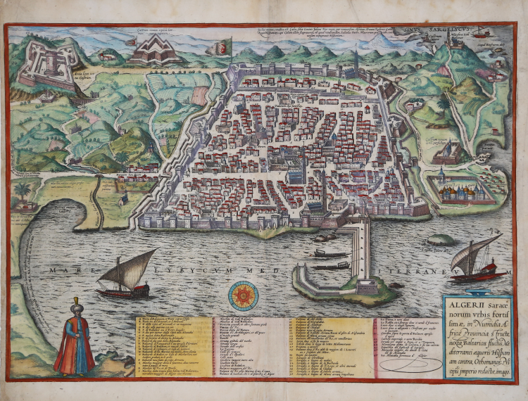
Bird’s-eye view plan of Algiers first published in the second volume of Civitates Orbis Terrarum, edited in 1575.
This is a close copy of an earlier model, recently identified in Bifolco-Ronca: “Si tratta di una grande pianta, stampata su quattro fogli uniti, pubblicata a Venezia nel 1573, con privilegio pontificio decennale, e privilegio ventennale del Senato di Venezia e di Alfonso a Stuniga. Il lungo cartiglio, che contiene la dedica a Filippo II di Spagna, esplicita che l’immagine di Algeri e quella disegnata da Ioannes Paciceus (it. Giovanni Pacheco), e accresciuta e corretta da Alfonsus a Stuniga (it. Alfonso Zuniga, o Zunica, Sunica, de Stuniga), Hispanus, ovvero spagnolo anche lui come Pacheco. Riguardo il Pacheco, presso l’Archivio di Stato di Mantova e conservato un interessante e prezioso documento: la lettera che Giovanni Pacheco, in data 6 ottobre 1571 invia al principe di Mantova Vincenzo Gonzaga, per accompagnare il dono dell’incisione di Algeri. La data, dunque, costituisce il terminus ante quem dell’opera. Non abbiamo reperito alcuna notizia circa Alfonso Zuniga. Presumiamo che appartenga alla famiglia Zunica che, originaria della Spagna, fu portata a Napoli nel 1514 da Cristofaro Zuniga. La famiglia nobiliare si divide poi in molti rami. Si ha notizia di un Alfonso Zuniga, capitano di cavalleria, che nel 1532 ottenne in dono il feudo di Pescomaggiore e di Felitto per aver sedato la rivolta dei cittadini aquilani contro gli spagnoli. (cfr. Candida Gonzaga, Memorie delle Famiglie Nobili delle Provincie Meridionali d’Italia, vol 2, p. 210; e P. Cavallo, La Storia dietro gli scudi, vol. 3 – s. v. Zunica). La veduta e molto ricca di dettagli e precisa nelle indicazioni; senza dubbio si tratta della rappresentazione più completa di Algeri del XVI secolo, non sorprende, quindi, che diventerà il modello iconografico di tutta la produzione successiva, da Duchetti-Brambilla, a Cartaro, a Florimi. Lo stesso modello, di formato ridotto, e pubblicato da Braun & Hogenberg nel secondo libro (1575) del Civitates Orbis Terrarum, che ricalca solo la rubrica in italiano. Monchicourt, che evidentemente non conosceva questa grande veduta dello Stunica, a proposito di Algeri di Braun & Hogenber, aveva avanzato l’ipotesi che questa - o un’altra pianta analoga - potesse essere uno dei due “disegni” di Algeri – “uno a mano, et l’altro stampato” - che i cavalieri Francesco Lanfreducci e Gian Ottone Bosio, dichiarano di aver utilizzato per il loro rapporto presentato al Gran Maestro di Malta nel 1587. Infatti, nessuno dei due aveva mai visitato Algeri, pertanto il rapporto, come da loro stessi dichiarato, era un’opera di compilazione basata a partire dai racconti dei prigionieri corredata da due piante che si trovavano allegate alla relazione, ma che sono andate smarrite. La città e rappresentata in forma di trapezio, con il lato più lungo parallelo alla linea di costa. Lungo gli altri tre lati, un fossato pieno d’acqua costeggia le mura interrotte, a intervalli regolari, da torri quadrate e, nei punti strategicamente più importanti, da bastioni a forma di cuneo. A partire dall’angolo di destra, e seguendo le mura dal lato di terra, si incontra: il Baluardo de Baluet (cioe il Bastione di Bāb al-Wěd); il Baluardo Novo eretto da da Yahyā Raīs: i due baluardi nuovi della Alcazaba, ed il baluardo di Bāb’Azūn nell’angolo opposto a quello di Baluet. Dalla parte del mare si trovano il baluardo di Cochiaperi e quello della Marina. Ben visibili sono anche le porte turrite dell’arsenale, comprese tra questi due bastioni. Nell’agglomerato urbano, si distinguono cinque moschee. La qasba, Alcazaba, e rappresentata nella parte superiore della città, separata dal resto della città da un muro. Molto accurata e l’immagine del Palazzo del Re, e della rete viaria, coi nomi delle strade che si riferiscono alle varie attività commerciali esercitate, cosi troviamo la “strada degli orefici”, la strada d’i spadari” ecc. All’esterno delle mura, si distinguono tre fortezze, diverse per forma e importanza: il Castello imperiale, o vero Burchio, vicino al quale si eleva il Castello Nuovo, in forma di stella; infine, un Castrum novum anno 1569 perfectum” (cfr. Cartografia e topografia italiana del XVI secolo, 2018, pp. 476-479).
The Civitates Orbis Terrarum, is the first six-volume atlas devoted to town views and plans ever published.
The first volume of the Civitates Orbis Terrarum was published in Cologne in 1572. The sixth and the final volume appeared in 1617. This great city atlas, edited by Georg Braun and largely engraved by Franz Hogenberg, eventually contained 546 prospects, bird-eye views and map views of cities from all over the world. Fransz Hogenberg produced the plates for the first four books, and Simon van den Neuwel (Novellanus, active since 1580) those for volumes V and VI.
Georg Braun (1541-1622), a cleric of Cologne, was the principal editor of the work, and was greatly assisted in his project by the close, and continued interest of Abraham Ortelius, whose Theatrum Orbis Terrarum of 1570 was, as a systematic and comprehensive collection of maps of uniform style, the first true atlas. The Civitates, indeed, was intended as a companion for the Theatrum, as indicated by the similarity in the titles and by contemporary references regarding the complementary nature of two works. Nevertheless, the Civitates was designs to be more popular in approach, no doubt because the novelty of a collection of city plans and views represented a more hazardous commercial undertaking than a world atlas, for which there had been a number of successful precedents. Franz Hogenberg (1535-1590) was the son of a Munich engraves who settled in Malines. He engraved most of the plates for Ortelius's Theatrum and the majority of those in the Civitates and may have been responsible for originating the project.
Over a hundred different artists and cartographers, the most significant of whom was Antwerp artist Georg Hoefnagel (1542-1600), engraved the cooper-plates of the Civitates from drawings. He not only contributed most of the original material for the Spanish and Italian towns but also reworked and modified those of other contributors. After Hoefnagel's death his son Jakob continued the work for the Civitates.
The author set out to depict "non icones et typi urbium," that is, not generic and typified images, "sed urbes ipsae admirabili caelaturae artificio, spectantium oculis subiectae appareant": not intended to allude or idealize but to represent faithfully on paper, to reproduce exactly, and in real time, what the eye sees, as announced in the preface to the first volume of Civitates Orbis Terrarum.
Engraving with fine hand colour, in very good condition.
Bibliografia
Van der Krogt IV, 2, 1, 73.
|
George Braun (1541-1622), cleric of Cologne, was the principal editor of the Civitates Orbis Terrarum, and was greatly assisted in his project by the close, and continued interest of Abraham Ortelius, whose Theatrum Orbis Terrarum of 1570 was, as a systematic and comprehensive collection of maps of uniform style, the first true atlas.
Franz Hogenberg (1535-1590) was the son of a Munich engraves who settled in Malines. He engraved most of the plates for Ortelius's Theatrum and the majority of those in the Civitates, and may have been responsible for originating the project.
|
|
George Braun (1541-1622), cleric of Cologne, was the principal editor of the Civitates Orbis Terrarum, and was greatly assisted in his project by the close, and continued interest of Abraham Ortelius, whose Theatrum Orbis Terrarum of 1570 was, as a systematic and comprehensive collection of maps of uniform style, the first true atlas.
Franz Hogenberg (1535-1590) was the son of a Munich engraves who settled in Malines. He engraved most of the plates for Ortelius's Theatrum and the majority of those in the Civitates, and may have been responsible for originating the project.
|