| Reference: | S46104 |
| Author | Abraham ORTELIUS |
| Year: | 1590 ca. |
| Zone: | Africa |
| Printed: | Antwerpen |
| Measures: | 480 x 335 mm |
| Reference: | S46104 |
| Author | Abraham ORTELIUS |
| Year: | 1590 ca. |
| Zone: | Africa |
| Printed: | Antwerpen |
| Measures: | 480 x 335 mm |
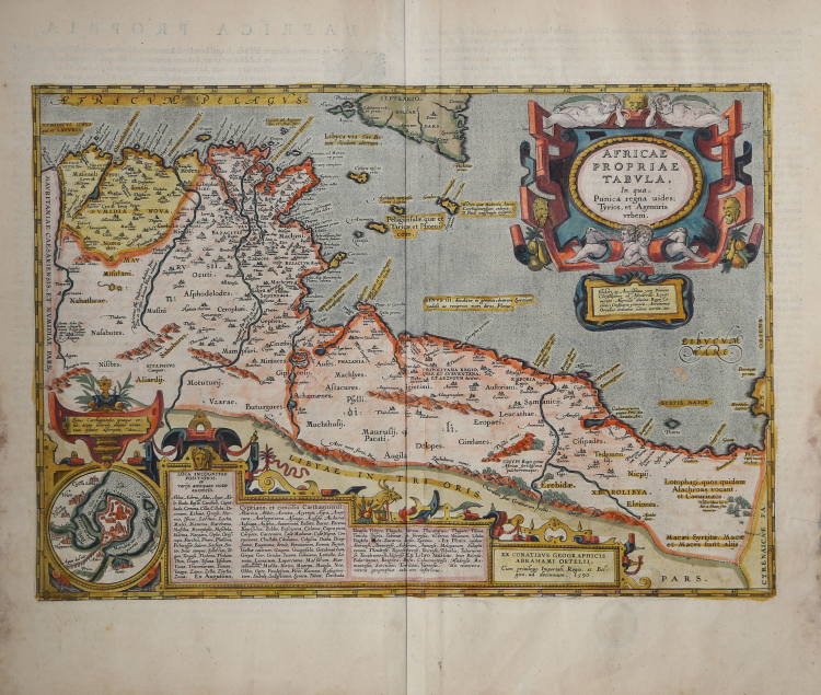
Splendid historical map of the ancient Carthaginian kingdom, published in Abraham Ortelius' Parergon.
This attractive, richly detailed map focuses on the ancient Carthaginian kingdom at the time of the Punic wars. The map covers the north African coast from Algeria to Libya, centering on Tunisia and the archipelago between Africa and Sicily; Malta is shown prominently. An inset plan shows the city and harbor of Carthage prior to its destruction.
Example from the rare Italian edition of Theatrum Orbis Terrarum printed in Antwerp by Jean Baptiste Vrients in 1608 and then in 1612. Example of the first state.
Title: AFRICAE | PROPRIAE | TABVLA, | "In qua", | Punica regna vides;| Tyrios, et Agenoris | urbem. | "Illustri ac Amplissimo viro Domino | Christophoro ab Assonleville: Equiti | aurato; Altevillæ domino: Regis Ca:|tholici Consiliario primario. Abrahamus | Ortelius dedicabat, lubens merito". [A map of Africa proper, on which you see the Punic kingdom, Tyrios and the city of Agenor. Dedicated to the illustrious and honourable gentleman lord Christophorus from Assonleville. Honoured knight, ruler of Altevilla, first councillor of our catholic king, by Abraham Ortelius because of his great merits]. Cartouche lower right: EX CONATIBVS GEOGRAPHICIS | ABRAHAMI ORTELII.| "Cum priuilegio Imperiali, Regio, et Bel:|gico, ad decennium. 1590". [From the geographical efforts of Abraham Ortelius. With an imperial, Royal and Belgian privilege for ten years. 1590]. Cartouche bottom centre: three colums of placenames of uncertain location). (Inset:) "Sinus Carthaginensis, ipsæque ur:|bis, atque locorum aliquot vicino:|rum plenior descriptio". [A full depiction of the Carthago gulf, the city of Carthago, and of some places in the vicinity]. (Upper centre:) "Melita, quæ Maltaria Anton. | Carthaginensium colonia. | D. Pauli naufragio insignis". [The isle of Melita, Antoninus calls it Maltaria. It became famous because of the shipwreck of St. Paulus]. Centre: Sinus III, "diuiditur in geminos; duarum Syrtium | vadoso ac reciproco mari diros. Plinius". [The third gulf is divided into two parts; of these two the Syrtian sea is full of shallow places, and at ebb tide very dangerous]. Lower right: CINYPS "Regio totius | Africæ fertilißima | pulcherrimaque". [Cynips, the most fertile and beautiful region of Africa]. (Lower right:) Lotophagi, quos quidam | Alachroas vocant. | et Camarinæos. [The Lotos-eaters, by some called Alachroæ and also Camarinei.] Lower right: "Hesperidum horti, | hic à Plinio sta:|tuuntur". [The gardens of the Hesperides are placed here by Plinius]. Lower right: Macæi Syrtitæ. Macæ | et Maces sunt alijs. [The Syrtitian Macæi. The Macæ and Maces are different people]. More text blocks in Topographical Names.
Made by Ortelius on the basis of modern information from Gastaldi's Africa map (Meurer p. 87-88, p. 151) and ancient knowledge from Diodorus Siculus, Plinius, Vergilius, Appianus, Halicarnasseus, Athenæus and Herodotos. Bertius bought a number of sheets with this map and included the map in his historical 1618 atlas "Theatrum Geographiæ Veteris", using the text of the 1609/1612S/Latin ed. The extensive text deals mostly with the city of Carthago (see text) and its final destruction by the Romans.
The Parergon is the first historical atlas ever published. It was initially conceived by Ortelius as an appendix to his Theatrum Orbis Terrarum but given the considerable success of these historical maps it later became an independent work and remained the main source of all similar works throughout the seventeenth century.
Koeman wrote: “This atlas of ancient geography must be regarded as a personal work of Ortelius. For this work he did not, as in the Theatrum, copy other people's maps but drew the originals himself... He took many places and regions from the lands of classical civilization to illustrate and clarify their history, a subject very close to his heart... The maps and plates of the Parergon have to be evaluated as the most outstanding engravings depicting the wide-spread interest in classical geography in the 16th century."
The Theatrum Orbis Terrarum, which is considered the first true modern "Atlas". The work was published in 7 languages and 36 editions, for which - in 1570 - Ortelius obtained the privilege, a kind of copyright that prevented other cartographers from publishing his works. The Theatrum represented the most advanced work of cartographic description. Ortelius collected in it the geographical and cartographic knowledge of his time, proposing in 147 spectacular engraved plates the most faithful image of the world then known and, in some extraordinary "historical maps", regions and routes taken from literature, mythology, tradition.
Example with magnificent contemporary coloring, paper slightly browned, otherwise in excellent condition.
Bibliografia
Cfr. L. Bagrow, A. Ortelli Catalogus Cartographorum; cfr. C. Koeman, Atlantes Neerlandici; Peter H. Meurer, Fontes Cartographici Orteliani 14p; M. Van den Broecke, Ortelius Atlas Maps, n. 218 I/II; Van der Krogt, Koeman’s Atantes Neerlandici: 8610H:31.
Abraham ORTELIUS (1528 - 1598)
|
Abraham Ortel, better known as Ortelius, was born in Antwerp and after studying Greek, Latin and mathematics set up his business there with his sister, as a book dealer and 'painter of maps'. Travelling widely, especially to the great book fairs, his business prospered and he established contacts with many sultured men in many lands. On one such visit to England, possibly seeking temporary refuge from religious persecution, he met William Camden whom he is said to have encouraged in the production of the Britannia.
A turning-point in his career was reached in 1564 with the publication of a World Map in eight sheets of which only one copy is known: other individual maps followed and then - at the suggestion of a friend - he gathered together a collection of maps from contacts among European cartographers and had them engraved in uniform size and issued in 1570 as the Theatrum Orbis Terrarum (Atlas of the Whole World). Although Lafreri and others in Italy had published collections of 'modern' maps in book form in earlier years, the Theatrum was the first uniformly sized, systematic collection of maps and hence can be called the first atlas, although that term itself was not used until twenty years later by Mercator.
The Theatrum, with most of its maps elegantly engraved by Frans Hogenberg, was an instant success and appeared in numerous editions in different languages including addenda issued from time to time incorporating the latest contemporary knowledge and discoveries. The final edition appeared in 1612. Unlike many of his contemporaries Ortelius noted his sources of information and in the first edition acknowledgement was made to eighty-seven different cartographers.
Apart from the modern maps in his major atlas, Ortelius himself compiled a series of historical maps known as the Parergon Theatri which appeared from 1579 onwards, sometimes as a separate publication and sometimes incorporated in the Theatrum.
1570 Theatrum Orbis Terrarum 1570-1612 Between these years the Theatrum was re-issued in 42 editions with 5 supplements with text in Latin, Dutch, German, French, Spanish, Italian and English. The English edition was published in 1606 by John Norton, the maps being printed in Antwerp and the text added in London. Three years later Ortelius died in 1598, his heirs transferred publication rights to Jan Baptiste Vrients who produced the posthumous editions until he died in 1612
1577-85 Spiegel der Werelt (8vo) Maps from the Theatrum, reduced in size, engraved by Philip Galle: text by Pieter Heyns. 6 editions with Dutch, French and Latin text. 1588-i 603 Epitome theatri orbis terrarum (12mo/8v0) 11 further editions of the smaller maps with an increasing number of maps with text also in Italian and English (1603). i6oi-i 2 7 further editions with improved engravings by Arsenius Brothers: text by Michel Coignet in Latin, French, German, Italian and English (1603). 1598-1724 Theatro del Mondo (4t0/12mo/24mo) 8 editions with Italian text; plates engraved in Italy.
1579-1606 Parergon Theatri The number of maps included in the Parergon increased from 4 in 1579 to 43 in 1606 with text in Latin, French, Italian, German and English (1606) 1624 Re-issued in Antwerp as a separate publication by Balthasar Moretus. This edition included a reproduction of the Peutinger table.
|