
| Reference: | S29374 |
| Author | Sebastian Münster |
| Year: | 1550 ca. |
| Zone: | Naples |
| Printed: | Basle |
| Measures: | 185 x 135 mm |
| Reference: | S29374 |
| Author | Sebastian Münster |
| Year: | 1550 ca. |
| Zone: | Naples |
| Printed: | Basle |
| Measures: | 185 x 135 mm |
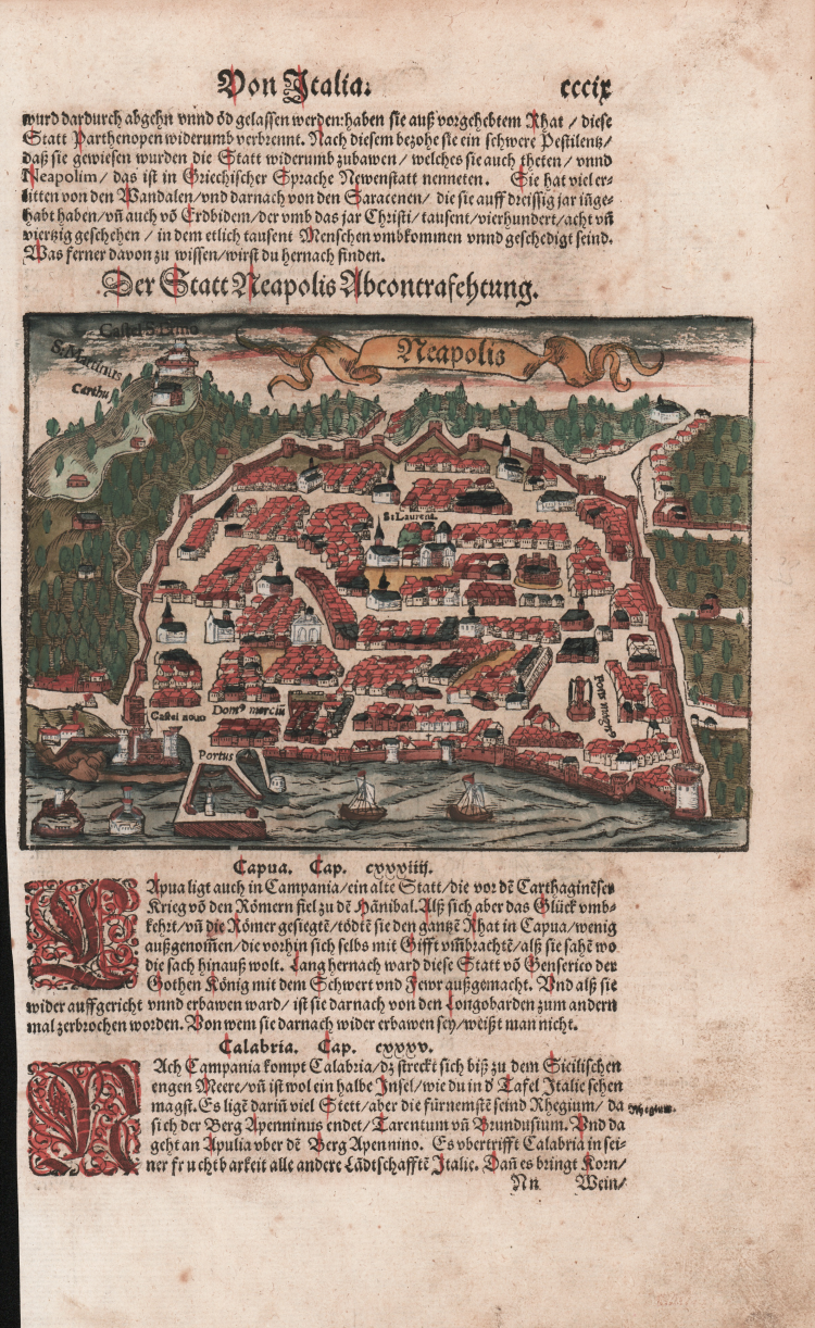
First printed map of Naples, from Cosmographiae Universalis by Sebastian Münster, German edition, Basel, second half of the 16th Century.
“Sebbene l'impianto grafico sia di dimensioni ridotte (13x18 cm) la pianta risulta eseguita con una certa scrupolosità, e certamente è stata disegnata sul luogo. Malgrado alcune necessarie semplificazioni e stilizzazioni grafiche, essa presenta alcune caratteristiche degne di essere menzionate. Come ha sottolineato Giulio Pane, ad esempio, “è veramente meritevole di attenzione l'andamento delle mura aragonesi, con le sue sporgenze e rientranze”; evidenti sono il torrione del Carmine (il Trono, detto anche Torre Spinella), nell'angolo sud-orientale, ed un'imponente porta affiancata da due torri (Porta Capuana, con l'Onore e la Virtù) che si apre sul largo asse viario extraurbano, che conduce a Poggio Reale e Capua. Anche nell'area del porto sono segnalate le principali emergenze urbane, quali l'isolata torre San Vincenzo, il molo con la lanterna, i due bracci orientali dell'arsenale e la murazione lungo il mare, fino a raggiungere il Carmine. I toponimi sono pochi ma significativi: "Castel novo", "Dom[us] merciu[m]", ove era il fondaco di età aragonese, alle spalle del "Portus", "S: Laurent" a marcare il centro politico della città ed un "Fons magn[us]" che campeggia nella piazza del mercato e che, descritta nella cronaca del Ferrajolo del secolo precedente, rimarrà una costante nell'iconografia urbana della Napoli del Cinquecento. Di un certo interesse è anche il tracciato occidentale delle mura edificate nel corso degli ultimi anni di regno aragonese, portato a compimento da Ferdinando il Cattolico. Parte di questo tratto andò distrutto dagli interventi di don Pedro di Toledo per la costruzione dell'arteria viaria e degli acquartieramenti spagnoli. Lungo il perimetro occidentale è anche identificabile la primitiva Porta Reale, dalla quale si diparte una strada che sale lungo le pendici della collina, ancora leggibile nel suo sinuoso percorso nella successiva pianta del Du Pérac. Nettamente delineata è la porta di Santo Spirito, a settentrione del Castel Nuovo. Nella pianta, la cui datazione va a collocarsi nella prima metà del Cinquecento, la città risulta tutta interamente racchiusa nella murazione concepita verso il 1480 con l'intento di includere le nuove aree urbanizzate al di fuori della cortina angioina, quali San Giovanni a Carbonara ad oriente e Monteoliveto e Sant'Agnese (attuale via Santa Brigida) ad occidente. Fuori dalla cinta muraria sono indicati tre toponimi sulla collina che sovrasta la città: "S: Martinus", "Carthusia" (la Certosa) e "Castel S: Ermo", suben-trato quest'ultimo al più antico Belforte” /cfr. Vladimiro Valerio in Piante e vedute di Napoli dal 1486 al 1599, p. 26).
The Cosmographiae Universalis of Sebastian Münster (1488-1552), printed for the first time in Basel in 1544 by the publisher Heinrich Petri, was updated several times and increased with new maps and urban representations in its many editions until the beginning of the next century. Münster had worked to collect information in order to obtain a work that did not disappoint expectations and, after a further publication in German embellished with 910 woodblock prints, arrived in 1550 to the final edition in Latin, illustrated by 970 woodcuts.
There were then numerous editions in different languages, including Latin, French, Italian, English and Czech. After his death in Münster (1552), Heinrich Petri first, and then his son Sebastian, continued the publication of the work. The Cosmographia universalis was one of the most popular and successful books of the 16th century, and saw as many as 24 editions in 100 years: the last German edition was published in 1628, long after the author's death. The Cosmographia contained not only the latest maps and views of all the most famous cities, but also a series of encyclopedic details related to the known, and unknown, world.
The particular commercial success of this work was due in part to the beautiful engravings (among whose authors can be mentioned Hans Holbein the Younger, Urs Graf, Hans Rudolph Manuel Deutsch, David Kandel).
Woodcut, beautiful original hand-coloring, very good condition.
Sebastian Münster (1488 - 1552)
|
Sebastian Münster was a German cartographer, cosmographer, and Hebrew scholar whose Cosmographia (1544; "Cosmography") was the earliest German description of the world and a major work - after the Nuremberg Chronicle of 1493 - in the revival of geography in the 16th-century Europe. Altogether, about 40 editions of the Cosmographia appeared during 1544-1628. Although other cosmographies predate Münster's, he is given first place in historical discussions of this sort of publication, and was a major influence on his subject for over 200 years.
In nearly all works by Münster, his Cosmographia is given pride of place. Despite this, we still lack a detailed survey of its contents from edition to edition, along the years from 1544 to 1628, and an account of its influence on a wide range of scientific disciplines. Münster obtained the material for his book in three ways. He used all available literary sources. He tried to obtain original manuscript material for description of the countryside and of villages and towns. Finally, he obtained further material on his travels (primarily in south-west Germany, Switzerland, and Alsace). The Cosmographia contained not only the latest maps and views of many well-known cities, but included an encyclopaedic amount of details about the known - and unknown - world and undoubtedly must have been one of the most widely read books of its time.
Aside from the well-known maps and views present in the Cosmographia, the text is thickly sprinkled with vigorous woodcuts: portraits of kings and princes, costumes and occupations, habits and customs, flora and fauna, monsters and horrors. The 1614 and 1628 editions of Cosmographia are divided into nine books. Nearly all the sections, especially those dealing with history, were enlarged. Descriptions were extended, additional places included, errors rectified.
|