
| Reference: | VR66FR |
| Author | Dépôt des cartes et plans de la Marine |
| Year: | 1785 |
| Zone: | Mediterranean Sea |
| Printed: | Paris |
| Measures: | 1070 x 545 mm |
| Reference: | VR66FR |
| Author | Dépôt des cartes et plans de la Marine |
| Year: | 1785 |
| Zone: | Mediterranean Sea |
| Printed: | Paris |
| Measures: | 1070 x 545 mm |
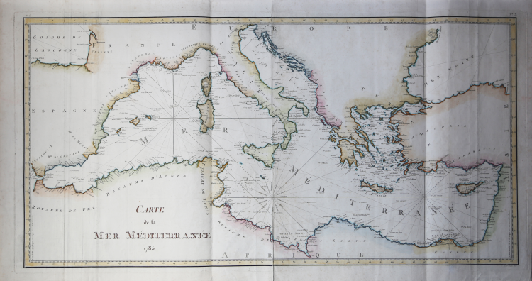
Etching, printed on two sheets.
Signed on the plate in the lower right corner by the name of the engraver L. A. Dupuis Sculp.
Beautiful example, finely colored by hand.
Taken from: Hydrographie Françoise compiles general and particular maps that have been made for the service of the Roy's vessels.
The chart is printed by order of Joseph Bernard de Chabert, from the Depot of maps and plans of the Marine, engraved by Louis André Dupuis in 1785. Joseph Bernard, Marquis of Chabert de Cogolin (Toulon 1724-1805), was an officer of navy, geographer and astronomer, director of the Depot des cartes et plans de la Marine from 1776 to 1792. The chart is part of the famous Hydrographie Françoise, the most important nautical Atlas of the '700 - started at the will of Jacques-Nicola Bellin - and printed under the direction of the Depot of Maps and Marine Plans.
Bibliografia: cfr. O. Chapuis, A la mer comme au ciel: Beautemps-Beaupré & la naissance de lhydrographie, Parigi, 1999, pp. 151-4; cfr. National Maritime Museum, Catalogue of the Library - Vol. Three, Atlas & Cartography, Londra, 1971, pp. 306, n. 254 VI (176-178).
|
S. Bifolco, "Mare Nostrum, Cartografia nautica a stampa del Mar Mediterraneo" (2020), pp. 284-285, tav. 134.
|
Dépôt des cartes et plans de la Marine
|
The Dépôt de la Marine, known more formally as the Dépôt des cartes et plans de la Marine, was the central charting institution of France. The centralization of hydrography in France began in earnest when Jean-Baptiste Colbert became First Minister of France in 1661. Under his watch, the first Royal School of Hydrography began operating, as did the first survey of France’s coasts (1670-1689). In 1680, Colbert consolidated various collections of charts and memoirs into a single assemblage, forming the core of sources for what would become the Dépôt.
The Dépôt itself began as the central deposit of charts for the French Navy. In 1720, the Navy consolidated its collection with those government materials covering the colonies, creating a single large repository of navigation. By 1737, the Dépôt was creating its own original charts and, from 1750, they participated in scientific expeditions to determine the accurate calculation of longitude.
In 1773, the Dépôt received a monopoly over the composition, production, and distribution of navigational materials, solidifying their place as the main producer of geographic knowledge in France. Dépôt-approved charts were distributed to official warehouses in port cities and sold by authorized merchants. The charts were of the highest quality, as many of France’s premier mapmakers worked at the Dépôt in the eighteenth century, including Philippe Bauche, Jacques-Nicolas Bellin, Rigobert Bonne, Jean Nicolas Buache, and Charles-François Beautemps-Beaupré.
The Dépôt continued to operate until 1886, when it became the Naval Hydrographic Service. In 1971, it changed names again, this time to the Naval and Oceanographic Service (SHOM). Although its name has changed, its purpose is largely the same, to provide high quality cartographic and scientific information to the France’s Navy and merchant marine.
|
|
S. Bifolco, "Mare Nostrum, Cartografia nautica a stampa del Mar Mediterraneo" (2020), pp. 284-285, tav. 134.
|
Dépôt des cartes et plans de la Marine
|
The Dépôt de la Marine, known more formally as the Dépôt des cartes et plans de la Marine, was the central charting institution of France. The centralization of hydrography in France began in earnest when Jean-Baptiste Colbert became First Minister of France in 1661. Under his watch, the first Royal School of Hydrography began operating, as did the first survey of France’s coasts (1670-1689). In 1680, Colbert consolidated various collections of charts and memoirs into a single assemblage, forming the core of sources for what would become the Dépôt.
The Dépôt itself began as the central deposit of charts for the French Navy. In 1720, the Navy consolidated its collection with those government materials covering the colonies, creating a single large repository of navigation. By 1737, the Dépôt was creating its own original charts and, from 1750, they participated in scientific expeditions to determine the accurate calculation of longitude.
In 1773, the Dépôt received a monopoly over the composition, production, and distribution of navigational materials, solidifying their place as the main producer of geographic knowledge in France. Dépôt-approved charts were distributed to official warehouses in port cities and sold by authorized merchants. The charts were of the highest quality, as many of France’s premier mapmakers worked at the Dépôt in the eighteenth century, including Philippe Bauche, Jacques-Nicolas Bellin, Rigobert Bonne, Jean Nicolas Buache, and Charles-François Beautemps-Beaupré.
The Dépôt continued to operate until 1886, when it became the Naval Hydrographic Service. In 1971, it changed names again, this time to the Naval and Oceanographic Service (SHOM). Although its name has changed, its purpose is largely the same, to provide high quality cartographic and scientific information to the France’s Navy and merchant marine.
|