| Reference: | VR31OL |
| Author | Romeyn de Hooghe |
| Year: | 1694 |
| Zone: | Mediterranean Sea |
| Printed: | Amsterdam |
| Measures: | 1390 x 585 mm |
| Reference: | VR31OL |
| Author | Romeyn de Hooghe |
| Year: | 1694 |
| Zone: | Mediterranean Sea |
| Printed: | Amsterdam |
| Measures: | 1390 x 585 mm |
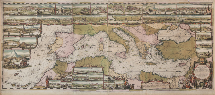
Carte Nouvelle De La Mer Mediterranee ou sont Exactement Remarques tous les Ports, Golfes, Rochers, Banks, de Sable &c: a l’usage des Arméès, du Roy de la Grande Bretagne. Dressé sur le Memoires les Plus Nouveaux par le Sr. Romain de Hooge.
Etching and engraving, 585x1390, signed in the lower cartouche with the imprint: A Amsterdam chez Pierre Mortier. Avec Privilége 1694.
RARE FIRST STATE, of four, dated 1694, before the correction of the title.
Magnificient example with fine original colouring, in excellent condition.
The map is embellished with 38 inset maps and views of the major ports and harbors of the Meditereanean Sea, and numeorus galleons, allegorical figures and sea monsters.
From: Cartes Marines a l'Usage des Armées du Roy de la Grande Bretagne: Faites sur les Memoires les plus nouveaux, des plus experts Ingenieurs et Pilotes, et enrichies des porfils des plus fameaux Ports de Mer et villes Maritimes de l'Europe. (…) Gravéès et recuillies par le Sr. Romain De Hooge Commissaire de Sa Majesté. A Amsterdam. Chez Pierre Mortier Libraire sur le Vygen Dam. M.DC. LXXXXIII. Avec Privilege de Nos Seigneurs les Etats de Hollande et West-Frise. This chart is the most decorative map of the Mediterranean issued for inclusion in an atlas.
This beautiful map is included in a special section of the Neptune François by Pierre Mortier, titled Cartes Marines a l’Usage des Armées du Roy de la Grande Bretagne, that contains maps engraved by de Hooghe; these charts were judged by Koeman to be the most spectacular type of maritime cartography ever produced.
According to Koeman the Neptune François was: …the most expensive sea-atlas ever published in Amsterdam.. Its charts are larger and more lavishly decorated than those of any preceding book of this kind. For the engraving and etching Mortier had recruited the most qualified artists. This magnificent work was intended more as a show piece than something to be used by pilots at sea.
Bibliografia: T. Campbell, Early Maps, New York, 1981, pp. 96-7; C. Koeman, Atlantes Neerlandici: Bibliography of Terrestrial, Maritime and Celestial Atlases and Pilot Books Published in the Netherlands up to 1880 Vol. IV, pp. 423-431, M. Mor 5 (9); Mare Nostrum, a historic voyage across the Mediterranean Sea, Lussemburgo, 2003, p. 38; National Maritime Museum, Catalogue of the Library - Vol. Three, Atlas & Cartography, Londra, 1971, pp. 282-284, n. 238 (38); R. Putman, Early Sea Charts, New York, 1983, pp. 22-3, tav. 7; cfr. R. Shirley, Maps in the Atlases of the British Library, Londra, 2004, pp. 1236-1241; P. Whitfield, The Charting of the Oceans: Ten Centuries of Maritime Maps, British Library, 1996, pp. 86-7.
|
S. Bifolco, "Mare Nostrum, Cartografia nautica a stampa del Mar Mediterraneo" (2020), pp. 158-159, tav. 68.
|
Romeyn de Hooghe
|
S. Bifolco, "Mare Nostrum, Cartografia nautica a stampa del Mar Mediterraneo" (2020), pp. 158-159, tav. 68.
|
Romeyn de Hooghe