
| Reference: | S45920 |
| Author | Istituto Geografico Visceglia |
| Year: | 1940 |
| Zone: | Mediterranean Sea |
| Printed: | Rome |
| Measures: | 970 x 690 mm |
| Reference: | S45920 |
| Author | Istituto Geografico Visceglia |
| Year: | 1940 |
| Zone: | Mediterranean Sea |
| Printed: | Rome |
| Measures: | 970 x 690 mm |
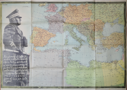
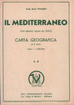
Grande carta del Mediterraneo con annessa figura di Benito Mussolini.
Si tratta di un’opera di propaganda fascista disegnata dal celebre cartografo Vincenzo Visceglia, fondatore dell’Istituto Geografico Visceglia. La carta viene pubblicata del 1940, quale supplemento della Guida Toponomastica Visceglia.
La Visceglia è una storica casa editrice italiana di carte geografiche. Fu fondata dal Prof. Vincenzo Visceglia, nel 1929. Nel 1930 viene realizzata la prima pubblicazione dell'istituto: la Guida toponomastica di Roma, planimetria della città, suddivisa in tavole e con la segnalazione dei numeri civici. Durante gli anni Sessanta vengono pubblicate le planimetrie aggiornate dei capoluoghi di provincia, la cui raccolta costituisce l'Atlante urbanistico d'Italia.
Litografia a colori, più volte ripiegata ad astuccio, in perfetto stato di conservazione. Rara.
|
Italian editor and cartographer.
He began his engineering studies at the University of Naples. After moving to Rome, he graduated in physics and mathematics in 1928 and began a short period of teaching. He directs his interest towards geography in a more specific way, an interest that culminates with the foundation in 1929 of the Istituto Geografico Visceglia.
|
|
Italian editor and cartographer.
He began his engineering studies at the University of Naples. After moving to Rome, he graduated in physics and mathematics in 1928 and began a short period of teaching. He directs his interest towards geography in a more specific way, an interest that culminates with the foundation in 1929 of the Istituto Geografico Visceglia.
|