| Reference: | S30814 |
| Author | Claudio DUCHET (Duchetti) |
| Year: | 1585 ca. |
| Zone: | Ancona |
| Printed: | Venice |
| Measures: | 550 x 330 mm |
| Reference: | S30814 |
| Author | Claudio DUCHET (Duchetti) |
| Year: | 1585 ca. |
| Zone: | Ancona |
| Printed: | Venice |
| Measures: | 550 x 330 mm |
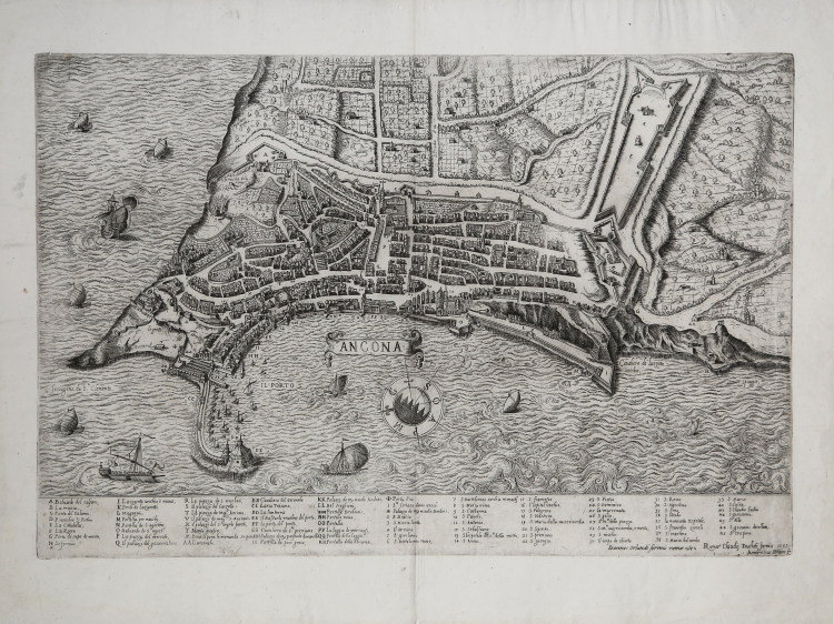
Perspective plan of the city of Ancona engraved by Ambrogio Brambilla for the publisher Claudio Duchetti. This is a replica, in a reduced format, of the work of Giacomo Fontana. The only changes are the absence of the cartouche with the dedication, at the top right, replaced by two schooners, and the addition of three entries in the legend. Grandson of Antonio Lafrery, Claude Duchet or Duchetti inherited the cartographic heritage in plates and continued the activity of publisher of his uncle, who died in 1577, increasing the series of plants and maps in print. Duchetti commissioned his main collaborator, the Milanese engraver Ambrogio Brambilla, to make a copy of Fontana's map, of which he lost possession in the hereditary division between him and his cousin Stefano. The work was printed for the first time in the year of Claudio Duchetti's death (1585) and the plate was inherited by Giacomo Gherardi.
Etching and engraving, 1585, signed on the plate by the publisher. Specimen of the second state of two bearing the address of Giovanni Orlandi, and the date Rome 1602.
Magnificent proof, printed on contemporary laid paper, with margins, in excellent condition.
Bibliografia
Bifolco-Ronca, Cartografia e topografia italiana del XVI secolo, p. 2120, tav. 1075, II/II; Bonasera (1979): p. 87, n. 17; Cartografia Rara (1986): n. 7; Christie’s (1998): n. 1078; Christie’s (2012): n. 54; Destombes (1970): n. 67; Ganado (1994): II, n. 94 & III, n. 119 & VI, n. 65 & p. 213, n. 57; Shirley (2004): III, n. 3; Sotheby’s (2000): n. 238; Marinelli (1902): p. 160; Pagani (2012): p. 82; cfr. Rubach (2016): p. 264; Tooley (1939): nn. 107, 109; Tooley (1983): n. 109a.
Claudio DUCHET (Duchetti) (Attivo a Roma nella seconda metà del XVI sec.))
|
Print dealer and publisher.Active in Venice 1565-1572 and Rome.He was the brother of Francesco Duchetti and a nephew of Antonio Lafrery, inheriting half his plates.
Died 5 December 1585.He was buried in San Luigi dei Francesi.By the terms of his will, his brother –in-law Giacomo Gherardi was to run the business until the majority of Claudio’s son, Claudio.
While Gherardi in charge, he was to inscribe the prints ‘haeredes Claudii Duchetti’.
He commissioned plates from among others Perret, Thomassin and Brambilla.
The name 'Lafreri-School' is a widely used, but rather inaccurate, term used to describe a loose grouping of cartographers, mapmakers, engravers and publishers working in the twin centres of Rome and Venice, from about 1544 to circa 1585. Earlier this century, George Beans, a prominent American collector of Italian maps and atlases, proposed the alternative name 'I.A.T.O.' to describe the composite collections assembled and sold by this school - 'Italian, Assembled-To-Order'. While more apposite, it has failed to catch on with modern cataloguers and collectors. For the purposes of this article, I intend to refer to the cartographers, engravers and publishers involved as "the school", although even this term implies a greater structure and organisation than can currently be established. The principal reference source on the work of the school is R.V. Tooley's Maps in Italian Atlases of the Sixteenth Century (1). In his study, published in 1939, Tooley listed some 614 maps and plates (with variant states counted separately). Some were described from personal examination, others noted from secondary sources and listings. While now much out-dated, as more recent regional carto-bibliographies have effectively superceded particular sections, and new collections have come to light, it remains the only overview of the output of the school. The principal cartographer of the school was Giacomo Gastaldi (fl. 1542-1565), a Piedmontese who worked in Venice, becoming Cosmographer to the Venetian Republic. Karrow described him as "one of the most important cartographers of the sixteenth century. He was certainly the greatest Italian mapmaker of his age..." (2). While his achievement is obvious, it is hard to quantify. A large number of maps were published throughout this period with the geography credited to Gastaldi, but it is often difficult to know what role Gastaldi played in their creation. As a practice, he did not sign himself as publisher, although his name may be found in the title, dedication, or text to the reader. Frequently where there is no imprint one may assume that Gastaldi was the publisher. A further clue may be that many of the maps attributable to Gastaldi as publisher seem to have been engraved by Fabius Licinius. In other cases, where publication is credited to another, it is not always certain whether Gastaldi was commissioned by the publisher to compile the map, whether another less-enterprising publisher merely copied his work and attribution, or simply added Gastaldi's name in the title to add authority to the delineation. His name clearly commanded the same sort of respect that the Sanson name had in the last years of the seventeenth century, and as Guillaume de l'Isle's had in the first half of the eighteenth century. Paolo Forlani was a cartographer and engraver who worked in Venice between 1560 and circa 1571. The majority of his output was published under the imprint of other publishers, such as Giovanni Francesco Camocio, Ferrando Bertelli and Bolognini Zaltieri. In a pioneering study, David Woodward (4), by identifying Forlani's engraving style through various stages of development, has attributed a large number of previously unidentified maps to his hand, and provided a clearer picture of some of the publishing arrangements of the period. In the early 1560s Giovanni Francesco Camocio published a number of maps that were drawn by Forlani, including maps of the World, North Atlantic, Africa, France, Switzerland, and provinces of the Low Countries, to note but a few. Circa 1570, Camocio published an Isolario, or collection of maps of islands, principally from the Mediterranean, but including the British Isles and Iceland. Camocio's earliest issues lacked a title-page, and tended to be a relatively random selection from the available stock. Later he added a title Isole Famose Porti, Fortezze E Terre Maritime. After his death, which is assumed to have been in 1573, the plates were reprinted, with a title-page bearing the Bertelli family address 'alla Libraria del Segno di S. Marco', possibly by Donato Bertelli, whose imprint is found on a later state of Camocio's world map of 1560. The largest grouping was the Bertelli family. The most active was Ferrando Bertelli, who flourished in the 1560's and 1570's, but maps from the last quarter of the seventeenth century are known with the imprints of Andrea, Donato, Lucca, Nicolo and Pietro. Again, a number of maps published by Ferrando were drawn or engraved by Forlani.
Antonio Salamanca (1500 – 1562) settled in Rome his chalcographical business; his activity was then carried on and enlarged by his scholar Antonio Lafrery (1512 – 1577), and then by his grand son Claudio Duchet (Duchetti), Giovanni Orlandi, Henrik van Schoel, and finally by De Rossi. In Venice, the most important centre of map production, he was initiated into engraving by Giovanni Andrea Vavassore and Matteo Pagano, who had worked with Giacomo Gastaldi, the most important European cartographer of the XVI century. Other important exponents of the Venetian chalcography were Fabio Licinio, Fernando Bertelli, Giovanni Francesco Camocio and above all of them Paolo Forlani. Although he’s better known as publisher of Roman archeology, Antoine de Lafrery, born in France, has been the publisher thathas given the biggest impulse to Roman chalcography, becoming in a few years an expert seller as well. For that reason, even though he’s not the one that has published most maps in his time, all the chalcographic works printed in Rome and Venice during the XVI century are nowadays defined as “charts of lafrerian school”. This definition was given by Adolf Erik Nordenskiold, one of the fathers of the history of cartography, who also introduced the definition of Lafrery Atlas, talking about charts printed in Rome and published by Lafrery, in which we find a sort of title page with the title Tavole moderne de geografia secondo l’ordine di Tolomeo. Lafrery’s school produced a huge amount of maps, usually selling them as separate charts and somehow and then edited in a bigger volume. Since the charts had all different measures, the artists needed to trim them with copper to get them to the same size, adding at the end estra pieces of paper, if necessary.
|