
| Reference: | S49145 |
| Author | Joseph CHAFFRION |
| Year: | 1685 |
| Zone: | Liguria |
| Printed: | Milan |
| Measures: | 2500 x 900 mm |
| Reference: | S49145 |
| Author | Joseph CHAFFRION |
| Year: | 1685 |
| Zone: | Liguria |
| Printed: | Milan |
| Measures: | 2500 x 900 mm |
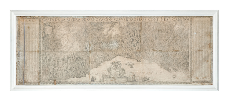
Joseph Chafrion's legendary map of Liguria, known from only one institutional copy, and confused throughout the literature with the common posthumous copy engraved and printed by Marcantonio dal Re around 1740
The title runs the entire length of the drawing, which is inscribed in a decorative frame. At the bottom center, a rich and lively cartouche contains the dedication to the Count of Melgar and the graphic scales. At the bottom right, "Autor Sculpist" is inscribed. The topography is represented using the perspective system of mounds. The most important settlements are shown schematically in plan; the secondary ones with towers and houses. The roads are drawn and the political boundaries are indicated. Limits: north, Valenza; south, Ligurian Sea (from Nice to Motrone); west, Monviso; east, Mount Lugo. At the top left, the legend for the conventional symbols. Three graphic scales in miles for Genoa, Piedmont, and Italy.
An impressive, extremely detailed map of Liguria, this copy also includes rare lateral legends (not present in the only other known copy, held at the Moravian Library in Brno) listing all the places depicted on the map with their coordinates. Joseph Chafrion drew and engraved the map at the commission of the governor and captain general of the State of Milan, Don Giovanni Tommaso Enriquez de Cabrera, as Liguria represented a strategic link between Spain and the Duchy of Milan, a Spanish possession from 1535 to 1706. Chafrion's work represents a clear improvement over previous cartographic representations, becoming an essential cornerstone for the representation of the Ligurian territory in its entirety.
José Chafrion (born Josep Chafrion in 1653 in Valencia) was a renowned military engineer in the service of the King of Spain. He is known for directing the construction of Montjuïc Castle between 1694 and 1697 and the fortification of other squares in Catalonia. In 1671, at the age of 18, he went to Rome, where he studied under Bishop Juan Caramuel y Lobkowitz. In May 1673, Chafrion became assistant to the chief engineer of the army of the State of Milan. He was known as a distinguished physicist and mathematician and publicly defended his thesis at the Roman College of the Jesuit Order in Rome. He served King Charles II of Spain in the State of Milan from 1684 to approximately 1691, first as captain of the Tercio de la Mar in Naples and, from September 1686, as captain of the Tercio de Lombardia. He later served as captain of the cuirassiers.
The reason for the incredible rarity of Chafrion's original map, which does not appear to be such only due to the great confusion that was created with its copy by Marcantonio dal Re, is explained to us by Massimi Quaini in his essay for The History of Cartography: “Two other incidents illuminate the attitude of the Genoese authorities toward accurate maps of the Republic. These authorities actively tried to hinder the publication of the Carta de la Rivera de Genova con sus verdaderos confines y caminos (Milan, 1685) by José Chafrion, a Catalan military engineer at the service of the governor of Milan and considered withdrawing the engraved plates before printing to protect the state’s military and diplomatic status. The second episode concerned the French cartographer Ludovico della Spina, who in 1696 presented the Genoese authorities with a map of their state, and as “Geographer to the King” offered the Republic his services. Although they judged the map “very diligent, duly adjusted to the facts . . . and worthy of seeing the light of day”, the Genoese government nevertheless asked the author not to print it. The Republic’s wariness of printed maps stemmed from the fear that the publication of a new official map might spark diplomatic conflict by resurrecting border disputes, particularly with the Republic’s more aggressive neighbor, the Duchy of Savoy. The Republica adopted a sort of prudent neutrality, relying more on its system of natural and manmade defenses than on force of arms, while the Duchy of Savoy followed a much bolder and more aggressive foreign policy. […] As one can see from the episode of the Chafrion map, the Republic expressed concern not over simple maps but over maps that revealed “knowledge of mountain passes and of the weakness of [military] sites” works that met the needs of the military campaigner or the territorial administrator” (cfr. Cartographic Activities in the Republic of Genoa, Corsica, and Sardinia in the Renaissance, in “The History of Cartography, Volume 3: Cartography in the European Renaissance”, p. 863. Although the Chafrion map is discussed, the British Library example of Marcantonio dal Re's copy, mistaken for the original map, is also illustrated here).
The map was therefore subjected to government censorship, the same censorship that also affected the later map by Ludovico della Spina (Louis de Lépine). This censorship prevented its distribution. Chafrion's work represented a clear improvement over previous cartographic representations, becoming an essential cornerstone for the depiction of the Ligurian territory in its entirety. Indeed, it would be imitated and reprinted several times: by Domenico de Rossi in Rome in 1697, by Andrew Dury in London in 1764, by Faden's edition in London in 1783, and finally by Gravier's work in 1784, first in the Turin edition and then, later that year, in the Genoa edition. Among these derivations, we must now add Marcantonio dal Re's copy, which until now has been confused with the original Chafrion map. However, perhaps it would have been enough to look at the biographical information relating to Dal Re, born in Bologna in 1697, to exclude the impossibility of his involvement in the Chafrion map of 1685. Nor is the possibility that he was the editor of a posthumous edition of the original map convincing. Indeed, by carefully analyzing the two maps, it is evident that they were obtained from different plates. Toponyms, mountains, coastlines and so on are completely different upon careful comparative examination.
We can therefore conclude that Dal Re's map is a faithful and misleading copy of Chafrion's original; a plagiarism that maintains the original date (1685) and Chafrion's signature.
From an editorial perspective, Chafrion's map bears the inscription on the title block: Se venden en Milan en Casa de el Quinto à la Plaza de los Mercaderes; at the bottom right, Autor Sculpsit. In Marcantonio dal Re's copy, the editorial details on the cartouche disappear, replaced by an imprint at the bottom right: Si vendono in Milano da Marc. Ant. del Re Incisore in Rame alla Piazza de' Mercanti presso le scuole Palatine”. The dating of Dal Re's copy can be deduced from his biography; having moved from Bologna to Milan in 1726, he sold under the “insegna dell'Aquila imperiale in contrada S. Margherita”. In 1739, he moved to "Piazza Mercanti al Portico superiore delle Scuole Palatine" in the Loggia degli Osii, which he had rented at his request to the Vicar of Provision in order to have bright rooms suitable for his business. Therefore, from the imprint on his map of Liguria, it can be deduced that it is certainly after 1739.
Etchings, printed on 8 sheets and lais down on canvas, within a frame, protected by glass.
Considered by many authoritative scholars to be the most important map of Liguria. I don't know of any other copies that have the caption. The only institutional copy of this map that we have been able to catalogue is the one held at the Moravian Library in Brno, Czech Republic.
For a comparison between our original Chafrion map and the copy vy Marcantonio dal Re, please refer to this digitized copy from the Bibliothèque Nationale de France.
https://gallica.bnf.fr/ark:/12148/btv1b53011968b/f1.item.zoom
Bibliografia
Pietro Barozzi, La Carta de la Rivera de Genova di Joseph Chafrion (1685), in “La Sardegna nel mondo mediterraneo”; G. Ferro, La Liguria nelle Carte e nelle Vedute Antiche (1992); M. Quaini, Per la Storia della Cartografia a Genova e in Liguria. Formazione e ruolo degli ingegneri-geografi nella vita della Repubblica (1656-1717), pp. 230-231, fig. 5; M. Quaini, Cartographic Activities in the Republic of Genoa, Corsica, and Sardinia in the Renaissance, in “The History of Cartography, Volume 3: Cartography in the European Renaissance”, pp. 863-864.
|
José Chafrion (born Josep Chafrion in 1653 in Valencia-Barcelona, 1698) was a famous military engineer in the service of the King of Spain. He is known for directing the construction of Montjuic Castle between 1694 and 1697 and the fortification of other squares in Catalonia. His main work is the book Escuela de Palas, or Curso mathematico of 1693; a fundamental work for military engineers of the time. He began his early studies in his hometown, where he had José Zaragoza as his teacher. In 1671, at the age of 18, he went to Rome where he was a disciple of Bishop Juan Caramuel y Lobkowitz. In May 1673, Chafrion became assistant to the senior engineer of the army of the State of Milan. He was known as a distinguished physicist-mathematician and publicly defended his final thesis at the Roman College of the Jesuit Order in the city of Rome. In 1682 he assisted Caramuel in his final days and Caramuel left him his copious library. He served King Charles II of Spain in the State of Milan from about 1684 to 1691, first as captain of the Tercio de la Mar in Naples and, from September 1686, as captain of the Tercio de Lombardia. Later, he was captain of the cuirassiers. In January 1688 he was commissioned by the jurors of the city of Valencia to draw up a plan of the port of El Grao. In September 1688 the Nine Years' War broke out between France and the Duchy of Savoy. In 1690, José Chafrion was wounded in the Battle of Stafarda; he was also present at the demolition of the fortress of Guastalla, capital of the Duchy of Guastalla, and at the siege of Casale Monferrato. In 1691 he was appointed aide-de-camp or assistant to the governor of the State of Milan, Diego Dávila Mesía y Guzmán, III Marquis of Leganés, who held the post from 1691 to 1698. Around 1693 he was appointed major engineer in Catalonia with the rank of field master of infantry and quartermaster general. The war continued and Chafrion participated in the Battle of Ter on May 26, 1694, also known as the Battle of Torroella, and in all the other military actions in Catalonia against the French army. In 1696 the Treaty of Turin (1696) was signed. His is the technical report to Carlos Adrián de Sucre and Ives (Sucre Family), Marquis of Preux, dated August 6, 1697, recommending the surrender of the city of Barcelona to French troops during the Siege of Barcelona. The final decision was made by Diego Hurtado de Mendoza y Sandoval, count of La Corzana and viceroy of Catalonia. The war ended in September 1697 with the Treaty of Rijswijk. He died in Barcelona on July 10, 1698, at the age of 45, and was buried in the chapel of the Virgen de los Dolores in the convent of Nuestra Senora del Buen Suceso of the Order of Servants. His coffin was carried on the shoulders of four generals.
His major works are:
1685 Carta de la Rivera de Génova con sus verdaderos confines y caminos
1685 Topografía de Liguria dedicado al Excelentísimo Señor Conde de Melgar, Gobernador y Capitán General del Estado de Milán
1687 La Sabbioneta
1687 Planta de las Fortificaciones de las Ciudades, Plazas y Castillos del Estado de Milán
1693 Escuela de Palas, o sea Curso mathemático
1695 Diseño del Baluarte de Tierra delante del Portal de Tallers en Barcelona
Planta del Cuartel de Ostalric
|
|
José Chafrion (born Josep Chafrion in 1653 in Valencia-Barcelona, 1698) was a famous military engineer in the service of the King of Spain. He is known for directing the construction of Montjuic Castle between 1694 and 1697 and the fortification of other squares in Catalonia. His main work is the book Escuela de Palas, or Curso mathematico of 1693; a fundamental work for military engineers of the time. He began his early studies in his hometown, where he had José Zaragoza as his teacher. In 1671, at the age of 18, he went to Rome where he was a disciple of Bishop Juan Caramuel y Lobkowitz. In May 1673, Chafrion became assistant to the senior engineer of the army of the State of Milan. He was known as a distinguished physicist-mathematician and publicly defended his final thesis at the Roman College of the Jesuit Order in the city of Rome. In 1682 he assisted Caramuel in his final days and Caramuel left him his copious library. He served King Charles II of Spain in the State of Milan from about 1684 to 1691, first as captain of the Tercio de la Mar in Naples and, from September 1686, as captain of the Tercio de Lombardia. Later, he was captain of the cuirassiers. In January 1688 he was commissioned by the jurors of the city of Valencia to draw up a plan of the port of El Grao. In September 1688 the Nine Years' War broke out between France and the Duchy of Savoy. In 1690, José Chafrion was wounded in the Battle of Stafarda; he was also present at the demolition of the fortress of Guastalla, capital of the Duchy of Guastalla, and at the siege of Casale Monferrato. In 1691 he was appointed aide-de-camp or assistant to the governor of the State of Milan, Diego Dávila Mesía y Guzmán, III Marquis of Leganés, who held the post from 1691 to 1698. Around 1693 he was appointed major engineer in Catalonia with the rank of field master of infantry and quartermaster general. The war continued and Chafrion participated in the Battle of Ter on May 26, 1694, also known as the Battle of Torroella, and in all the other military actions in Catalonia against the French army. In 1696 the Treaty of Turin (1696) was signed. His is the technical report to Carlos Adrián de Sucre and Ives (Sucre Family), Marquis of Preux, dated August 6, 1697, recommending the surrender of the city of Barcelona to French troops during the Siege of Barcelona. The final decision was made by Diego Hurtado de Mendoza y Sandoval, count of La Corzana and viceroy of Catalonia. The war ended in September 1697 with the Treaty of Rijswijk. He died in Barcelona on July 10, 1698, at the age of 45, and was buried in the chapel of the Virgen de los Dolores in the convent of Nuestra Senora del Buen Suceso of the Order of Servants. His coffin was carried on the shoulders of four generals.
His major works are:
1685 Carta de la Rivera de Génova con sus verdaderos confines y caminos
1685 Topografía de Liguria dedicado al Excelentísimo Señor Conde de Melgar, Gobernador y Capitán General del Estado de Milán
1687 La Sabbioneta
1687 Planta de las Fortificaciones de las Ciudades, Plazas y Castillos del Estado de Milán
1693 Escuela de Palas, o sea Curso mathemático
1695 Diseño del Baluarte de Tierra delante del Portal de Tallers en Barcelona
Planta del Cuartel de Ostalric
|