| Reference: | 4841 |
| Author | Willem Janszoon BLAEU |
| Year: | 1606 |
| Zone: | Italy |
| Printed: | Amsterdam |
| Measures: | 560 x 410 mm |
| Reference: | 4841 |
| Author | Willem Janszoon BLAEU |
| Year: | 1606 |
| Zone: | Italy |
| Printed: | Amsterdam |
| Measures: | 560 x 410 mm |
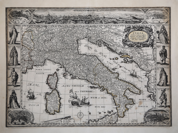
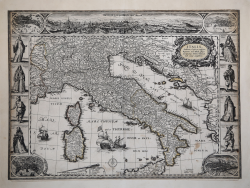
- FIRTS EDITION OF THE FIRST CARTE A FIGURE OF ITALY -
Etching and engraving, 1606, signed and dated in the plate lower right. Example of the very rare first state of four, with the imprint Guilelmus Iannsonius, published in 1606. Magnificent proof, rich in shades, printed on contemporary laid paper, trimmed to the marginal line and with added margins, overall in very good condition. Contemporary delicate coloring.
The first examples of the so-called "carte à figures", born in Holland in the late '500. One of the first representations of a decorated map is the famous Travel of Abraham by Ortelius, published in the Parergon of 1586. For this map Ortelius had the collaboration of the painter Maarten de Vos, who designed the sets for the decorated border. Jodocus Hondius in 1590, produces 3 small maps of England, France and the Netherlands with decorated edges, followed by Pieter van den Keere (Kaerius), which in 1596 created a map of Holland decorated. But the real development to the maps with the decor gave it a wall map of Europe in 15 sheets of Jodocus Hondius (1595) and the map of the World in 20 sheets of Willem J. Blaeu in 1605. In the following years, Blaeu created several maps decorated, in-folio format, starting from the map of Italy in 1606.
From the cartographic point of view, the map is entirely based on the work by Mercator of 1589, which was then inserted also in & Mercator Hondius atlas published in 1606 in Amsterdam by Jodocus Hondius. The map presents decorated on three edges. The upper side is made up almost entirely of a long panorama of Rome, which are combined with a plan of Venice and one of Genoa. In the lower corners, are the plants of Naples and Florence, while the sides costume depicting scenes noblemen and noblewomen of the main sites of the peninsula. The source of the panorama of Rome is definitely the great view of the city designed by Hedrick van Cliven and published in Amsterdam by Hendrick Hondius (1599-1605). Other city maps are clearly reductions of the plates inserted in the Civitates Orbis Terrarum by Braun & Hogenberg.
The map had a second state, by Blaeu, around 1620, and two reprints edited by Cornelis and Danker Dankerts (1640 and 1661). All editions of this paper are absolutely rare. Schilder lists only 10 known examples of this map, no one present in the Italian collections. Borri cites the first state of the map, which assigns to the rarity of 95/100, describing it as "fine and decorative map in strict style mercatoriano, rare, never reprinted, is the first of its kind of cartes à figures", thus ignoring the ' existence of successive states.
|
G. Schilder, Monumenta Cartographica Neerlandica, vol. VI, pp. 55/63 e 367/370, 89; Borri, L’Italia nelle antiche carte dal medioevo all’unità nazionale, p. 97, 89.
|
Willem Janszoon BLAEU (Uitgeest 1571- Amsterdam 1638)
|
At the beginning of the seventeenth century Amsterdam was becoming one of the wealthiest trading cities in Europe, the base of the Dutch East India Company and a centre of banking and diamond trades, its people noted for their intellectual skills and splendid craftsmanship.
At this propitious time in the history of the Northern Provinces, Willem Janszoon Blaeu, who was born at Alkmaar in 1571 and trained in astronomy and the sciences by Tycho Brahe, the celebrated Danish astronomer, founded a business in Amsterdam in 1599 as a globe and instrument maker.
It was not long before the business expanded, publishing maps, topographical works and books of sea charts as well as constructing globes.
His most notable early work was a map of Holland (1604), a fine World Map (1605-06) and Het Licht der Zeevaerdt (The Light of Navigation), a marine atlas, which went through many editions in different languages and under a variety of titles.
At the same time Blaeu was planning a major atlas intended to include the most up-to-date maps of the whole known world but progress on so vast a project was slow and not until he bought between 30 and 40 plates of the Mercator Atlas from Jodocus Hondius II to add to his own collection was he able to publish, in 1630, a 60-map volume with the title Atlantis Appendix.
It was another five years before the first two volumes of his planned world atlas, Atlas Novus or the Theatrum Orbis Terrarum were issued. About this time he was appointed Hydrographer to the East India Company.
In 1638 Willem Blaeu died and the business passed into the hands of his sons, Joan and Cornelis, who continued and expanded their father's ambitious plans.
After the death of Cornelis, Joan directed the work alone and the whole series of 6 volumes was eventually completed about 1655.
As soon as it was finished he began the preparation of the even larger work, the Atlas Major, which reached publication in 1662 in II volumes (later editions in 9-12 volumes) and contained nearly 6oo double-page maps and 3,000 pages of text.
This was, and indeed remains, the most magnificent work of its kind ever produced; perhaps its geographical content was not as up-to-date or as accurate as its author could have wished, but any deficiencies in that direction were more than compensated for by the fine engraving and colouring, the elaborate cartouches and pictorial and heraldic detail and especially the splendid calligraphy.
In 1672 a disastrous fire destroyed Blaeu's printing house in the Gravenstraat and a year afterwards Joan Blaeu died. The firm's surviving stocks of plates and maps were gradually dispersed, some of the plates being bought by F. de Wit and Schenk and Valck, before final closure in about 1695.
It ought to be mentioned here that there is often confusion between the elder Blaeu and his rival Jan Jansson (Johannes Janssonius). Up to about 1619 Blaeu often signed his works Guilielmus Janssonius or Willems Jans Zoon but after that time he seems to have decided on Guilielmus or G. Blaeu.
|
|
G. Schilder, Monumenta Cartographica Neerlandica, vol. VI, pp. 55/63 e 367/370, 89; Borri, L’Italia nelle antiche carte dal medioevo all’unità nazionale, p. 97, 89.
|
Willem Janszoon BLAEU (Uitgeest 1571- Amsterdam 1638)
|
At the beginning of the seventeenth century Amsterdam was becoming one of the wealthiest trading cities in Europe, the base of the Dutch East India Company and a centre of banking and diamond trades, its people noted for their intellectual skills and splendid craftsmanship.
At this propitious time in the history of the Northern Provinces, Willem Janszoon Blaeu, who was born at Alkmaar in 1571 and trained in astronomy and the sciences by Tycho Brahe, the celebrated Danish astronomer, founded a business in Amsterdam in 1599 as a globe and instrument maker.
It was not long before the business expanded, publishing maps, topographical works and books of sea charts as well as constructing globes.
His most notable early work was a map of Holland (1604), a fine World Map (1605-06) and Het Licht der Zeevaerdt (The Light of Navigation), a marine atlas, which went through many editions in different languages and under a variety of titles.
At the same time Blaeu was planning a major atlas intended to include the most up-to-date maps of the whole known world but progress on so vast a project was slow and not until he bought between 30 and 40 plates of the Mercator Atlas from Jodocus Hondius II to add to his own collection was he able to publish, in 1630, a 60-map volume with the title Atlantis Appendix.
It was another five years before the first two volumes of his planned world atlas, Atlas Novus or the Theatrum Orbis Terrarum were issued. About this time he was appointed Hydrographer to the East India Company.
In 1638 Willem Blaeu died and the business passed into the hands of his sons, Joan and Cornelis, who continued and expanded their father's ambitious plans.
After the death of Cornelis, Joan directed the work alone and the whole series of 6 volumes was eventually completed about 1655.
As soon as it was finished he began the preparation of the even larger work, the Atlas Major, which reached publication in 1662 in II volumes (later editions in 9-12 volumes) and contained nearly 6oo double-page maps and 3,000 pages of text.
This was, and indeed remains, the most magnificent work of its kind ever produced; perhaps its geographical content was not as up-to-date or as accurate as its author could have wished, but any deficiencies in that direction were more than compensated for by the fine engraving and colouring, the elaborate cartouches and pictorial and heraldic detail and especially the splendid calligraphy.
In 1672 a disastrous fire destroyed Blaeu's printing house in the Gravenstraat and a year afterwards Joan Blaeu died. The firm's surviving stocks of plates and maps were gradually dispersed, some of the plates being bought by F. de Wit and Schenk and Valck, before final closure in about 1695.
It ought to be mentioned here that there is often confusion between the elder Blaeu and his rival Jan Jansson (Johannes Janssonius). Up to about 1619 Blaeu often signed his works Guilielmus Janssonius or Willems Jans Zoon but after that time he seems to have decided on Guilielmus or G. Blaeu.
|