| Reference: | S46140 |
| Author | Abraham ORTELIUS |
| Year: | 1594 ca. |
| Zone: | France |
| Printed: | Antwerpen |
| Measures: | 495 x 395 mm |
| Reference: | S46140 |
| Author | Abraham ORTELIUS |
| Year: | 1594 ca. |
| Zone: | France |
| Printed: | Antwerpen |
| Measures: | 495 x 395 mm |
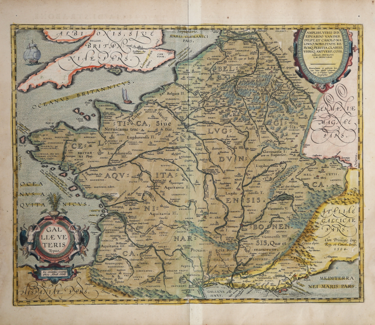
Splendid historical map of France (Gallia), published in Abraham Ortelius' Parergon.
Example from the rare Italian edition of Theatrum Orbis Terrarum printed in Antwerp by Jean Baptiste Vrients in 1608 and then in 1612.
A second state of the plate; from 1601 onwards, just North of the Pyrenees "MAVRI" was added twice; Northwest of the Jura mountain range, "SEQ:VA:NI." was added. "Marsi:lia" [Marseille] was changed to: "Massilia".
Title: GAL:|LIÆ VE:|TERIS/Typus. | "Ex conatibus Geogra:|phicis Abrah. Ortelij". [Map of ancient France, from the geographical efforts of Abraham Ortelius]. Lower right the privilege: "Cum Priuilegio Imp. | Reg. et Cancel. Brab. | 1594".
Cartouche top right the dedication to Edward van der Delft and Karol (van) Mechelen: AMPLISS. VIRIS DD. | EDVARDO VAN DER | DILFT, ET CAROLO MA:|LINEO, NOBILITATE RE:|RVMQ. PERITIA CLARISS. | VRBISQ. ANTVERP. COSS. | ABRAH. ORTELIVS | L.M. DEDICABAT. | "Nomenclaturæ et positionis loco:|rum huius tabulæ testimonia, | pete ex Thesauro nostro | Geographico". [Abraham Ortelius of Antwerp has willingly dedicated this [map] to the most honoured men lord Edward van der Delft and Carolus from Mechelen, very famous in nobility and most renowned in matters of experience. For names and locations of places on this map, use our geographical Treasury].
This map was made by Ortelius on the basis of Strabo, Plinius, Vergilius, Ovidius, Cæsar and other classical sources.
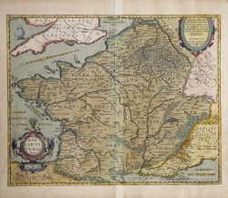
The Parergon also contains another map of the same territorial area, with the title Gallia Vetus (Van den Broecke, Ort194). The major difference is the Galliae Veteris Typus described here is based on ancient geographical sources rather than ancient military sources and is much more detailed. It contains the largest amount of text to be found on any of Ortelius' maps (about 16,000 words), testyfing the importance Ortelius attached to it. The discussion he devotes to this map is the civil counterpart of Ort 194, which both in appearance and accompanying text is devoted more exclusively to a military picture of France and its Druids. It has a heavy emphasis on Roman times, particularly as reported by the ancient geographer Strabo.
The Parergon is the first historical atlas ever published. It was initially conceived by Ortelius as an appendix to his Theatrum Orbis Terrarum but given the considerable success of these historical maps it later became an independent work and remained the main source of all similar works throughout the seventeenth century.
Koeman wrote: “This atlas of ancient geography must be regarded as a personal work of Ortelius. For this work he did not, as in the Theatrum, copy other people's maps but drew the originals himself... He took many places and regions from the lands of classical civilization to illustrate and clarify their history, a subject very close to his heart... The maps and plates of the Parergon have to be evaluated as the most outstanding engravings depicting the wide-spread interest in classical geography in the 16th century."
The Theatrum Orbis Terrarum, which is considered the first true modern "Atlas". The work was published in 7 languages and 36 editions, for which - in 1570 - Ortelius obtained the privilege, a kind of copyright that prevented other cartographers from publishing his works. The Theatrum represented the most advanced work of cartographic description. Ortelius collected in it the geographical and cartographic knowledge of his time, proposing in 147 spectacular engraved plates the most faithful image of the world then known and, in some extraordinary "historical maps", regions and routes taken from literature, mythology, tradition.
Example with magnificent contemporary coloring, paper slightly browned, otherwise in excellent condition.
Bibliografia
Cfr. L. Bagrow, A. Ortelli Catalogus Cartographorum; cfr. C. Koeman, Atlantes Neerlandici; Peter H. Meurer, Fontes Cartographici Orteliani, n. 27p; M. Van den Broecke, Ortelius Atlas Maps, n. 196 II/II; Van der Krogt, Koeman’s Atantes Neerlandici: 4000H:31C.
Abraham ORTELIUS (1528 - 1598)
|
Abraham Ortel, better known as Ortelius, was born in Antwerp and after studying Greek, Latin and mathematics set up his business there with his sister, as a book dealer and 'painter of maps'. Travelling widely, especially to the great book fairs, his business prospered and he established contacts with many sultured men in many lands. On one such visit to England, possibly seeking temporary refuge from religious persecution, he met William Camden whom he is said to have encouraged in the production of the Britannia.
A turning-point in his career was reached in 1564 with the publication of a World Map in eight sheets of which only one copy is known: other individual maps followed and then - at the suggestion of a friend - he gathered together a collection of maps from contacts among European cartographers and had them engraved in uniform size and issued in 1570 as the Theatrum Orbis Terrarum (Atlas of the Whole World). Although Lafreri and others in Italy had published collections of 'modern' maps in book form in earlier years, the Theatrum was the first uniformly sized, systematic collection of maps and hence can be called the first atlas, although that term itself was not used until twenty years later by Mercator.
The Theatrum, with most of its maps elegantly engraved by Frans Hogenberg, was an instant success and appeared in numerous editions in different languages including addenda issued from time to time incorporating the latest contemporary knowledge and discoveries. The final edition appeared in 1612. Unlike many of his contemporaries Ortelius noted his sources of information and in the first edition acknowledgement was made to eighty-seven different cartographers.
Apart from the modern maps in his major atlas, Ortelius himself compiled a series of historical maps known as the Parergon Theatri which appeared from 1579 onwards, sometimes as a separate publication and sometimes incorporated in the Theatrum.
1570 Theatrum Orbis Terrarum 1570-1612 Between these years the Theatrum was re-issued in 42 editions with 5 supplements with text in Latin, Dutch, German, French, Spanish, Italian and English. The English edition was published in 1606 by John Norton, the maps being printed in Antwerp and the text added in London. Three years later Ortelius died in 1598, his heirs transferred publication rights to Jan Baptiste Vrients who produced the posthumous editions until he died in 1612
1577-85 Spiegel der Werelt (8vo) Maps from the Theatrum, reduced in size, engraved by Philip Galle: text by Pieter Heyns. 6 editions with Dutch, French and Latin text. 1588-i 603 Epitome theatri orbis terrarum (12mo/8v0) 11 further editions of the smaller maps with an increasing number of maps with text also in Italian and English (1603). i6oi-i 2 7 further editions with improved engravings by Arsenius Brothers: text by Michel Coignet in Latin, French, German, Italian and English (1603). 1598-1724 Theatro del Mondo (4t0/12mo/24mo) 8 editions with Italian text; plates engraved in Italy.
1579-1606 Parergon Theatri The number of maps included in the Parergon increased from 4 in 1579 to 43 in 1606 with text in Latin, French, Italian, German and English (1606) 1624 Re-issued in Antwerp as a separate publication by Balthasar Moretus. This edition included a reproduction of the Peutinger table.
|