
| Reference: | S46135 |
| Author | Abraham ORTELIUS |
| Year: | 1572 ca. |
| Zone: | Croatia & Slovenia |
| Printed: | Antwerpen |
| Measures: | 430 x 530 mm |
| Reference: | S46135 |
| Author | Abraham ORTELIUS |
| Year: | 1572 ca. |
| Zone: | Croatia & Slovenia |
| Printed: | Antwerpen |
| Measures: | 430 x 530 mm |
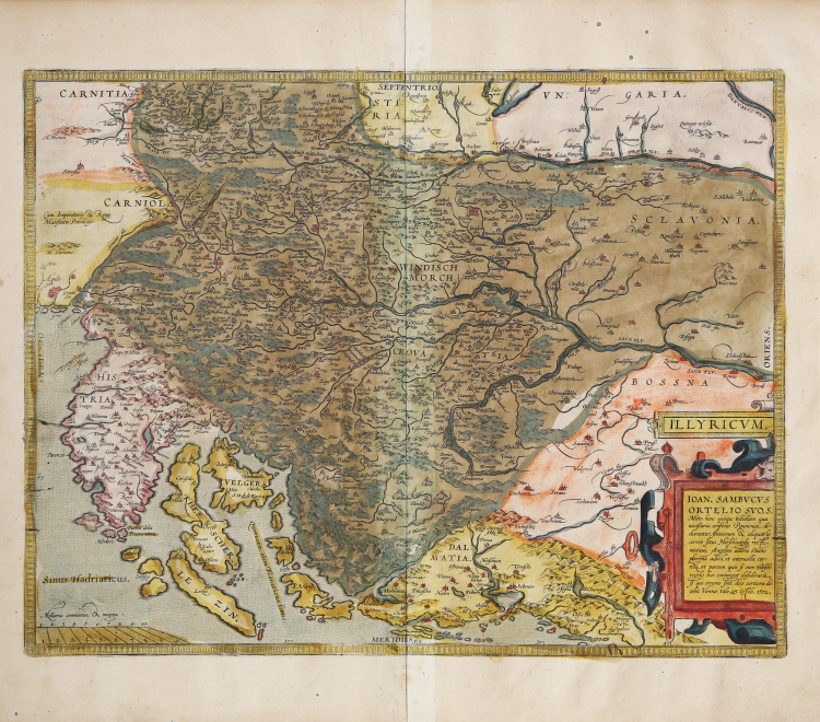
Finely colored map of of Istria, Slovenia and Croatia by Abraham Ortelius. As noted in the lower right cartouche, this map was by Johann Sambucus in 1572.
Map of the region from Triest and Villach in the west to Brod in the east, along the course of the Sava, centered on Zagreb and Novograd.
Includes nice detail along the Dalmatian Coast, including Zara, Alt Zara and Spalato, among othe coastal towns.
ILLYRICUM. IOAN. SAMBVCVS | ORTELIO SVO S. | "Mitto hanc quoque tabellam qua | neceßaria confinia Pannoniæ de:|clarantur, fluuiorum & aliquot lo:|corum situs, Hirschvogelij recte | mutaui, Angelini autem studio | plurima adieci, et interualla cor:|rexi, vt parum quis si cum Hirsch:|vogelij hæc coniungat desiderarit, | si qui errores sint, dies certiora do:|cebit, Viennæ, Vale, 25 October 1572". Upper left: "Cum Imperatoriæ et Regiæ | Maiestatis Priuilegio".
The Cartographic sources is the map by Johann Sambucus 1572, based on Hirschvogel 1565 (Karrow 40/9.1 p. 299-300, 461, Meurer p. 227). As indicated in the title, Ioannes Sambucus greets his friend Ortelius. I also send a modest representation in which the necessary boundaries of Pannonia are being described, as well as the location of rivers and some places. Those provided by Hirschvogel I have changed and to those of Angelinus I have added some, and I have corrected some distances so that, when they are compared to those of Hirschvogel, which contain some mistakes, he can get to know the truth with greater certainty. Vienna, farewell, October 25, 1572.
From the rare Italian edition of Abraham Ortelius' Theatrum Orbis Terrarum, 1608, published by Vrients.
The Theatrum Orbis Terrarum is considered the first true modern "Atlas". The work was published in 7 languages and 36 editions, for which - in 1570 - Ortelius obtained the privilege, a kind of copyright that prevented other cartographers from publishing his works. The Theatrum represented the most advanced work of cartographic description. Ortelius collected in it the geographical and cartographic knowledge of his time, proposing in 147 spectacular engraved plates the most faithful image of the world then known and, in some extraordinary "historical maps", regions and routes taken from literature, mythology, tradition. Ortelius was also the first to cite sources, mentioning the names of cartographers in the "catalogus auctorum". From 1598 to 1612 the posthumous editions of the Theatrum were made by his collaborator Johannes Baptiste Vrients.
Copperplate with fine original hand colouring, in good condition.
Bibliografia
Van den Broecke, Ortelius 144; Gròf (1979) "The Map Collector" 6 p. 2-11, (1992) Cartographica Hungarica 1: pp. 26-36.
Abraham ORTELIUS (1528 - 1598)
|
Abraham Ortel, better known as Ortelius, was born in Antwerp and after studying Greek, Latin and mathematics set up his business there with his sister, as a book dealer and 'painter of maps'. Travelling widely, especially to the great book fairs, his business prospered and he established contacts with many sultured men in many lands. On one such visit to England, possibly seeking temporary refuge from religious persecution, he met William Camden whom he is said to have encouraged in the production of the Britannia.
A turning-point in his career was reached in 1564 with the publication of a World Map in eight sheets of which only one copy is known: other individual maps followed and then - at the suggestion of a friend - he gathered together a collection of maps from contacts among European cartographers and had them engraved in uniform size and issued in 1570 as the Theatrum Orbis Terrarum (Atlas of the Whole World). Although Lafreri and others in Italy had published collections of 'modern' maps in book form in earlier years, the Theatrum was the first uniformly sized, systematic collection of maps and hence can be called the first atlas, although that term itself was not used until twenty years later by Mercator.
The Theatrum, with most of its maps elegantly engraved by Frans Hogenberg, was an instant success and appeared in numerous editions in different languages including addenda issued from time to time incorporating the latest contemporary knowledge and discoveries. The final edition appeared in 1612. Unlike many of his contemporaries Ortelius noted his sources of information and in the first edition acknowledgement was made to eighty-seven different cartographers.
Apart from the modern maps in his major atlas, Ortelius himself compiled a series of historical maps known as the Parergon Theatri which appeared from 1579 onwards, sometimes as a separate publication and sometimes incorporated in the Theatrum.
1570 Theatrum Orbis Terrarum 1570-1612 Between these years the Theatrum was re-issued in 42 editions with 5 supplements with text in Latin, Dutch, German, French, Spanish, Italian and English. The English edition was published in 1606 by John Norton, the maps being printed in Antwerp and the text added in London. Three years later Ortelius died in 1598, his heirs transferred publication rights to Jan Baptiste Vrients who produced the posthumous editions until he died in 1612
1577-85 Spiegel der Werelt (8vo) Maps from the Theatrum, reduced in size, engraved by Philip Galle: text by Pieter Heyns. 6 editions with Dutch, French and Latin text. 1588-i 603 Epitome theatri orbis terrarum (12mo/8v0) 11 further editions of the smaller maps with an increasing number of maps with text also in Italian and English (1603). i6oi-i 2 7 further editions with improved engravings by Arsenius Brothers: text by Michel Coignet in Latin, French, German, Italian and English (1603). 1598-1724 Theatro del Mondo (4t0/12mo/24mo) 8 editions with Italian text; plates engraved in Italy.
1579-1606 Parergon Theatri The number of maps included in the Parergon increased from 4 in 1579 to 43 in 1606 with text in Latin, French, Italian, German and English (1606) 1624 Re-issued in Antwerp as a separate publication by Balthasar Moretus. This edition included a reproduction of the Peutinger table.
|