| Reference: | MS3436 |
| Author | Goert van SCHAYCK |
| Year: | 1627 ca. |
| Zone: | Europe |
| Printed: | Rome |
| Measures: | 1110 x 830 mm |
| Reference: | MS3436 |
| Author | Goert van SCHAYCK |
| Year: | 1627 ca. |
| Zone: | Europe |
| Printed: | Rome |
| Measures: | 1110 x 830 mm |
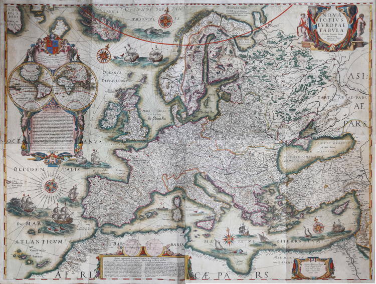
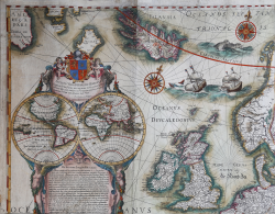
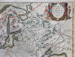
NOVA | TOTIVS | EVROPAE | TABVLA | AVCTORE IOANNES BLAEV | AMSTELADAMI | Jo. Jacobus de Rubeis Formis Romæ. [Roma]: Joannes Jacobus de Rubeis | Formis Romæ ad Tem= | plum Pacis cum Priui | legio Summi Pont. | Anno 1686.
Title in a cartouche in upper right corner, the imprint in the lower right corner. The tripartite cartouche with the legend concerning degrees of longitude bears the following dedication: INCLYTO VIRO D. HORATIO QVARANTE | Quatuor Orbis Partes tuis non minus studijs, quam possibus | hactenus Virtuti non obuiam tuæ. Vale | Jo. Jacobus de Rubeis .
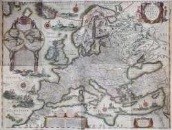
Very rare wall map of Europe (printed on 4 large sheets) first published circa 1627 by Goert van Schayck, with imprint Gottifridum de Scaickis... ad Signia Aquilae Imperialis. In the upper left corner, in a beautifully decorated cartouche containing the dedication to Orazio Quaranta, is engraved the map of the world with the classical representation in two hemispheres.
Example in the fifth final state, printed by Giovanni Giacomo de Rossi in 1686. Only 2 other examples of this map are known (see G. Schilder Monumenta Cartographica Neerlandica).
The map is based on Willelm Janszoon Blaeu's wall map, printed in Amsterdam in 1608 and belongs to the set of 4 wall maps of the continents.
Schilder describes two states from this map of Europe by De Rossi; he also describes two states from Goert van Schayck's map. However, he mistakenly does not believe that De Rossi's maps are printed with the plates first published by van Schayck.
“The De Rossi's publication of these wall maps met the increasing demand from the citizens of Rome who wanted to decorate the walls of their country houses with maps and town views. Giovanni Domenico already had a large map of the world hanging in his shop, mounted on linen and rollers, in order to tempt his clients to buy geographical material. De Rossi's acquisition and production of maps and town views was undoubtedly much stimulated by the commission of Pope Alexander VII who, in 1665, requested Giovanni Giacomo de Rossi to decorate a gallery in the papal summer residence of Castello Gandolfo with printed maps and plans. Supplying the maps to the Castello Gandolfo was an enormous task, as the walls were hung with no fewer than 176 printed maps of Europe, America and Rome. The material, which came from several map and print publishers, was coloured by hand and mounted on linen. Included in the list of purchased maps were those 'printed by Blaeu in Amsterdam'. The then most up-to-date list was Joan Blaeu's Catalogus librorvm et tabvlarvm (Amsterdam, 1661), in which the wall maps in several sheets (Tabulæ Geographicæ majori forma) were also offered for sale. We may assume that De Rossi purchased items from this catalogue. Apart from material by various Italian and foreign publishers, Giovanni Giacomo de Rossi also sold his own car- tographical products. As was mentioned above, the imitations of Willem Jansz Blaeu's wall maps of the four continents had also ap- peared around this time. Despite the fact that in the title Joan Blaeu was mentioned as author, these maps were in fact made by his father. Two states of De Rossi's wall maps of the four continents are known: the oldest one dates from 1666, the later one from 1686. The 1666 state became known only recently when Dr. Maria Teresa di Palma located a set in the collection of the Orvieto Cathedral. This set includes wall maps mounted on linen: the map is framed at the sides by costumed figures, and along the lower edge by twelve town views and plans. Outside this runs a text in Latin, embellished with illustrations. The entire map is framed on four sides by decorative strips” (cfr. G. Schilder Monumenta Cartographica Neerlandica, vol. V, pp. 203-205).
Below we have reconstructed the probable sequence of the states, so far unclear and never described in any publication, with the list of the known examples of the maps.
All known examples of these maps are in very poor to medium condition, extensively restored. In all, considering each edition, only 5 complete sets.
Editions and known examples:
1 state with the imprint of Gottifridum de Scaickis... ad Signia Aquilae Imperialis. Imprint in 3 maps of four (not in the America). According to Burden dated 1627 (The Mapping of North America, vol. II, p. xxiii, n. 219a) “the America follows the third state of Blaeu’s wall map”; Betz, The Mapping of Africa, pp. 233-234, Barry Mac Lane collection).
2 state with the imprint of Gottifridum de Scaickis...
Schilder (Monumenta Cartographica Neerlandica, vol. V, p. 208) talking about the set with the address of the imprint Gottifridum de Scaickis... ad Signia Aquilae Imperialis, said "on all the four maps (but only the 3, because America don’t have the imprint) the street name in the imprint has deliverately been scratched out". Probably the fact that the address of the imprint has been erased indicates that they were published after Van Schayck move from his original address and before the plates were purchased by Gian Giacomo De Rossi (1648).
Two sets of the maps are known: private French collection (Schilder MCN vol. V, p. 208), private German (Burden, The Mapping of North America, vol. II, p. xxiii, n. 219a).
3 state published by Gian Giacomo De Rossi in 1654. With decorative borders added (probably by De Rossi).
The date is on the letterpress of the borders on America and Africa maps (cfr. Schilder, MCN, vol. V, pp. 203-207). As Burden said “Presumed on the basis of the surviving set of 1666 bearing dates of 1654 in the letterpress” (The Mapping of North America, vol. II, p. xxiii, n. 219a).
No copy known.
4 state published by Gian Giacomo De Rossi in 1666.
With borders and with a letterpress of 1654. “All but the America bear the date 1666 in the imprint” (Burden, The Mapping of North America, vol. II, p. xxiii, n. 219a).
Only one set of the maps known, in the Museo Opera del Duomo of Orvieto (cfr. Maria Teresa di Palma, Le quattro carte murali dei continenti della Società Geografica Italiana, 1991, pp. 525-30; Schilder, MCN, vol. V, pp. 203-207).
5 state published by Gian Giacomo de Rossi in 1686. The maps, all but not America, bears the date 1686.
One set known at the Maritiem Museum, Rotterdam. An example of the map of Europe, with the date 1686, is in the University of Leyden (cfr. Schilder, MCN, vol. V, p. 207 3b).
Godefridus de Scaicki (as Schilder, Burden and Betz call him), is better known as Goert van Schayck and with the Italian name of Goffredo degli Scacchi. He was Greuter's son-in-law, having married his daughter Susanna in 1615. As documented by Greuter's 1618 Map of Rome, he worked and printed with a workshop ... ad Signia Aquilae Imperialis the same imprint present in these Schayck continents.
Etching and engraving, impressed on 4 sheets of contemporary laid virgin paper, trimmed to copperplate or thin margins, restoration at upper right perfectly executed, small stain in center, otherwise in good condition. A very rare work with fine later hand colour.
Bibliografia
G. Schilder Monumenta Cartographica Neerlandica, vol. V, pp. 202-208, 3&4; cfr. Maria Teresa di Palma, Le quattro carte murali dei continenti della Società Geografica Italiana, 1991, pp. 525-30; cfr. P. The Mapping of North America, vol. II, p. xxiii, n. 219a; cfr. R. Betz, The Mapping of Africa, pp. 233-234.
Goert van SCHAYCK (Attivo a Roma intorno alla metà del XVII sec.)
|
Publisher, printer, dealer born in Utrecht, but active in Rome, with shop in Parione, near the church of St. Thomas.
|
Goert van SCHAYCK (Attivo a Roma intorno alla metà del XVII sec.)
|
Publisher, printer, dealer born in Utrecht, but active in Rome, with shop in Parione, near the church of St. Thomas.
|