- New
| Reference: | A52904 |
| Author | Jodocus HONDIUS |
| Year: | 1606 ca. |
| Zone: | East Indies |
| Printed: | Amsterdam |
| Measures: | 480 x 350 mm |
| Reference: | A52904 |
| Author | Jodocus HONDIUS |
| Year: | 1606 ca. |
| Zone: | East Indies |
| Printed: | Amsterdam |
| Measures: | 480 x 350 mm |
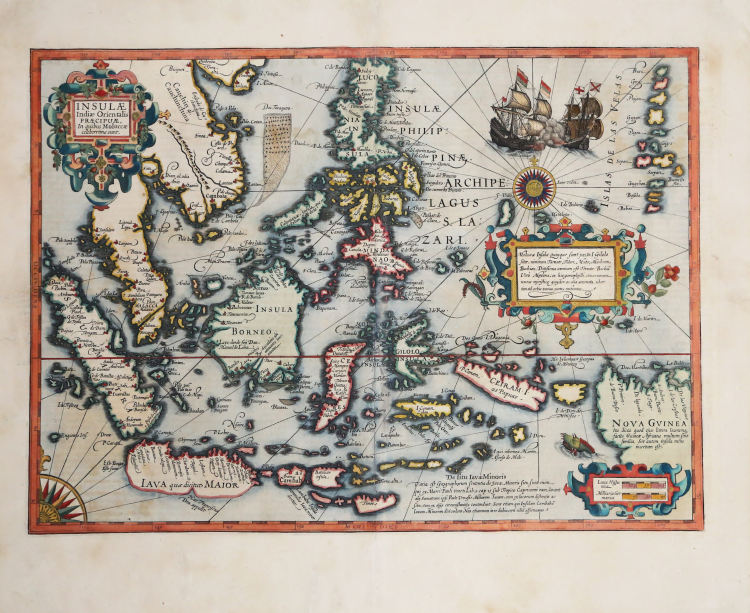
This extraordinary map of Southeast Asia and the East Indies was created by Jodocus Hondius in 1606 for his updated edition of Gerard Mercator’s atlas. The map visually represents the knowledge of East Asia accumulated by Western geographers from the dawn of the Age of Discovery through the first decade of the 17th century, drawing upon a variety of sources. The "Spice Islands" form the focal point of the map, reflecting Dutch interest in the lucrative spice trade of the Moluccas. Little was known about this region in the West; the map offers the most detailed depiction of the East Indies of its time and is one of the few regional maps to note Francis Drake’s passage through the area.
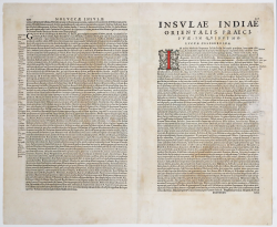
The map extends from China, Java, and Sumatra in the west to the Mariana Islands and New Guinea in the east. Details include cities, ports, and settlements, as well as river systems and mountain ranges; sandbanks and shoals are also marked. An exquisite title cartouche, decorated with ribbon motifs, occupies the upper right quadrant, obscuring part of the Chinese interior. A second cartouche in the lower right quadrant contains two graphic scales and covers part of the New Guinea coast, while a third lists the various spices found in the Moluccas, such as ginger, cloves, nutmeg, and cinnamon. The details and references on the map reveal Jodocus Hondius’s familiarity with the works of early explorers such as Marco Polo, Sir Francis Drake, and others. In addition to the cartouches, the map is embellished with decorative elements such as galleons engaged in combat and a compass rose quadrant in the lower-left corner, connected by rhumb lines to a full compass rose located in the northeastern section of the chart. An imaginative sea monster swims in the waters near New Guinea. The Latin text on the verso provides a detailed description of the map and the region, focusing on early explorers and the area's commercial importance.
Jodocus Hondius the Elder (1563–1612), born Joost de Hondt, was one of the most distinguished geographers and engravers of his time. His work played a pivotal role in establishing Amsterdam as a hub of map publishing in the 17th century.
One of Hondius's most successful commercial ventures was the reissue of the Mercator atlas, a work that included this map. Gerard Mercator died in 1594 without completing his most ambitious project: an atlas of the entire world. His son and grandsons finished the work, publishing the final volume in 1595. Mercator's heirs produced a new edition in 1602 but sold the printing plates to Hondius in 1604. Hondius included the map in his first edition of 1606 and in subsequent ones; approximately 50 editions in various European languages were published throughout the 17th century.
Etching, finely colored in a contemporary hand with some recent touch-ups; full margins; some small, restored paper cracks visible on the verso; otherwise in very good condition.
Bibliografia
T. Suarez, Early Mapping of Southeast Asia, tav. 28.
Jodocus HONDIUS (Amsterdam 1563 - 1612)
|
Jodocus Hondius (1563-1612) was a foremost map engraver of his day; he worked for many Dutch publishers, and was employed by the English map and print-sellers, Sudbury and Humble, to engrave the maps for John Speed’s The Theatre of The Empire of Great Britaine, published in 1612. In 1604, Hondius bought the copperplates of Mercator’s Atlas at the auction of Gerard Jr.’s effects. He added another forty maps, including new maps of the Continents and important regional maps of the Americas, before publishing a new edition of the Atlas, in 1606, in competition with Ortelius’ Theatrum. As many of the maps were more up-to-date, the Mercator-Hondius Atlas effectively superseded Ortelius’ Theatrum. On his death in 1612 his widow, Coletta van den Keere continued the business; from 1619 onwards their son Henry (II) (1597-1651) took over. From 1633 publication was carried on in co-operation with Jan Jansson Jr., Henry’s brother-in-law.
|