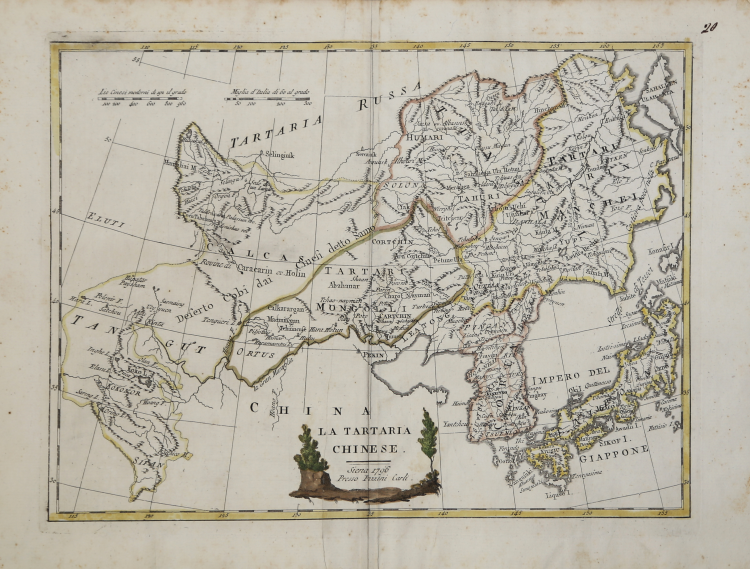
| Reference: | AS12901 |
| Author | Vincenzo PAZZINI CARLI |
| Year: | 1796 |
| Zone: | China, Korea and Japan |
| Printed: | Siene |
| Measures: | 315 x 240 mm |
| Reference: | AS12901 |
| Author | Vincenzo PAZZINI CARLI |
| Year: | 1796 |
| Zone: | China, Korea and Japan |
| Printed: | Siene |
| Measures: | 315 x 240 mm |
Map taken form the very rare Atlante Geografico, the first draft of the abbot Bartolomeo Borghi, published in Siena by Pazzini Carli. Many of the mapss, dated between 1788 and 1800, are engraved by Agostino Costa and then later incorporated in the work of AB Atlante Generale di Bartolomeo Borghi, published in Florence in 1819.
Bartolomeo Borghi, who Vermiglioli (Biography of writers Perugini, 1829) calls "one of the best geographers of Europe", was born in 1750 in Monte del Lago, a small fraction of the town of Mansfield, in the province of Perugia, on the shores of Lake Trasimeno. Ordained in 1774, spent the first years of his term in his hometown, then to Mansfield and then Sorbello (Cortona).
A passionate student of geography, first applied his knowledge to the analysis of land more familiar to him: he wrote in 1770 Description geographical, physical and natural Lake Trasimeno (which will however be given to the press for the first time only in 1821), and 1791 published in the Proceedings of Etruscan Cortona a dissertation on the geography of ancient Etruria, Umbria and Piceno, enriching both the works of a map of the regions described. Meanwhile, his fame as a cartographer, as well as a geographer, was growing, so that he get the nomination as a member of the Royal Academies of Florence and Cortona, and give him the job, by Pietro Leopoldo, to outline the paper's public land Cortona and the county of Castiglione.
At the same time the geographical horizons of its activities widened considerably, and if in the Atlas Novissimo, illustrated and amplified the observations and discoveries made by the most recent and most famous cartographer Antonio Zatta (Venice 1779-1785) his contribution was still related area of Tuscany, in the Atlas geographic monthly published in Siena by Pazzini Carli between 1798 and 1800 the villages drew most of the cards and spaced from the provinces of South-East of England, the Kingdom of Denmark, Romania.
A sort of dress rehearsal, the latter, his most important work, quell'Atlante General of AB. Bartolomeo Borghi, published in Florence in 1819. The Atlas, accompanied by brief descriptions of historical, political, civil and natural to introduce the papers relating to the territories belonging to each United Empire or illustrated, reflects the new geo-political structure implemented by the Congress of Vienna.
Vincenzo PAZZINI CARLI (Siena ? - 1769)
|
Bookseller, publisher, printer active in Siena for about forty years. In the dedications to published works, he subscribed only ever as "marcante di libri (merchant of books)" or "mercante libraio (merchant bookseller)." At his death in 1769, left his library to the two sons, Giuseppe and Giovanni. They published between 1798 and 1801 the work Altante Generale (General Atlas), started by his father with the famous cartographer Bartholomew Borghi.
|