| Reference: | s31375 |
| Author | François HALMA |
| Year: | 1697 ca. |
| Zone: | Castel Sant'Angelo |
| Printed: | Amsterdam |
| Measures: | 350 x 360 mm |
| Reference: | s31375 |
| Author | François HALMA |
| Year: | 1697 ca. |
| Zone: | Castel Sant'Angelo |
| Printed: | Amsterdam |
| Measures: | 350 x 360 mm |
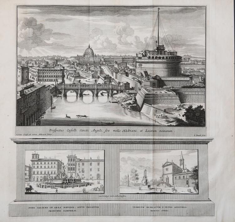
A splendid etching composed of two plates: a larger upper plate, engraved from a design by Lievin Cruyl, shows a wide panoramic view of the bridge and Castel Sant'Angelo, the Borgo district, and the Vatican City. The lower plate features two smaller views depicting the Moor Fountain in Piazza Navona and the church of San Pietro in Montorio on the Janiculum Hill, based on engravings by Giovanni Battista Falda.
The composition, based on a drawing by Lievin Cruyl, was first published in J. G. Graevius's "Thesaurus antiquitatum Romanarum", edited by Franz Halm and Peter van der AA between 1694 and 1699.
The series based on Cruyl's drawings, published by Franz Halm, consists of fifteen plates, either composed of multiple plates or divided into two parts. The upper section is based on Cruyl's drawings, while the lower section features subjects by Giovan Battista Falda. Only ten of these subjects were also engraved by Cruyl, first published in 1666 by Giovan Battista de Rossi in a volume dedicated to Pope Alexander VII, entitled Prospectus loco rum Urbis Romae Insignis, a work later reprinted by Matteo Gregorio de Rossi in 1692–98. Cruyl characterizes each of his views with the inclusion of figures perfectly aligned with the urban context and, at the same time, describes and defines existing monuments in Pope Chigi's city. To achieve his goal, the artist does not hesitate to alter the perspective or modify the urban space.
This example is taken from the work "Beschryving van oud en nieuw Rome" by François Jacques Deseine, published in Amsterdam in 1704 by Franz Halm. Contrary to what Bodart indicated and confirmed by Barbara Jatta in her essay on Cruyl, the engravings appear to be the same.
Lievin Cruyl (1640-1720), a Flemish perspective artist originally from Ghent, moved to Rome in 1644. Along with Giovan Battista Falda and Israel Silvestre, he was one of the innovators of the 17th-century Roman view. Although influenced by the 16th-century conception of the role of antiquity in the image of Rome, he represented the architectural and urban innovations of the Rome of Alexander VII (Fabio Chigi 1655-1667), characterizing his views with small scenes in the Flemish tradition. In his depictions of urban space, Cruyl altered the perspective, raising the viewpoint and expanding the field of vision, using the most advanced optical techniques of the time.
Etching and engraving, usual paper folds, otherwise in excellent condition.
Bibliografia
B. Jatta, Lievin Cruyl e la sua opera grafica, p. 161.
|
François Halma [Franz Halm, Franciscus Halma (1653 - 1722)] was a Dutch publisher active in Utrecht (starting 1674) and later in Amsterdam where he worked as printer and publisher from 1699-1710. He eventually settled at Leeuwarden, where he died. His output was composed of botanical, theological and historical works, but also, he published a small number of geographies and atlases. In 1695, he published an edition of Gerard Mercator's Ptolemy. His re-issue of Schotanus à Sterringa’s Friesche Atlas in 1698 was regarded among his finest work. He also published an edition of Sanson’s Description de l’Univers. He produced an edition of Falda's plan of Rome in or around 1700. He also caused to be engraved a set of large-format maps of the continents and the world (this latter after Cassini) which are quite rare and appear to have been separately issued. We are aware of institutional copies of the continents having been bound into a 1710 Visscher atlas. The execution of these large and rare maps, drawn by Jan Goeree and engraved by Jan Baptiste, was of a very high quality. The plates were later acquired and reprinted, virtually unchanged, by Pieter van der Aa in 1713.
|
|
François Halma [Franz Halm, Franciscus Halma (1653 - 1722)] was a Dutch publisher active in Utrecht (starting 1674) and later in Amsterdam where he worked as printer and publisher from 1699-1710. He eventually settled at Leeuwarden, where he died. His output was composed of botanical, theological and historical works, but also, he published a small number of geographies and atlases. In 1695, he published an edition of Gerard Mercator's Ptolemy. His re-issue of Schotanus à Sterringa’s Friesche Atlas in 1698 was regarded among his finest work. He also published an edition of Sanson’s Description de l’Univers. He produced an edition of Falda's plan of Rome in or around 1700. He also caused to be engraved a set of large-format maps of the continents and the world (this latter after Cassini) which are quite rare and appear to have been separately issued. We are aware of institutional copies of the continents having been bound into a 1710 Visscher atlas. The execution of these large and rare maps, drawn by Jan Goeree and engraved by Jan Baptiste, was of a very high quality. The plates were later acquired and reprinted, virtually unchanged, by Pieter van der Aa in 1713.
|