
| Reference: | S40056 |
| Author | Vincenzo CORONELLI |
| Year: | 1689 ca. |
| Zone: | Terrestrial Globe |
| Printed: | Venice |
| Measures: | 620 x 470 mm |
| Reference: | S40056 |
| Author | Vincenzo CORONELLI |
| Year: | 1689 ca. |
| Zone: | Terrestrial Globe |
| Printed: | Venice |
| Measures: | 620 x 470 mm |
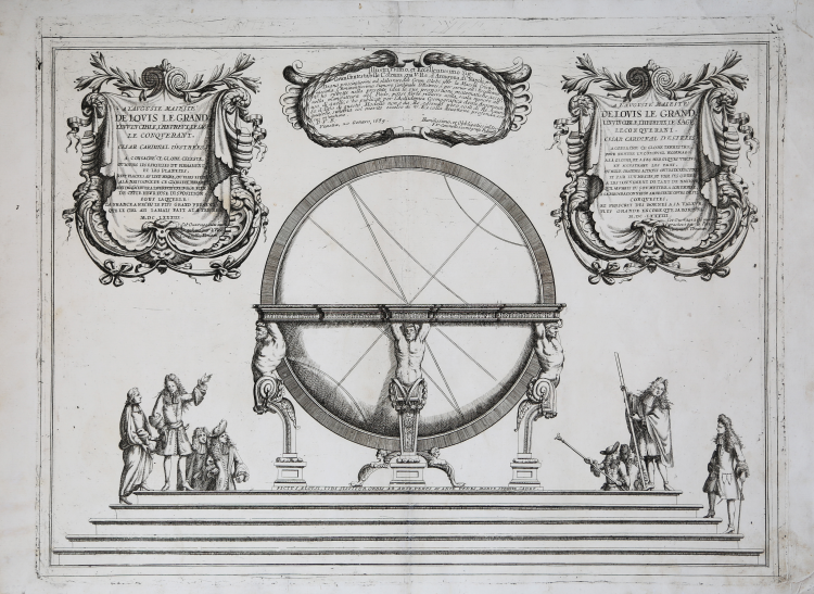
An engraving, by the renowned Venetian cartographer and globe maker Vincenzo Maria Coronelli, depicting members of the nobility studying astronomy before a huge globe mounted on a Baroque stand supported by three turbaned Atlas-like monopod term figures. The details of the actual globe surface are not depicted; instead the globe is depicted schematically with lines indicating the ecliptic, equator, tropics, and polar circles suggesting either a celestial or terrestrial globe. On the pedestal beneath globe is a Latin motto: “Fictus, Aloysi, Tibi Sistitur Orbis Ab Art, Verus At Ante Pedes, Mars, Iubente, Cadet.”
The globe shown in the engraving apparently represents the celebrated Marly Globes — a pair of gigantic and elaborate terrestrial and celestial globes commissioned from Coronelli to be presented to King Louis XIV of France. Indeed, the engraving has two elaborate Baroque cartouches in French above the scene containing dedications by Coronelli to Louis XIV. One refers to the celestial globe “where all the stars of the firmament and the planets are themselves placed, where they were at the birth of this glorious monarch.” The other refers to the terrestrial globe that would “pay a continual tribute to his glory, and to his heroic virtues, by showing the countries, or a thousand great actions [that] were executed” by him. A third elaborate Baroque cartouche — in Italian — has additional dedications to Coronelli’s patron Lorenzo Onofrio Colonna, Viceroy of Aragon and Naples, with reference to Cardinal César Duke d’Estrée, the French ambassador to Rome who paid Coronelli to make the Marly globes.
Example taken form Corenelli’s Atlante Veneto, Nel quale si contiene la Descrittione Geografica, Storica, Sacra, Profana e Politica degli Imperi, Regni, Provincie, e Santi dell’Universo […] In Venetia MDCXC.
Coronelli lived a period of extraordinary editorial fecundity starting from 1689, when he had the chair of geography at the University at the Procuratie, with the publication, in 1690, of the first volume of the Atlante Veneto. Under the name of Atlante Veneto goes the entire collection of thirteen works composed over the next decade, from the Isolario to the Specchio del mare.
The work was intended as an extension of Blaeu’s Atlas Maior. It is no mere collection of maps, but rather “a compendium of geographical, cosmographical, and scientific information... on contemporary Italian science and geography” (Scammell). As well as maps, the first volume includes several of Coronelli’s celebrated naval plates, many with the separately-printed “Farnese” borders especially commissioned by Coronelli’s patron, Ranuccio II Farnese, Duke of Parma.
Copperplate, with full margins, very good condition. Very rare.
Literature
Ermanno Armao, Vincenzo Coronelli (Florence, 1944), no.59, no.60 and p.237.
Vincenzo CORONELLI (Venezia 1650 - 1718)
|
Cosmographer, geographer, biographer, encyclopedist, globe maker, inventor, expert of engeneering and hydraulics. Extraordinarily versatile mind and an extremely tireless man, he produced more than 140 pieces in different genres. At the age of 15, he entered the Franciscan Order, which he then guided as Gran Generale from 1699. He became famous as geographer and mathematician, awakening the interest in these subjects in Italy at the end of the XVII century. He travelled a lot, seeking for all that was new, and keeping a correspondance with the most important intellectuals of his time. In 1681 Louis XIV wanted him to go to France, to entrust him with the task of making two terraqueous globes (Marly Globes), with a diameter of 4 metres. Once he came back to Italy, in 1685, he became Cosmographer of the Venetian Republic, where he taught geography and founded the first geographic accademy, called The Argonauts Accademy. In his whole life he produced more that 500 maps; some of them can be found in his most famous works, such as the Venetian Atlas (1690), the Island Book of the Venetian Atlas (1696-97), the Book of Globes (1693). As far as his scientific method, he didn’t elaborate new cartographic systems, but followed the theories that were considered most popular and effective at his time, based on the Copernican system. The main characteristic of his charts is the high quantity of toponymic and historical information. In his most famous and dense work, the Venetian Atlas, we can find about 1100 plates, 200 of which are extremely technical and this is the reason why it is considered the first Italian atlas to describe and illustrate the whole world with charts and maps. It was published in 13 volumes, starting from 1690, and it took nearly ten years to finish it. It is divided in different parts, the most important are the Atlas itself, then the Island Book, the Corso Geografico and the Teatro delle città.
|