| Reference: | S39995.83 |
| Author | Pierre DUVAL |
| Year: | 1656 ca. |
| Zone: | West Africa |
| Printed: | Paris |
| Measures: | 120 x 100 mm |
| Reference: | S39995.83 |
| Author | Pierre DUVAL |
| Year: | 1656 ca. |
| Zone: | West Africa |
| Printed: | Paris |
| Measures: | 120 x 100 mm |
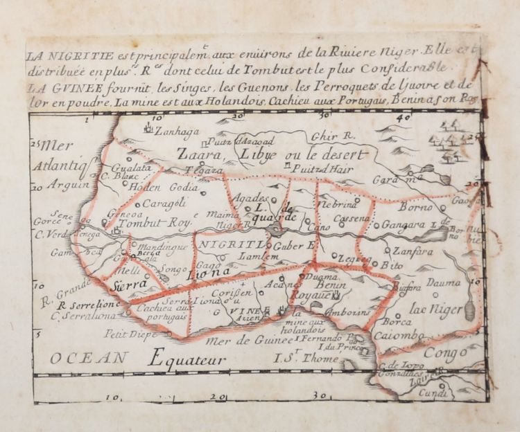
Etching, circa 1656, with contemporary outline colour, good condition.
Example of the second state of three, with the imprint of Jacques Lagniet and the date 1661.
The map comes from the very rare sheet entitled “L’Afrique Par le Sieur Du Val Geographe Ord. du Roy a Paris”, from which it was cut at the time and laid down on contemporary laid paper support, to form a small atlas, as certified by the ancient ink inscriptions on some of the maps.
According with Philip Burden “The purpose of this rare curiosity by Pierre Duval is not known. It forms part of a set of the four known continents. It can be dated to apporximately 1656 […] The second state bears the additional imprint of Jacques Lagniet and the date 1661”. (cf. Burden, The Mapping of North America, pp. 417-418, n. 322).
Richard Betz describes 3 states of this broadsheet: without the date, with the imprint of Jacques Lagniet and the date 1661, and with traces of erasure on his address.
“This is an unusual map sheet by Pierre Duval depicting a map of the entire African continent and 14 reagional maps of Africa. […] This map of Africa is part of a set of four continent maps with regional maps procuded by Duval, all of which are scarce. […] Considering the small size of the map, Duval was able to supply a surprisngly high degree of detail to it. Duval used his unclu Nicolas Sanson’s 1650 map of Africa as his model, though in this map, Duval omits the lake in the Abyssinian highlands that was to eventually became Lake Tana, the source for the Blue Nile river. (cf. Betz, The Mapping of Africa, pp. 294, 295).
According with Betz the only example of the first state of the broadsheet is preserved in the British Library collection, while 3 copies of the second state are known (Bibliotheque National de France, McLaughlin Map Collection and Bedburg-Hau, Antiquariat Haas – now sold).
|
Betz, The Mapping of Africa, pp. 294, 295, n. 85; cf. Burden, The Mapping of America, n. 322, II/II; cf. Pastoureau (1984) p. 136; cf. J. Hubbard, Japoniae Insulae. The Mapping of Japan, pp. 199-201, n. 28.
|
Pierre DUVAL(1618 - 1683)
|
Betz, The Mapping of Africa, pp. 294, 295, n. 85; cf. Burden, The Mapping of America, n. 322, II/II; cf. Pastoureau (1984) p. 136; cf. J. Hubbard, Japoniae Insulae. The Mapping of Japan, pp. 199-201, n. 28.
|
Pierre DUVAL(1618 - 1683)