| Reference: | S40972 |
| Author | Giovanni Antonio MAGINI |
| Year: | 1598 ca. |
| Zone: | Verona |
| Printed: | Bologna |
| Measures: | 465 x 345 mm |
| Reference: | S40972 |
| Author | Giovanni Antonio MAGINI |
| Year: | 1598 ca. |
| Zone: | Verona |
| Printed: | Bologna |
| Measures: | 465 x 345 mm |
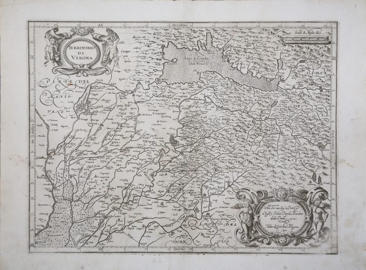
In alto, nel cartiglio a sinistra, il titolo TERRITORIO DI VERONA; a destra la scala grafica Scala di Miglia dieci (10 miglia pari a mm 60). Nel cartiglio in basso a destra, dove si notano delle abrasioni è incisa la dedica: All’ Ill.mo mio Sig:r et P[at]ron[us] Col.o il Sig:r Co: Fabio Pepoli Marchese della Preda & c. Fabio di Gio[vanni] Ant.o Magini. Orientazione nei quattro lati al centro con il nome dei punti cardinali Septentrio, Meridies, Oriens, Occidens, il nord a destra. Graduazione ai margini di 1’ in 1’ da 44° 45’ a 45° 51’ di latitudine, e da 32° 50’ a 34° 10’’ di longitudine.
“Del territorio veronese non conosciamo carte manoscritte anteriori alla metà del secolo XVI. La carta maginiana deriva dalla più antica carta a stampa di tale territorio, quella di Bernardino Brognolo, perito dei beni inculti, architetto e scrittore, edita a Venezia da Paolo Furlani nel 1574, più tardi altre volte ripubblicata, inserita anche, in dimensioni ridotte, nella edizione 1601 del Theatrum dell'Ortelio, utilizzata da Mercator per la carta Veronae, Vicentiae et Patavii ditiones. Anche in questo caso le analogie sono strettissime, così per la idrografia, come per la situazione e nomenclatura dei centri abitati, non solo per tutto il territorio veronese propriamente detto, ma anche per la riva bresciana del lago di Garda e per il Trentino a valle di Trento. Magini ha soppresso le strade che figurano nella carta del Brognolo ha poi introdotto qualche correzione sul rame nell'area a nord di Mantova” (cfr. R. Almagià, L'Italia di Giovanni Antonio Magini e la Cartografia dell'Italia nel secolo XVI e XVII (1922), p. 38).
Carta geografica tratta dal L’Italia a cura di Fabio Magini, edito a Bologna nel 1620, tre anni dopo la prematura morte del padre.
Composta da un breve testo descrittivo di sole 24 carte, l’opera è corredata di 61 carte geografiche della penisola, e costituisce il primo esempio di atlante italiano. L’opera è per intero di mano del Magini, che iniziò la realizzazione delle carte nel 1594 circa, dando alla luce per prima nel 1595 la carta del territorio di Bologna. Tutte le carte vennero alle stampe quindi prima del 1620, nelle loro stesure provvisorie, successivamente corrette ed aggiornate per l’edizione definitiva. Per la realizzazione delle lastre il Magini si servì di due dei più famosi intagliatori dell’epoca: il belga Arnoldo Arnoldi e l’inglese Benjamin Wright.
Bibliografia
R. Almagià, L'Italia di Giovanni Antonio Magini e la Cartografia dell'Italia nei secoli XVI e XVII (1922): pp. 36-48, n. 7.
Giovanni Antonio MAGINI (1555 - 1617)
|
Giovanni Antonio Magini was born in Padua in 1555, dedicating himself to the study of astronomy from an early age. In 1588 the Senate of Bologna appointed him Lecturer of Astronomy at the local University, choosing him instead of Galileo Galilei. His friendship with the Duke of Mantua, Vincenzo Gonzaga, helped Magini in his quest to obtain cartographical material for map-making from the various sovereigns ruling the different Italian states at that time. Because of Magini's early death in 1617, this effort was made famous by his son Fabio when he published the atlas "L'Italia" in Bologna in 1620. This is the first example of an Italian atlas and is made up of 24 pages of descriptive text and 61 maps of the Italian peninsula. Although this work was published posthumously, it can be entirely ascribed to Magini. He began drawing this maps around 1594, with the one depicting Bologna and its surrounding territories being the first. They were all printed before 1620 in draft editions which were then revised and updated for the final version. These draft proofs are extremely rare, although sometimes available for sale, and exhibit substantial differences in respect to the maps finally included in the atlas. Two of the most famous engravers of the time, Arnoldo Arnoldi and the englishman Benjamin Wright, were entrusted by Magini to engrave the plates. As we shall see in the presentation of the separate maps, they derive from different sources, both known and unknown, and therefore represent the result of an original work of critical analysis and compilation. This atlas had an important influence on the cartography of the italian peninsula for the following two centuries, beginning from Ortelius and going on to the principal dutch cartographers and editors.
|