
- New
| Reference: | S29414 |
| Author | Pieter VANDER AA |
| Year: | 1713 |
| Zone: | Veneto |
| Printed: | Leyden |
| Measures: | 400 x 270 mm |
| Reference: | S29414 |
| Author | Pieter VANDER AA |
| Year: | 1713 |
| Zone: | Veneto |
| Printed: | Leyden |
| Measures: | 400 x 270 mm |
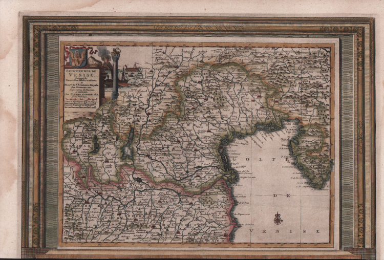
Map from "La Galerie agreable du monde," published in Leiden in 1713.
The map covers in detail the mainland dominions of the Serenissima (present-day Veneto, part of Friuli, and eastern Lombardy up to Bergamo), showing its complex hydrography (including Lake Garda) and the coastline overlooking the Gulf of Venice.
Created by the renowned Dutch publisher and geographer Pieter van der Aa in Leiden, originally published around 1713, this copy is enriched by a decorative frame. In the upper left corner is an elegant baroque cartouche bearing the full title ("Seigneurie de Venise, Suivant les Nouvelles Observations de Messrs. de l'Academie Royale des Sciences..."), surmounted by allegorical and historical elements associated with Venetian power, including a column reminiscent of those in Piazza San Marco.
Etching, finely hand-colored, in excellent condition.
Pieter VANDER AA (1659 - 1733)
|
Records show that van der Aa, born in Leyden in 1659, made an early start in life by being apprenticed to a bookseller at the age of nine and starting on his own in business as a book publisher by the time he was twenty-three.
During the following fifty years he published an enormous amount of material, including atlases and illustrated works in every shape and size, two of them consisting of no less than 27 and 28 volumes containing over 3,000 maps and plates.
Most of his maps were not of the first quality and were certainly not original, but they are often very decorative and are collected on that account.
|
Pieter VANDER AA (1659 - 1733)
|
Records show that van der Aa, born in Leyden in 1659, made an early start in life by being apprenticed to a bookseller at the age of nine and starting on his own in business as a book publisher by the time he was twenty-three.
During the following fifty years he published an enormous amount of material, including atlases and illustrated works in every shape and size, two of them consisting of no less than 27 and 28 volumes containing over 3,000 maps and plates.
Most of his maps were not of the first quality and were certainly not original, but they are often very decorative and are collected on that account.
|