
| Reference: | S4691 |
| Author | Didier Robert de VAUGONDY |
| Year: | 1772 |
| Zone: | California |
| Printed: | Paris |
| Measures: | 375 x 315 mm |
| Reference: | S4691 |
| Author | Didier Robert de VAUGONDY |
| Year: | 1772 |
| Zone: | California |
| Printed: | Paris |
| Measures: | 375 x 315 mm |
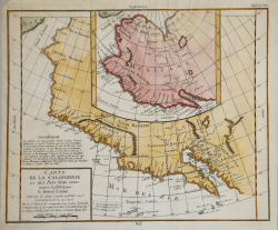
Fascinating study in the comparative cartography of the West Coast of North America, from the Straits of Anian to Cabo San Lucas and the southern tip of Baja California. The work consists of extracts from two maps, both reportedly done by Visscher in the 1612 and 1641 respectively and with information derived from Mercator and Plancius. The larger map prominently shows the Strait of Anian, Anian Regnum, Quivira Regnum, the Sierra Nevada, Nova Albion, Tontonteac Regnum, Tolm Regnum and a coastal detail which includes over 30 coastal place names, including Mendocino, San Miguel (San Diego), Cape Fortuna, I. De Paxaros (Catalina?), and many mythical/ephemeral place names. The smaller map also shows the Straits of Anian, but depicts an open sea above, clearly portending a NW Passage in the Arctic Circle.
The NW Coastline differs radically, and only Anian Regnum and Quivira Regnum are located, that later considerably south of the location on the larger map. The smaller map includes a similar number of coastal placenames, but includes several important ones not listed on the larger map, including C. Blanco (3 times), C. de San Francisco and los Farilones, but ommits any significant effort to depict bays. Diderot's work is part of a 10 map supplement to his Encyclopedia, and provides one of the most fascinating studies in contemporary comparative cartography which can be obtained by collectors, much of which is dedicated to the NW Coast.
This map is part of the 10 map series prepared by Vaugondy for the Supplement to Diderot's Encyclopédie, of which this is plate 2. This seminal map series, exploring the mapping of North American and specifically the Northwest Passage was one of the first studies in comparative cartography.
Copperplate, fine later hand colour, very good condition.
Didier Robert de VAUGONDY (1723 ca. - 1786)
|
Didier Robert de Vaugondy (1723-1786) was appointed Geographer to Louis XV in 1760. At the same time, de Vaugondy served as Geographer to the Duke of Lorraine and Bar, father-in-law to Louis XV and former King of Poland.
His major contributions to French cartography are the Atlas Universel, 1750-57, The Nouvelle Atlas Portatif (1784) and a very popular map of North America published in 1761. He was son of Gilles Robert de Vaugondy who succeeded Pierre Sanson as the King's Geographer.
|