| Reference: | S44859 |
| Author | Johannes de Laet |
| Year: | 1630 ca. |
| Zone: | Florida |
| Printed: | Amsterdam |
| Measures: | 360 x 285 mm |
| Reference: | S44859 |
| Author | Johannes de Laet |
| Year: | 1630 ca. |
| Zone: | Florida |
| Printed: | Amsterdam |
| Measures: | 360 x 285 mm |
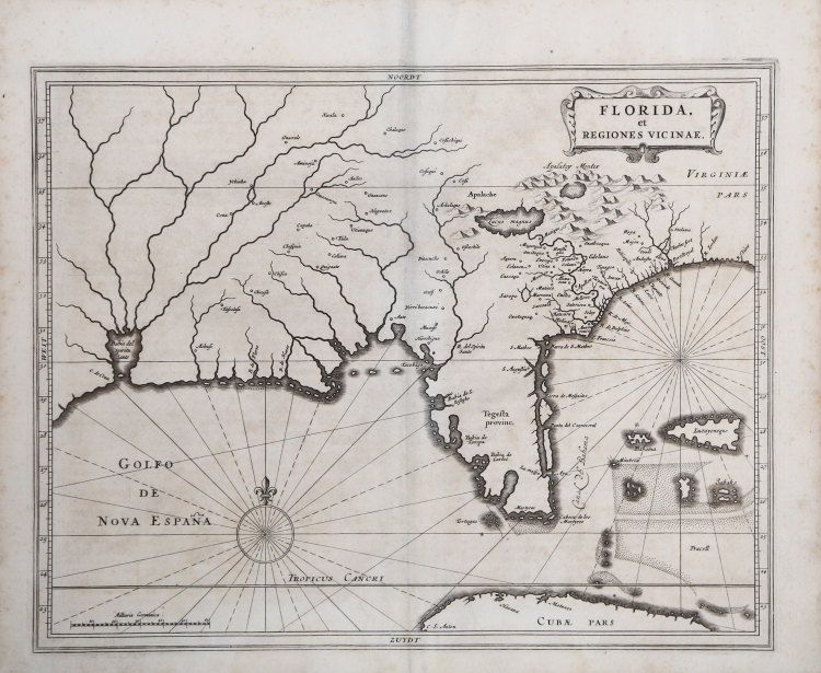
Important map of the southeastern part of North America published by Joannes De Laet in Amsterdam.
The map was almost certainly engraved by Hessel Gerritsz, based on Cornelis Claesz's 1602 work and Jacques Le Moyne's map of Florida, with nomenclature taken from Chaves' 1584 manuscript map. It covers the Atlantic coast and interior of North America from South Carolina to about Galveston Bay in Texas. De Laet and Gerritsz drew on several sources for the map's contents, including the work of Cornelis Claesz and that of Jacques le Moyne for Florida. One noteworthy improvement is C. Francois' placement further east in the Atlantic Ocean. Florida is referred to as "Tegesta provinc" the first appearance of the name Tegesta, derived from the names of Native Americans who lived on the southwest coast.
De Laet's map became the cartographic model for the region, later copied by Blaeu, Janssonius, Sanson and most other commercial map publishers in the decades following its publication.
De Laet's map appeared in his seminal work on America, which is widely regarded as the most important and influential treatise on the subject published in the 17th Century, the Novus Orbis seu descriptionis Indiae occidentalis Libri XVIII printed in Lugduni Batavorum: Elzevir, 1633.
Third edition of one of the most important of seventeenth-century New World voyages collections, compiled by a director of the recently formed Dutch West India Company, Johannes de Laet (1581-1649). Previous editions were published: the first in Antwerp in Dutch (1625), the second edition-the first in Latin-in Leiden, in 1630, also by the publisher Elzevir.
This issue include for the first time four American regional maps: "Americae sive Indiae Occidentalis", the best West Coast delineation to date, and interestingly depicting California as a peninsula not an island, and stopping short of the controversial region of the North West Passage; "Nova Francia et Regiones Adiacentes", one of the foundation maps of Canada, the first printed map to include an accurate depiction of Prince Edward Island, and the earliest of a north-south oriented Lake Champlain, and still relied upon by Blaeu in 1662 and Coronelli in the 1690s; "Nova Anglia" is of "extreme importance being the first printed one to use the names "Manbattes" (Manhattan), and "N. Amsterdam", or New York, founded in 1626. It is also the earliest to use the Dutch names of "Noordt Rivier" and "Zuyd Rivier", for the Hudson and Delaware Rivers respectively, as well as the Indian "Massachusetts", for the new English colony" (Burden); and "Florida, et regions vicinae" a largely derivative map with one notable alteration in the "placing of "C.Francois" further east into the Atlantic Ocean. Florida, as we know it today, is here called "Tegesta Provinc." This name, applied here for the first time, is that of a tribe of Indians living on the south-west coast. "Florida" was at this time applied to a far larger region" (Burden).
A fine impression, on contemporary laid paper, very good condition.
Bibliografia
Burden, P., The Mapping of North America, n. 232; Cumming, The Southeast in Early Maps, n. 34.
Johannes de Laet(1581 - 1649
Johannes de Laet(1581 - 1649