| Reference: | CO-255 |
| Author | Georg BRAUN & Franz HOGENBERG |
| Year: | 1598 |
| Zone: | Acquapendente, Treviso |
| Printed: | Antwerpen & Cologne |
| Measures: | 495 x 370 mm |
| Reference: | CO-255 |
| Author | Georg BRAUN & Franz HOGENBERG |
| Year: | 1598 |
| Zone: | Acquapendente, Treviso |
| Printed: | Antwerpen & Cologne |
| Measures: | 495 x 370 mm |
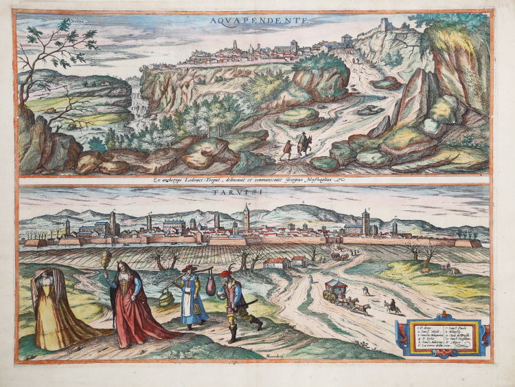
Sheet containing perspective views of Acquapendente and Treviso. The work is included in Civitates Orbis Terrarum, the first atlas devoted exclusively to plans and views of the world's major cities.
View of Acquapendente by G. Hoefnagel after Ludovico Toeput. The view from the west highlights the town's dramatic location on a precipitous rock terrace. On the left of the town lies the cathedral of San Sepolcro and in the centre the church of San Francesco, whose prominent bell tower dates from the Renaissance. On top of the hill on the far right lies the Monastero di Santa Chiara, built in 1333 on a site formerly occupied by an imperial fortress. Acquapendente, which in 1499 became part of the Papal States, lies north of the Lake Bolsena on the road that leads from Siena to Rome via Viterbo.
The fortified city of Treviso is seen from the south, in its picturesque setting on the banks of the Sile River with the Alps (11) in the background. The tallest tower in the city is the Torre del Comune (6) on the Piazza dei Signori, which is surrounded by palaces with open arcades. Further left is the cathedral of San Pietro (1). Further left again is the Dominican church of San Nicolò. Commentary by Braun: “Treviso is a noble town in the March of Treviso and very famous in the history of the Goths, since the father of King Totila, who ruled in Verona and Treviso, took particular delight in this town and lived there himself, and his son Totila, who later became king of the Ostrogoths, was born and educated there. The city of Treviso has all the necessities of life in abundance, for it is very well supplied with grain, wine, other fruits and cattle. In the city on the River Sile there are very many drinking fountains and magnificent buildings and houses.”
The work is included in the Civitates Orbis Terrarum, the first atlas devoted exclusively to plans and views of the world's major cities. Printed in six volumes between 1572 and 1617 it was so successful and widespread that several editions translated into Latin, German and French were printed.
The first volume of the Civitates Orbis Terrarum was published in Cologne in 1572. The sixth and the final volume appeared in 1617. This great city atlas, edited by Georg Braun and largely engraved by Franz Hogenberg, eventually contained 546 prospects, bird-eye views and map views of cities from all over the world. Fransz Hogenberg produced the plates for the first four books, and Simon van den Neuwel (Novellanus, active since 1580) those for volumes V and VI.
Georg Braun (1541-1622), a cleric of Cologne, was the principal editor of the work, and was greatly assisted in his project by the close, and continued interest of Abraham Ortelius, whose Theatrum Orbis Terrarum of 1570 was, as a systematic and comprehensive collection of maps of uniform style, the first true atlas. The Civitates, indeed, was intended as a companion for the Theatrum, as indicated by the similarity in the titles and by contemporary references regarding the complementary nature of two works. Nevertheless, the Civitates was designs to be more popular in approach, no doubt because the novelty of a collection of city plans and views represented a more hazardous commercial undertaking than a world atlas, for which there had been a number of successful precedents. Franz Hogenberg (1535-1590) was the son of a Munich engraves who settled in Malines. He engraved most of the plates for Ortelius's Theatrum and the majority of those in the Civitates, and may have been responsible for originating the project.
Over a hundred of different artists and cartographers, the most significant of whom was Antwerp artist Georg Hoefnagel (1542-1600), engraved the cooper-plates of the Civitates from drawings. He not only contributed most of the original material for the Spanish and Italian towns but also reworked and modified those of other contributors. After Hoefnagel's death his son Jakob continued the work for the Civitates.
The author set out to depict "non icones et typi urbium," that is, not generic and typified images, "sed urbes ipsae admirabili caelaturae artificio, spectantium oculis subiectae appareant": not intended to allude or idealize but to represent faithfully on paper, to reproduce exactly, and in real time, what the eye sees, as announced in the preface to the first volume of Civitates Orbis Terrarum.
Copperplate, with fine later hand colour, very good condition.
|
George Braun (1541-1622), cleric of Cologne, was the principal editor of the Civitates Orbis Terrarum, and was greatly assisted in his project by the close, and continued interest of Abraham Ortelius, whose Theatrum Orbis Terrarum of 1570 was, as a systematic and comprehensive collection of maps of uniform style, the first true atlas.
Franz Hogenberg (1535-1590) was the son of a Munich engraves who settled in Malines. He engraved most of the plates for Ortelius's Theatrum and the majority of those in the Civitates, and may have been responsible for originating the project.
|
|
George Braun (1541-1622), cleric of Cologne, was the principal editor of the Civitates Orbis Terrarum, and was greatly assisted in his project by the close, and continued interest of Abraham Ortelius, whose Theatrum Orbis Terrarum of 1570 was, as a systematic and comprehensive collection of maps of uniform style, the first true atlas.
Franz Hogenberg (1535-1590) was the son of a Munich engraves who settled in Malines. He engraved most of the plates for Ortelius's Theatrum and the majority of those in the Civitates, and may have been responsible for originating the project.
|