
- New
| Reference: | S2685 |
| Author | Pierre MORTIER |
| Year: | 1704 |
| Zone: | Piombino |
| Printed: | Amsterdam |
| Measures: | 540 x 450 mm |
| Reference: | S2685 |
| Author | Pierre MORTIER |
| Year: | 1704 |
| Zone: | Piombino |
| Printed: | Amsterdam |
| Measures: | 540 x 450 mm |
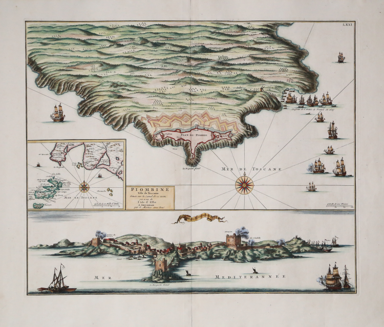
A spectacular cartographic composition dedicated to the fortified city of Piombino, an ancient and strategic principality on the Tuscan coast. The work is structured across three visual registers. At the top is a detailed plan of the Piombino peninsula, focusing on the complex bastion structure and the citadel's fortifications. The surrounding sea is animated by baroque vessels and warships, complemented by compass rose lines. In the center left panel is a nautical orientation chart showing the Tyrrhenian coast, the Piombino Channel, and the facing island of Elba. Below is a panoramic view of the city from the sea. The coastal profile highlights the fortifications overlooking the sea, the watchtowers, the port, and the orography of the inland territory, offering a valuable testimony to the military architecture of the period.
The map is taken from the first volume of the "Nouveau Theatre de l'Italie" published in Amsterdam in 1704/5 and 1724, as a supplement to Johannes Blaeu's project, begun in 1663, for the large "town book" which lacked plans of much of the northern part of the peninsula. However, it is likely assumed that the plates of Tuscany had already been engraved by Joan Blaeu for the planned Teatro del Granducato di Toscana before the Blaeu’s printing house burned down. Upon its liquidation, they were purchased by Mortier, who published them in his Nouveau Theatre de l'Italie.
During his long editorial career, Blaeu published three volumes on Italian cities. The first three, divided into the Papal States, Rome, and the Kingdom of Naples and Sicily, were published in 1663. Upon his death, his heirs published two further volumes, dated 1682, focusing on the cities of Piedmont and Savoy, which were later reprinted by other publishers in 1693 and 1697. The Frenchman Pierre Mortier published a reprint in 1704/5, entitled "Nouveau Théâtre de l'Italie".
The work is in four volumes and includes Blaeu's plates, slightly retouched and modified, supplemented by the addition of numerous new maps of his own design, depicting the cities of the northern part of the peninsula, included in the first volume of the work.
Mortier's atlas was published with Latin, French, and Dutch texts. The distinguishing feature of the two editions by Blaeu and Mortier is that the text is not on the verso of the individual maps (which are therefore blank on the back), but at the beginning of each volume. The work's great success prompted a further, virtually identical reprint, edited by R. Alberts and published in 1724/5.
Etching, finely hand-colored, in excellent condition.
Bibliografia
Cremonini pp. 83-90.
|
Pierre Mortier (January 26, 1661 - February 18, 1711) or Pieter Mortier was a cartographer, engraver, and print seller active in Amsterdam during the later 17th and early 18th centuries. Mortier, then known as Pieter, was born in Leiden. He relocated to Paris from 1681 to 1685, adopting the French name Pierre, which he retained throughout his career. While in France, he developed deep French connections by bringing sophisticated Dutch printing technology and experience to nascent French map publishers such as Guillaume De L'Isle (1675 - 1726), Alexis-Hubert Jaillot (c. 1632 - 1712), and Nicholas de Fer (1646 - 1720). Consequently, much of Mortier's business was built upon issuing embellished high quality editions of contemporary French maps - generally with the permissions of their original authors. In the greater context of global cartography, this was a significant advantage as most Dutch map publishes had, at this point, fallen into the miasma of reprinting their own outdated works. By contrast, the cartographers of France were producing the most accurate and up to date charts anywhere. Mortier's cartographic work culminated in the magnificent nautical atlas, Le Neptune Francois. He was awarded the Privilege, an early form of copyright, in 1690. Upon Pierre's death in 1711 this business was inherited by his widow. In 1721, his son Cornelius Mortier took over the day to day operation of the firm. Cornelius partnered with his brother-in-law Jean Covens to form one of history's great cartographic partnerships - Covens and Mortier - which continued to publish maps and atlases until about 1866.
|
|
Pierre Mortier (January 26, 1661 - February 18, 1711) or Pieter Mortier was a cartographer, engraver, and print seller active in Amsterdam during the later 17th and early 18th centuries. Mortier, then known as Pieter, was born in Leiden. He relocated to Paris from 1681 to 1685, adopting the French name Pierre, which he retained throughout his career. While in France, he developed deep French connections by bringing sophisticated Dutch printing technology and experience to nascent French map publishers such as Guillaume De L'Isle (1675 - 1726), Alexis-Hubert Jaillot (c. 1632 - 1712), and Nicholas de Fer (1646 - 1720). Consequently, much of Mortier's business was built upon issuing embellished high quality editions of contemporary French maps - generally with the permissions of their original authors. In the greater context of global cartography, this was a significant advantage as most Dutch map publishes had, at this point, fallen into the miasma of reprinting their own outdated works. By contrast, the cartographers of France were producing the most accurate and up to date charts anywhere. Mortier's cartographic work culminated in the magnificent nautical atlas, Le Neptune Francois. He was awarded the Privilege, an early form of copyright, in 1690. Upon Pierre's death in 1711 this business was inherited by his widow. In 1721, his son Cornelius Mortier took over the day to day operation of the firm. Cornelius partnered with his brother-in-law Jean Covens to form one of history's great cartographic partnerships - Covens and Mortier - which continued to publish maps and atlases until about 1866.
|