
| Reference: | S40059 |
| Author | Johannes BLAEU |
| Year: | 1662 |
| Zone: | Nova Zamblja |
| Printed: | Amsterdam |
| Measures: | 500 x 375 mm |
| Reference: | S40059 |
| Author | Johannes BLAEU |
| Year: | 1662 |
| Zone: | Nova Zamblja |
| Printed: | Amsterdam |
| Measures: | 500 x 375 mm |
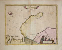
Map shows the russian Nowaja Semlja (Nova Zembla) in the Arctic ocean, the peninsula Jamal and the Obbussen, with two decorative cartouches.
Novaya Zemlya also known as Nova Zembla is an archipelago in the Arctic Ocean in northern Russia and the extreme northeast of Europe, the easternmost point of Europe lying at Cape Flissingsky on the Northern island. West of Novaya Zemlya is the Barents Sea, and to the east is the Kara Sea.
The Dutch were the most persistent searchers after the north-east Passage, whether to the north of Novaya Zemlya (whose west coast is shown in detail) or through what they called Nassau Straits to its south.
The Russians knew of Novaya Zemlya from the 11th century, when hunters from Novgorod visited the area. For Western Europeans, the search for the Northern Sea Route in the 16th century led to its exploration. The first visit from a Western European was by Hugh Willoughby in 1553.
Dutch explorer Willem Barentsz reached the west coast of Novaya Zemlya in 1594, and in a subsequent expedition of 1596, he rounded the northern cape and wintered on the northeastern coast. Barentsz died during the expedition, and may have been buried on Severny Island. During a later voyage by Fyodor Litke in 1821?1824, the western coast was mapped. On Gerhards Mercator large world map from 1597 , it is alredy named as Nova Zemla. Henry Hudson was another explorer who passed through Novaya Zemlya while searching for the Northeast Passage.
The work appears for the first time in Johannes Blaeu's "Atlas Major", 1662. This exemple is without text on verso, and is probably published by Johannes's sons after his death.
Copper engraving, iwith fine original colouring, very good condition.
|
cfr. A. Berkhemer, 'De Spaanse Atlas Mayor van Blaeu: nieuwe gegevens', Caert-Thresoor 16 (1997) 3, pp.71-76, H. De la Fontaine Verwey, The 'Spanish Blaeu,' Quaerendo 11 (1981), pp.83-94.
|
Johannes BLAEU (Alkmaar 1596 circa - Amsterdam 1663)
|
Joan Blaeu was the eldest son of Willem Janszoon Blaeu (1571-1638), and was probably born in Alkmaar in the province of Noord-Holland in the final years of the 16th century. He was brought up in Amsterdam, and studied law at the University of Leiden before going into partnership with his father in the 1630s. He became chief cartographer to the Dutch East India Company from 1638, and from 1651 to 1672 he served on the Amsterdam City Council without a break, holding several public offices. He also invested in Dutch colonial interests in North America. Joan Blaeu main work was Theatrum Orbis Terrarum (or Atlas Maior as it had became known.) Atlas had expanded to between 9 and 12 volumes, depending on the language. With over 3,000 text pages and approximately 600 maps, it was the most expensive book money could buy in the later 17th century. In 1638 Willem Blaeu died and the business passed into the hands of his sons, Joan and Cornelis, who continued and expanded their father's ambitious plans. After the death of Cornelis, Joan directed the work alone and the whole series of 6 volumes was eventually completed about 1655. As soon as it was finished he began the preparation of the even larger work, the Atlas Major, which reached publication in 1662 in II volumes (later editions in 9-12 volumes) and contained nearly 6oo double-page maps and 3,000 pages of text. This was, and indeed remains, the most magnificent work of its kind ever produced; perhaps its geographical content was not as up-to-date or as accurate as its author could have wished, but any deficiencies in that direction were more than compensated for by the fine engraving and colouring, the elaborate cartouches and pictorial and heraldic detail and especially the splendid calligraphy. In 1672 a disastrous fire destroyed Blaeu's printing house in the Gravenstraat and a year afterwards Joan Blaeu died. The firm's surviving stocks of plates and maps were gradually dispersed, some of the plates being bought by F. de Wit and Schenk and Valck, before final closure in about 1695.
|
|
cfr. A. Berkhemer, 'De Spaanse Atlas Mayor van Blaeu: nieuwe gegevens', Caert-Thresoor 16 (1997) 3, pp.71-76, H. De la Fontaine Verwey, The 'Spanish Blaeu,' Quaerendo 11 (1981), pp.83-94.
|
Johannes BLAEU (Alkmaar 1596 circa - Amsterdam 1663)
|
Joan Blaeu was the eldest son of Willem Janszoon Blaeu (1571-1638), and was probably born in Alkmaar in the province of Noord-Holland in the final years of the 16th century. He was brought up in Amsterdam, and studied law at the University of Leiden before going into partnership with his father in the 1630s. He became chief cartographer to the Dutch East India Company from 1638, and from 1651 to 1672 he served on the Amsterdam City Council without a break, holding several public offices. He also invested in Dutch colonial interests in North America. Joan Blaeu main work was Theatrum Orbis Terrarum (or Atlas Maior as it had became known.) Atlas had expanded to between 9 and 12 volumes, depending on the language. With over 3,000 text pages and approximately 600 maps, it was the most expensive book money could buy in the later 17th century. In 1638 Willem Blaeu died and the business passed into the hands of his sons, Joan and Cornelis, who continued and expanded their father's ambitious plans. After the death of Cornelis, Joan directed the work alone and the whole series of 6 volumes was eventually completed about 1655. As soon as it was finished he began the preparation of the even larger work, the Atlas Major, which reached publication in 1662 in II volumes (later editions in 9-12 volumes) and contained nearly 6oo double-page maps and 3,000 pages of text. This was, and indeed remains, the most magnificent work of its kind ever produced; perhaps its geographical content was not as up-to-date or as accurate as its author could have wished, but any deficiencies in that direction were more than compensated for by the fine engraving and colouring, the elaborate cartouches and pictorial and heraldic detail and especially the splendid calligraphy. In 1672 a disastrous fire destroyed Blaeu's printing house in the Gravenstraat and a year afterwards Joan Blaeu died. The firm's surviving stocks of plates and maps were gradually dispersed, some of the plates being bought by F. de Wit and Schenk and Valck, before final closure in about 1695.
|