| Reference: | S39536 |
| Author | Johann Matthias HASE |
| Year: | 1743 |
| Zone: | Russia |
| Printed: | Utrecht |
| Measures: | 560 x 520 mm |
| Reference: | S39536 |
| Author | Johann Matthias HASE |
| Year: | 1743 |
| Zone: | Russia |
| Printed: | Utrecht |
| Measures: | 560 x 520 mm |
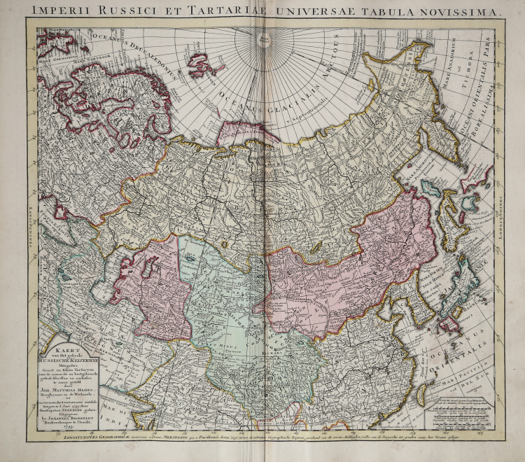
Decorative and rare map covering Russia, Tibet, China, Tartary, Korea, Taiwan and Japan prepared by J. M. Hasius. The sea between Japan and Korea is mentioned Mare Orientale Minus.
With a hefty landmass north of Honshu touching the Asian continent.
The discoveries of De Vries are incorporated into the East Coast and called Terrae Yedso oku Yeso.
Compagnies Land is now designated as Terra Societatis Batavicae.
With a Dutch text title cartouche in lower left corner (Kaert van Het geheele Russische Keizerryk. . . ) giving credit to Johan Matthias Hasius and Captain Martin Petrovich Shpanberg.
Shpanberg (who died in 1761) was a Danish born naval lieutenant who took part in Berings two Kamchatka expeditions as second in command. He is best known for exploring the Kuril Islands and finding the sea route to Japan.
Copperlate, original colour, very good condition.
Johann Matthias HASE (Ausburg - 14 gennaio 1684-24 settembre 1742)
|
Johann Matthias (Matyhias) Hase (Haas, Haase) (Latinized as Johannes Hasius) was a German mathematician, astronomer, and cartographer.
|
Johann Matthias HASE (Ausburg - 14 gennaio 1684-24 settembre 1742)
|
Johann Matthias (Matyhias) Hase (Haas, Haase) (Latinized as Johannes Hasius) was a German mathematician, astronomer, and cartographer.
|