| Reference: | S35960 |
| Author | Vincenzo CORONELLI |
| Year: | 1690 ca. |
| Zone: | Russia |
| Printed: | Venice |
| Measures: | 661 x 1000 mm |
| Reference: | S35960 |
| Author | Vincenzo CORONELLI |
| Year: | 1690 ca. |
| Zone: | Russia |
| Printed: | Venice |
| Measures: | 661 x 1000 mm |
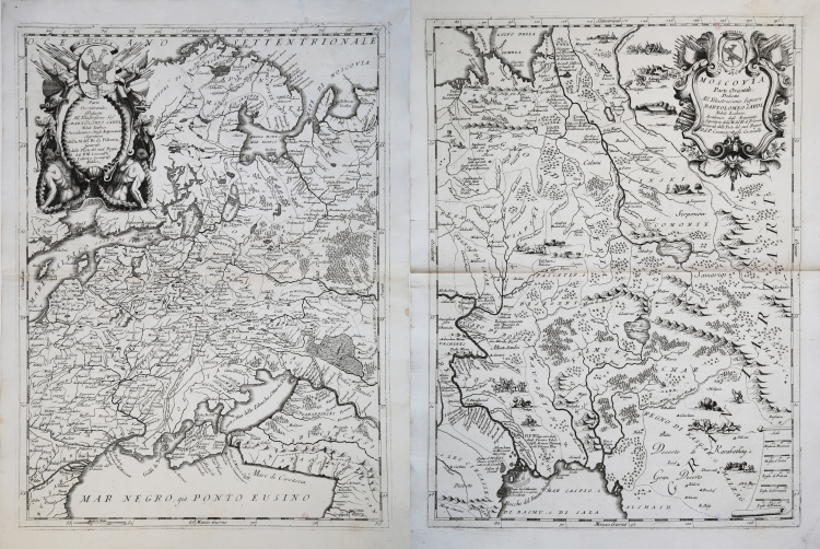
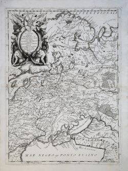
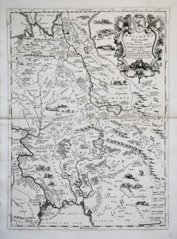
Nice example of Coronelli's two sheet map of Russia, extending from the Baltic and the Black Sea in the west to Gran Tartaria in the East.
Coronelli's map of Russia is one of the most detailed and elaborate maps of the 17th Century, providing tremendous detail in the fine exacting style which characterizes Coronelli's maps.
The map is further embellished by two elaborate decorative cartouches and many vignettes of indigenous peoples, villages, hunting, animals, etc, including depictions of the nomadic tribes extending north from the Caspian Sea to east of the Gulf of Nova Zembla and the Cosack warriors in the southeast part of the map.
The map is taken from Corso geografico universale, o sia la terra divisa nelle sue parti e subdistinta ne' suoi gran regni. Esposta in tavole geografiche ricorrette et accresciute di tutte le nuove scoperte, ad uso dell'Accademia Cosmografica degli Argonauti dal Padre Maestro Vincenzo Coronelli M. C. Cosmografo della Serenissima Republica di Venetia. Dedicata alla Santità di Nostro Signore Innocenzo XII. P. I. In Venetia, a spese dell'autore. MDCXCII.
Coronelli lived a period of extraordinary editorial fecundity starting from 1689, when he had the chair of geography at the University at the Procuratie, with the publication, in 1690, of the first volume of the Atlante Veneto. Under the name of Atlante Veneto goes the entire collection of thirteen works composed over the next decade, from the Isolario to the Specchio del mare. In reality, only some of these works can be defined as atlas, and are of very unequal value, since we go from original and fundamental works such as those mentioned or the Corso Geografico to works of compilation or simple collections of views. The Corso Geografico came out in several editions with different numbers of maps - sixty-eight maps in 1689-92; one hundred and seventy-three maps in 1692; two hundred and sixty maps in 1694-97 - which were also sold separately, at the rate of six a month for two years. The maps were alle engraved between 1688 and 1692 in the well-equipped cartographic workshop of the Frari convent, where foreign engravers also worked.
Copperplates, printed in two sheets, still unjoined, very good condition.
Vincenzo CORONELLI (Venezia 1650 - 1718)
|
Cosmographer, geographer, biographer, encyclopedist, globe maker, inventor, expert of engeneering and hydraulics. Extraordinarily versatile mind and an extremely tireless man, he produced more than 140 pieces in different genres. At the age of 15, he entered the Franciscan Order, which he then guided as Gran Generale from 1699. He became famous as geographer and mathematician, awakening the interest in these subjects in Italy at the end of the XVII century. He travelled a lot, seeking for all that was new, and keeping a correspondance with the most important intellectuals of his time. In 1681 Louis XIV wanted him to go to France, to entrust him with the task of making two terraqueous globes (Marly Globes), with a diameter of 4 metres. Once he came back to Italy, in 1685, he became Cosmographer of the Venetian Republic, where he taught geography and founded the first geographic accademy, called The Argonauts Accademy. In his whole life he produced more that 500 maps; some of them can be found in his most famous works, such as the Venetian Atlas (1690), the Island Book of the Venetian Atlas (1696-97), the Book of Globes (1693). As far as his scientific method, he didn’t elaborate new cartographic systems, but followed the theories that were considered most popular and effective at his time, based on the Copernican system. The main characteristic of his charts is the high quantity of toponymic and historical information. In his most famous and dense work, the Venetian Atlas, we can find about 1100 plates, 200 of which are extremely technical and this is the reason why it is considered the first Italian atlas to describe and illustrate the whole world with charts and maps. It was published in 13 volumes, starting from 1690, and it took nearly ten years to finish it. It is divided in different parts, the most important are the Atlas itself, then the Island Book, the Corso Geografico and the Teatro delle città.
|